We’re nearing the end of an incredible rain event over the northwest and northern Houston metro area. A final line of major storms moved through the northern half of the metro area this morning, a little before sunrise, and now it seems like the organized activity is finally ramping down. Here’s a look at rainfall totals between 5am CT Thursday, and 5am CT Friday:
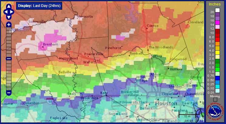
Some areas of Brenham recorded nearly 20 inches of rain in a 24-hour period, shattering previous records for rainfall. Additionally some areas of southwest Montgomery County also received in excess of 14 inches of rain. Needless to say travel through these hard hit areas is not advised this morning. If you’re concerned about flooding, and you should be for some locations along the Brazos River, Spring Creek and the San Jacinto River, this is a good link to check. Just click on the sensor near your home to get a flood forecast.
The city of Houston remained relatively unscathed, with areas along and near Interstate 10 getting about an inch of rain or less, and areas south of I-10 getting almost no rain at all.
So what comes next? Right now the entire metro area is going to see a reprieve from storms, including the hardest hit region north and northwest of the city. Some of the forecast models are trying to bring back another round of storms this afternoon and evening, but the atmosphere is pretty worked over. Additionally some drier air is starting to move into the region from the southwest. So while I am not ruling out the additional development of heavy thunderstorms later today, my guess is that we’ll only see some scattered activity later this morning or afternoon as we get daytime heating and the seabreeze cranked up.
For Memorial Day weekend I think we’re going to see similar conditions, that is, highs in the mid- to upper-80s, with a chance of scattered showers and thunderstorms primarily during the afternoon and evening hours. I am cautiously optimistic that we will not see organized storm activity.
Posted at 6:55am CT Friday by Eric Berger
Around here, I guess it is simply a matter of when it is your “turn”.
For us, it was May 13 last year. The only time in the 40 year history of our subdivision that houses ever flooded.
Eric, in my 35 or so years here, it seems that apart from tropical rains, it is the areas north of I-10 flood more often and worse than those of us to the south. Any truth to that?
Not really, especially when it comes to tropical weather. TS Claudette (Alvin) comes to mind.
Thank goodness it’s over for the most part.
The last two major rain events seem to have hit a wall at I-10. Not sure of the why, but it is pretty interesting to see