Good morning. Strong storms approached the western Houston metro area on Tuesday evening, but fortunately they died as they moved into western Harris County. Unfortunately we probably won’t be as lucky for the rest of the week.
TODAY
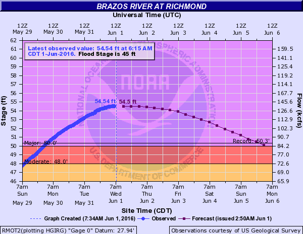
Tuesday night’s rains over the Brazos Valley certainly didn’t help with the rise of the Brazos River, which is now expected to crest near 55 feet near Richmond tonight, about 10 feet above flood stage.
Along with daytime heating we may see additional development of heavy rain later today, but the upper-level low pressure system that’s really going to drive the potential for flooding later this week is still off to the west. So we might also see a mostly dry day.
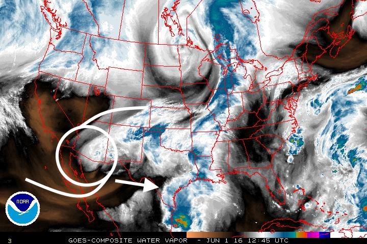
After today we are going to have a similar set up that has driven large rainmakers during April and May: large low-pressure systems in the atmosphere moving in from the west, pulling in moist air off the Gulf of Mexico, and being recharged continually by this flow of warm, moist air. In the image below we see this upper-level low over the southwestern United States and Mexico. However in this configuration it is lacking the moisture (reddish hues indicate drier air). This will change as the system moves into Texas over the next couple of days.
THURSDAY-SATURDAY
All of this means we’re going to see the potential for very heavy rain beginning tonight through Saturday. It is not possible to say when, or where, the heaviest rains are likely to come. What we can say is that most parts of the Houston region are likely to receive between 2 and 6 inches of rain, with localized areas possibly receiving 10 inches or more. Flooding will depend upon two factors: where the rains come, and how quickly. Obviously the western half of the area is much worse off, flooding-wise, than the southeastern quadrant of the city. So heavy rains west of Houston, and along the Brazos River basin, would be catastrophic.
In terms of amounts, 3 inches of rain spread out over three days is manageable for most of the area. But if 3 inches come in 45 minutes, that will prove too much for almost any part of the region to handle.
I would like to be more precise about rainfall totals, but that is just not possible. Simply put, be prepared for the possibility of very heavy rain during the next four days.
SUNDAY and BEYOND
By Sunday a chance of heavy rain will remain, but we might be able to begin looking toward a drier period—finally. I think we’ll move into a more summer-like pattern of highs around 90 degrees by Monday or Tuesday, with scattered afternoon showers driven by the sea breeze. But let’s get through this weekend before worrying about next week’s forecast.
Posted at 8:30am CT on Wednesday by Eric Berger
Thanks Eric,,,,and good luck to all those Ft Bend residents suffering…..
I’m driving to Austin Friday morning for my niece’s graduation. Any idea how the weather might be between Katy and Austin???
Potentially heavy rains. We probably won’t know conditions for Friday, with any precision, until Thursday afternoon or so.
Yikes… I’ll watch Thursday for your updates. Thanks!
So, did we break the 90 degree record??
No. I’ll have an update on that later today.
We made it to June without hitting 90* yet. Isn’t that worth at least a hot diggity dog?
Yes. Will post more about this this afternoon.
Going on a cruise on Saturday leaving from Galveston. Any chance the weather will affect the ship’s departure?
I honestly don’t know the rules regarding cruise ships and weather, but any effects would probably be greater in terms of getting to Galveston rather than leaving the island.
If west Houston ends up getting the heavy rain, will this in any way compromise the integrity of the Addicks dam? Or is this scenario not as much of a worry anymore?
Always possible, but it would probably require more rain than this system is likely to bring.
Just had a heavy shower here in Atascocita, with a lot of red and yellow on the radar south of us.
Was planning on a day trip for work to San Antonio and back tomorrow — think I should cancel? Or go and wear floaties?
Tentatively go for it. I mean we are not going to see a solid mass of rain for three days, so Thursday might be all right. But I’d definitely check conditions tomorrow morning before leaving.
Flying to Salt Lake City tomorrow morning at 8 am. Should I expect delays? A bumpy ride? Both? Nervous flyer here!
Just depends on what develops, Tina. Tomorrow morning may be OK.
Thanks, Eric! I’m a long time follower, congrats on the site!
How do you think Spring Creek and Cypress Creek look like going into this rainy week? Also, do you think another MCS is still possible with this? Thank you for all that you do!
It’s going to depend on where the rain falls, in terms of creek levels. And yes, I would expect at least one MCS to develop during the next few days.