Houston faces a significant rain threat later today and during the overnight hours, and the recent forecast model trends are concerning. I think there are two main threats we must consider: the potential for severe weather, and, separately, very heavy rains.
SEVERE STORMS
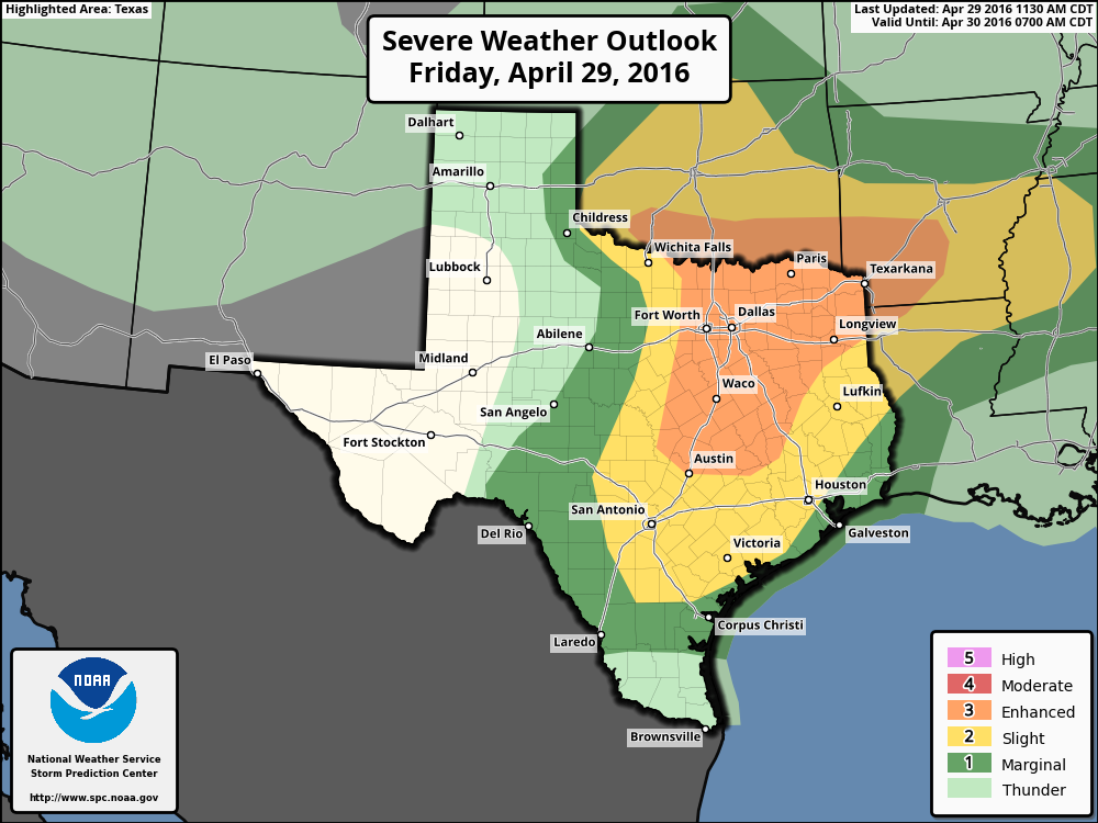
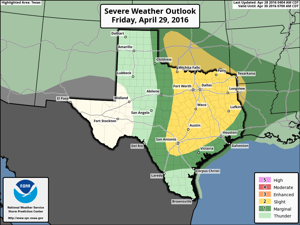
Much of the Houston region falls into the “slight” risk of severe weather for tonight from NOAA’s Storm Prediction Center. I believe this may undersell the risk a little bit.
Severe weather outlook for Friday and Friday night. (NOAA)
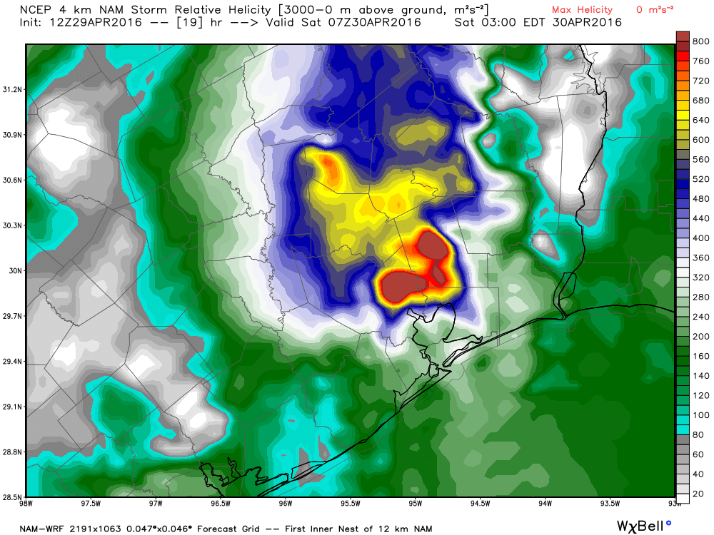
One of the variables forecasters look at when trying to gauge the possibility of severe weather is helicity, which is essentially a measurement of rotation in the upward drafts of a storm system. The greater this value, the higher the threat of tornadoes and damaging winds.
For example, the latest run of the NAM model shows some very high helicity values over much of the northern and northeastern part of the Houston metro area for late tonight. Note that values above 400 allow for the possibility of tornado formation.
NAM model helicity forecast for 2am CT Saturday morning. (Weather Bell)
It looks like it’s going to be another one of “those” weekends here in Southeast Texas. We’ll have rain, storms, and potentially flooding to contend with, and all the while, we have a good deal of uncertainty still in the forecast. Here’s a short breakdown. I’ll follow it with an FAQ type section at bottom.
First, just a reminder: A Flash Flood Watch is posted for Houston and primarily the counties north and west of the city starting later today and going into Sunday morning.
TODAY
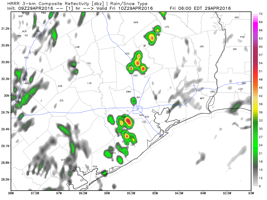
I don’t foresee a lot of issues this morning…if any at all. By mid-afternoon, storms should have started in Central Texas, along I-35 and points east. These will organize and spread east toward our area by late afternoon or evening. Storms this afternoon and evening will have the potential to be strong to severe. The main threats will be hail and damaging wind, and given how saturated the ground is, any sort of strong winds can be more problematic than usual. The tornado threat is low, though it isn’t zero (and as we sadly saw in Tomball the other morning, it doesn’t need to be a high risk or a strong tornado to be tragic, so please heed any warnings if issued). Obviously, our main focus will be flooding.
Simulated forecast radar for today. Storms fire along I-35 this afternoon & move toward Houston this evening. (Weather Bell)
TONIGHT
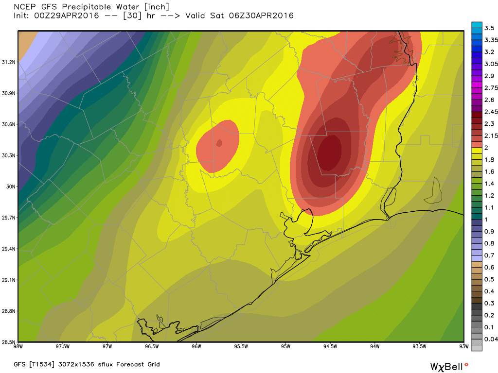
This is where confidence drops and our risks for flooding begin to go up. I expect we will see repeated rounds of showers and thunderstorms around the region. It’s still a bit difficult to say exactly who will see the most persistent storms, but anywhere in the area around Houston (north, west, or even south of the city) stands the potential to see this happen. It’s simply too tough to say where with any specificity. We will update you on this again later today. But the Friday night timeframe is the one we’re most concerned with, namely because we’ll have a substantial amount of atmospheric moisture to work with.
GFS Precipitable Water (PWAT) forecast this evening shows summer-like levels of available moisture. (Weather Bell)
Usually once you get over 2″, you’re talking considerable moisture, which means that any thunderstorms can produce torrential rain. The concern is that a boundary of storms could sit over one area and tap into this moisture. Hopefully this isn’t what occurs, but it’s something we have to watch.
The National Weather Service said this afternoon that a Flash Flood Watch will go into effect for much of Metro Houston (basically along and north/west of US-59/I-69) beginning Friday afternoon and continuing through Sunday morning. This includes the areas hardest hit by last week’s flooding.
Counties under the Flash Flood Watch Friday-Sunday (Iowa State/NWS)
As Eric pointed out this morning, there’s good reason for this. Most bayous in the city (Buffalo Bayou an exception) are back at their baseline levels. But, outside the city, streams, creeks, and bayous are running a few feet higher than normal still. And with a soggy ground any additional rain is unwelcome and can cause flooding concerns depending on how quickly it falls.
Basically, at this point all you need to do is continue to watch the forecast. There’s a bit less certainty with this event than there was last week. Also, it can’t be underscored enough that the rain totals implied by all models with this event aren’t anything like the last one. We want you to be prepared but not to panic here. We still don’t know exactly where the heaviest rain will fall, but we know there will be a few spots that see a pretty substantial amount of rain (not 15-20″ like last week, but 4-8″ in a few spots isn’t impossible).
So just stay tuned in through the weekend, especially if you have to travel around the area or live in an especially flood prone spot. We will have you covered.
Good morning. After another day or so of quiet weather we’re going to have to face another period of potentially heavy rain on Friday night and Saturday.
TODAY
Houston will see warm temperatures on Thursday, but how warm depends up the extent of cloud cover. If we’re mostly sunny temperatures could rise into the upper 80s, to near 90 degrees. If there are some clouds, or a scattered shower near where you live, temperatures will probably remain in the mid-80s. In either case, it will be a warm, almost-summer-like day.
FRIDAY
After a slight chance of showers and thunderstorms developing to the north of Houston on Thursday night and Friday morning, we’ll see better rain chances later in the day. It is possible we’ll see some thunderstorms move in from the west later on Friday, during the evening hours. For now the west-northwest part of the metro area lies under a “slight” chance of severe weather (damaging winds, hail and possibly a tornado) on Friday and Friday night.