After severe thunderstorms in Houston, a reprieve until this weekend

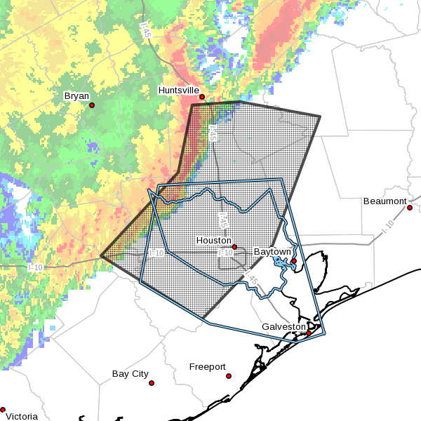
As noted earlier, a nasty line of severe thunderstorms moved through Houston this morning, bringing especially unpleasant conditions north of Interstate 10, with downed trees and power lines (causing one death). Winds gusted up to about 60 mph across much of the region. At least two tornado warnings were issued although neither has been confirmed as of yet. By 6:20am CT about 125,000 CenterPoint customers were without power, mainly in northern Harris and southern Montgomery counties. The only comfort is that because the storms moved quickly, they only had time to drop 0.5 to 1 inch of rain across the region.

TODAY

With the main line of storms moving into the Gulf of Mexico and east of the Houston metro area by about 7am, for today the main event has ended. Some scattered shower and thunderstorm activity will be possible in the wake of this system later this morning and afternoon, but it will not be nearly so organized or severe. In short, despite the inclement weather earlier, it should be safe to resume normal activities this morning across the Houston metro area. Highs today will be in the mid-80s.

THURSDAY

We should see a bit of a break from storms, but not from heat. Look for highs in the upper 80s. With enough Sun we might come close to hitting 90 degrees for the first time in 2016, although I hope (and don’t think) that will happen. Hello, summer?

See full post

Houston under a severe thunderstorm warning as a line of storms approaches

As the southern edge of a major storm system moves approaches Houston the western half of the metro area is under severe thunderstorm warning this morning until 5:30am CT.

Area of severe thunderstorm warning in effect through 5:30am CT. (National Weather Service)


In addition to heavy rain (about 0.5 to 1 inch with this line of storms) this means there may be strong winds, hail and possibly even a tornado over a northern part of the city near Spring. I expect the thunderstorm warning area to expand eastward as we get closer to sunrise.

One saving grace from this system is that it continues to steadily move eastward and should move out of the eastern half of the Houston region by 7 or 8 am CT. After the main line of storms moves through we could see some additional scattered showers and thunderstorms later this morning and afternoon. But as for the potential for very heavy rain and severe weather, this is the main event.

Posted at 4:45am CT Wednesday

Update on potential for storms in Houston Tuesday night and Wednesday

We’re starting to see storms fire up in west Texas and Oklahoma which will progressively move eastward across northern Texas later this evening. These storms will likely bring heavy rains, hail and tornadoes to the warning area below, including Dallas-Fort Worth complex. Conditions could get pretty nasty.

Severe weather outlook for storms tonight. (NOAA)

See full post

Houston’s Tax Day flooding put into historical perspective

Note: This is the first in a series of reports by Matt Lanza that puts the Tax Day floods into perspective, and discusses what Houston should learn from this natural disaster.

On Monday afternoon the Harris County Flood Control District released its first official summary of the historic flooding that occurred last week in the greater region. I’ve read through it and compiled some highlights for here. (You can also view the report yourself in its entirety here). A serious thank you to Jeff Lindner at the flood control district who has worked tirelessly since last week to provide critical, useful, and interesting information to put this event into context and keep the region informed. He is also a must-follow on Twitter if you’re into weather, haven’t done so yet.

Report highlights

  • Rainfall rates of 1″ in just 5 minutes were observed in Harris County. The maximum hourly rate was 4.7″. The maximum amount in 12 hours was 16.7″
  • Harris County averaged 7.75″ of rainfall for the event. That’s equivalent to 240 billion gallons of water falling on the area. This exceeded Memorial Day (162 billion gallons) by almost 80 billion gallons of water. That event was more confined, whereas the Tax Day rains were much larger spatially.
Map of 12 hour rainfall totals and location/flooding description of significant waterways. (HCFCD)
Map of 12 hour rainfall totals. Click to enlarge. (HCFCD)

See full post