A warm weekend—but cooler weather and widespread showers loom for Houston

I’m back—and I bring some good news. First of all I want to thank Matt for holding down the fort while I grabbed some vacation. It was nice to unplug for awhile. But now I’ve returned, and I’ve come with much more promising rain chances and relief from the heat.

Yes, some areas of Houston received a very good dousing last week, particularly central Houston. But most of the area has seen 1.0 inch of rain or less during the month of July, at a time when temperatures have consistently been in the mid- to upper-90s. (This leads to a very high pan evaporation rate, meaning soils dry out very quickly). So some rain is welcome, both for our trees and green spaces, but also to moderate daytime temperatures. And some is coming.

This weekend

The sprawling high pressure system that’s been anchored over the south-central United States, including much of Texas, is moving off to the west. But there’s likely going to be a modest capping inversion today and Sunday, and moisture levels aren’t the highest, so I think we’re only going to see some scattered rain showers this weekend, primarily during the afternoon hours. Rain chances are best to the east of Interstate 45. Lacking widespread rain, most areas will likely see highs in the mid-90s.

Monday and Tuesday

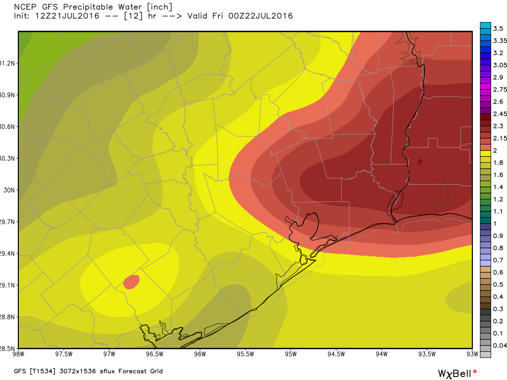
By Monday we’re likely to see atmospheric moisture levels climb above 2.3 inches of precipitable water—which is very good for rain chances.

Precipitable water levels  are likely to surge on Monday and Monday evening in Houston. (Weather Bell)
Precipitable water levels are likely to surge on Monday and Monday evening in Houston. (Weather Bell)


This, along with some low pressure moving into the area from the Gulf of Mexico should be enough to bring some fairly widespread rain showers into the metro area. I think much of Houston can probably hope for 0.5 to 1.0 inch of rain, and there’s the potential for heavier, more localized rain showers. Clouds and intermittent rain should hold high temperatures for both of these days to the low 90s, if not 90 degrees.

Wednesday and beyond

Pressures appear to rise beginning Wednesday, but it doesn’t look as though we’re going to see dominant high pressure. This should hopefully keep daytime temperatures in the low 90s, with at least some scattered rain showers most days.

Posted by Eric on Saturday at 6:55am CT

Hot Houston weekend

Yesterday was a bonafide scorcher for Houston, with another 98° day. Really, it was a scorcher almost everywhere in the Eastern and Central U.S. We’re squished under a heat dome here in Texas. Fortunately for us, the heat dome will begin to break down, or at least move around enough this weekend to open the Gulf back up a bit for some showers. It’s going to be hot, but hopefully some of us see a little relief at least.

WEEKEND

Rain chances will still be on the lower side today, with most activity likely south or east of Houston (most, but not exactly all). The majority of the area should stay dry and hot and humid, but rain chances aren’t quite zero. As we go into Saturday and Sunday, a surge of precipitable water, not too uncommon for this time of year, will come our way from the south and east.

The forecast for precipitable water lurches upward this weekend, increasing our chances for daytime storms. (Weather Bell)

This sets the stage for more “juice” available to fuel daytime storms. So I think coverage of thunderstorms on both weekend days will be more than we see today. Think about what happened on Sunday, Monday, and Tuesday of this past week, and I think that’s a reasonable analog case to what we see this weekend: A scattering of storms that dumps on a few folks, but leaves others high and dry.

See full post

Texas sizzles onward

We had a few showers again on Wednesday, but nothing too exciting by Southeast Texas standards. We may do it once again today, but heat will be the main story.

In case you missed it, Braniff Davis was back with another “Weather Whys” post last evening, discussing the sea breeze and the Gulf of Mexico and how they influence our weather. Check it out here.

TODAY AND FRIDAY

No big changes in the weather for the next couple days. I still expect it to be hot and humid both days, and I still anticipate we will see at least a couple showers blossom on radar each day. Exactly where they go and how widespread they’ll be is up for debate. A weak disturbance rotating around the Plains heat dome will probably set off more organized, but scattered storms in western Louisiana today. I doubt these make it to Houston, but if you live east of the city (particularly, if you live closer to Beaumont/Port Arthur), you may get a downpour later this afternoon. We may try and repeat this on Friday with another disturbance, perhaps getting a bit closer to Houston. High temperatures should again aim for the mid to upper 90s both days (hottest inland, cooler at the coast).

Forecast precipitation today shows the best concentration of storms in Louisiana, although some should cross into East Texas also. (Weather Bell)

See full post

Summer (sea) breeze: Does it make Houston feel fine?

If you’ve lived in Houston–or any other place near a large body of water, for that matter–you’ve heard the term “sea breeze” quite a lot, especially during the summer. We often discuss the sea breeze in relation to those scattered, sometimes intense, thunderstorms we saw pop up over the region since Sunday. But what is a sea breeze, and how does it work?

See full post