A brief reprieve from the warmth, and possibly a wet New Year’s Eve

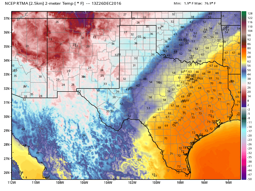
Well that … was a warm Christmas. Although we didn’t quite reach the record set in 2015 (83 degrees), the official high temperature on Sunday was 80 degrees. That gives Houston back-to-back Christmas holidays of 80 degrees or higher. And we’re not going to cool down for a few days still, alas.

Monday

Lows this morning are starting off at around 70 degrees for most of Houston, which is more typical for September than December. And today is going to end up feeling a lot like Christmas Day, with partly to mostly cloudy skies, southerly winds (although not as gusty) and highs near 80 degrees. There will be the possibility of scattered showers again, but accumulations should be slight. Lows tonight will again fall to only around 70 degrees.

Half of Texas is quite warm today, but the other half is cold behind a front that’s not going to make it all the way to Houston. (Weather Bell)

See full post

Christmas weekend in Houston: Eggnog and fog

Though it won’t feel like it, Christmas weekend is upon us. Some of us may have trouble seeing it though; not due to too much eggnog but probably due to some dense fog. Let’s dive into the details.

Today

A warm front is lifting through today, allowing warmer and more humid air to begin to flood northward. As this happens, we are seeing some fog around this morning. We already have low clouds, drizzle, showers, or steady light rain around also, and that may continue throughout the day.

Today shouldn’t be a washout, but occasional light rain, drizzle, or showers is likely. (Weather Bell)

Even with clouds and showers, we will warm up to the low 70s this afternoon.

See full post

Have yourself a humid little Christmas, Houston

Just a quick update today as the forecast has not changed much for the greater Houston area—and also, life sometimes finds a way of intruding on one’s work!

Today

A weak front moved into the region this morning, and it’s going to make for a gray, fairly cool day with highs likely only reaching the upper 60s. Skies may become partly sunny later this afternoon, and lows tonight should fall into the 50s for most of the region, except for along the coast. Enjoy the “winter” weather while it lasts.

Friday and Saturday

The onshore flow resumes by Friday morning, washing out the short-lived front and setting Houston up for a warm holiday weekend. The returning moisture will bring at least scattered showers and perhaps a few thunderstorms into the forecast for Friday and Saturday, and I expect high temperatures in the low- to mid-70s both days with partly cloudy to cloudy skies.

Christmas forecast highs range from the 40s in the Panhandle to the 80s in the Valley. (Weather Bell)

See full post

Winter “begins” today but Houston will leap ahead to spring

The winter solstice began early this morning, as the Sun reached its lowest point in the sky. Paradoxically, instead of seeing cooler weather over the next week or 10 days, Houston will instead warm back up over the Christmas Holiday, and perhaps most of the following week.

For the northern hemisphere today is the “shortest” day of the year, in terms of daylight. With a sunrise at 7:12am CT and sunset at 5:26pm, there is just 10 hours and 14 minutes of daylight. (At mid-summer the day is 14 hours, 3 minutes long). Here’s how that compares with the rest of the northern hemisphere on the winter solstice.

(Brian Brettschneider)

See full post