A quick update on a rainy Monday for Houston

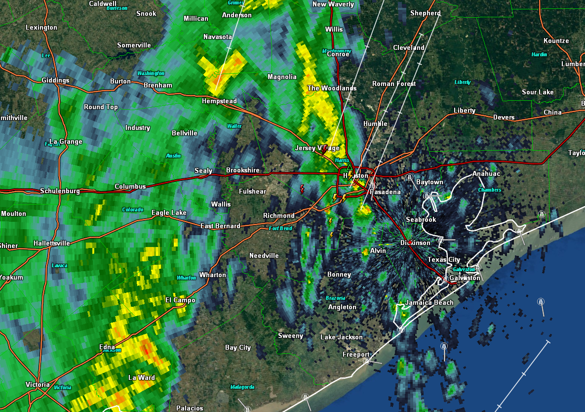
As we’ve been indicating in previous forecasts, Monday is shaping up to be a rainy day in Houston—although we’re not expecting anything too extreme for the region.

It appears as though heavy showers will develop well to the west of the region on Monday morning, before sunrise. They should move into the Houston region between 6am and 9am CT, so there is definitely the potential for a wet mess on freeways and feeders for the Monday morning commute.

NOAA rain accumulation forecast for Monday and Monday night. (Weather Bell)


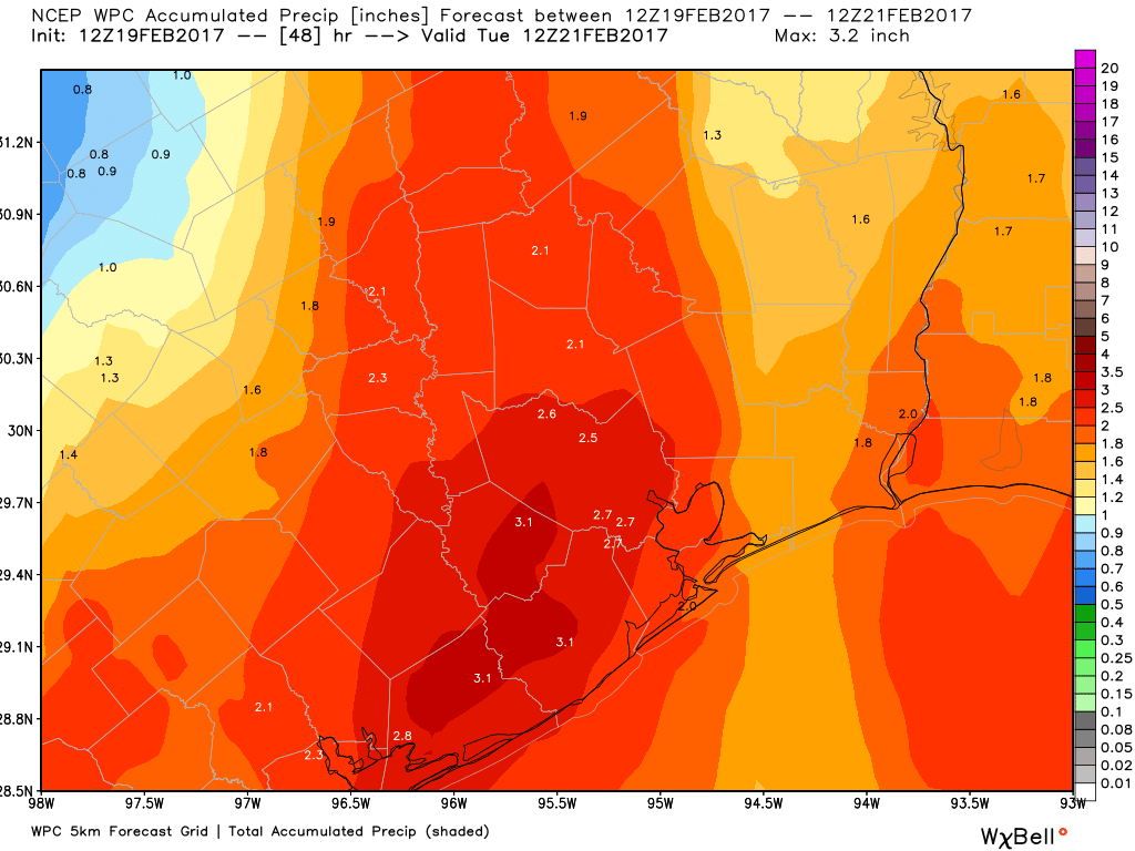
I anticipate most areas will see about 1.5 to 2.5 inches of rain on Monday, before showers and thunderstorms taper off during the evening or overnight hours. For Houston, the primary concern is smaller regions where heavy storms establish themselves, and slow down. A few parts of Houston could see 5 or more inches of rain on Monday, which could cause some street flooding. That’s what we’ll be watching for tomorrow morning, and as the day progresses. We will, of course, return with a full update early Monday.

Posted at 8:30am CT on Sunday by Eric

(Space City Weather is sponsored this month by Darrell Lee’s The Gravitational Leap)

Gray Friday, great Saturday, rain beyond

After a day or two to remind us that Houston can have beautiful weather in the cool season, we’ll go gray today, with a little rain. We begin the march back to a warmer pattern as well.

Today

Radar shows sporadic rain across the area this morning. Some of what you’re seeing on radar may not actually be reaching the ground well north of Houston. The air is still a bit dry there yet.

Occasional showers and rumbles of loud thunder as of 6:35 AM are working their way east through the area. Nothing serious however. (GR Level 3)


We’ve also heard some thunder in and around Houston this morning. That should kick off to the east over the next couple hours. The rest of the day likely sees scattered rain, mainly in southern parts of the area. Some of it could be moderate to briefly heavy along the coast. And yes, rumbles of thunder will continue to be possible, but we aren’t expecting any severe weather from this system. It’s entirely possible some inland areas see nothing more than a few raindrops. Most of us will see gray, cloudy conditions for much of today.

Models show rainfall & some thunder working through the region today. The steadiest will be at the coast, and all rain should be through our area by mid to late afternoon. (Weather Bell)


Temperatures will grind upwards into the upper 60s to near 70 degrees this afternoon.

(Space City Weather is sponsored this month by Darrell Lee’s The Gravitational Leap)

See full post

Space City Rewind: Houston’s Great Snow of 1895

Note: In our second installment of the Space City Rewind, we tackle the biggest snow on record in Southeast Texas. Our first installment about the November 1992 tornado outbreak can be found here.

“All of Wednesday night polar spirits swept the earth until boundless snow had deformed the withered heath and the people of this section for the first time within the memory of the oldest inhabitant, looked out upon nature fringed with a beard made white with other snows than those of age.” – Brenham Daily Banner, February 15, 1895

Back on Christmas Eve in 2004, much of South Texas was blanketed in white, as a perfect setup to create a miraculous White Christmas occurred. Galveston received four inches of snow, Angleton six inches, Friendswood three inches, and Bay City 8-10 inches. While the 2004 Christmas Eve miracle stands almost on its own for modern Southeast Texas snowstorms, the great Valentine’s Day snow of 1895 stands alone as Southeast Texas’s and the Gulf Coast’s greatest snowstorm of all-time. The following interactive map shows snow totals from this remarkable event, which affected a swath from Texas to Maryland.


Above: An interactive map with snow reports and some details from the 1895 storm

So why did this event occur? How disruptive was it for coastal residents? Will we ever see its like again? Put your feet up, because the latest installment of the Space City Rewind takes you back to the 19th Century: The Great Snowstorm of Valentine’s Day 1895.

See full post

After cold spell Houston to warm up, face potential for heavy rain

Good morning. Houston is enjoying its coolest morning since late January, with lows in the low- to mid-40s across the region, but warmer air is on the way. And then, on Monday, heavy rain is possible.

Today

This morning’s northerly winds will swing back around to come out of the south later today, but the region should still see partly to mostly sunny skies, with highs of around 70 degrees. Lows tonight will be about 10 degrees warmer than those on Thursday morning.

Friday

A bit of a complicated forecast as overnight winds start to bring some Gulf moisture back into the area. In addition, conditions in the upper level of the atmosphere will favor rising air, which could generate some rain showers and possibly thunderstorms during the morning and early afternoon hours—especially along the coast.

Precipitable water values for Friday, at Noon, show where rain is most likely. (Higher values indicate more moisture for the atmosphere to work with). (Weather Bell)

The forecast for rain is fairly tricky, because while some areas may see some nasty little storms, most parts of the region probably won’t. With partly to mostly cloudy skies high temperatures should remain at around 70 degrees.

(Space City Weather is sponsored this month by Darrell Lee’s The Gravitational Leap)

See full post