Houston to see 80-degree days for awhile

Spring has come to Houston, and that means a steady diet of 80-degree temperatures for at least the next week or so. A risk of storms remains on Friday.

Today and Thursday

We’ll see continued warm weather—for this time of year—as high pressure sort of sways across Texas during the next couple of days. Expect partly to mostly cloudy skies and highs in the low- to mid-80s. These are near-record high temperatures for this time of year. Lows will moderate into the low- to mid-60s. The primary concern will be the possibility of some scattered, dense fog.

Friday

As we’ve been discussing, an upper-level low pressure system, and an associated cold front, will move off the Rocky Mountains later this week and drag what will probably be a significant line of storms across parts of the central and southern United States. Most of the action should be north of the Houston metro area, but we’ll need to be wary of the possibility of a few severe thunderstorms north of interstate 10.
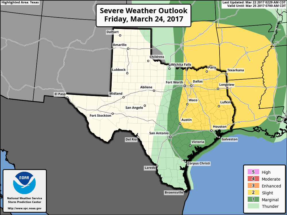
Severe storm outlook for Friday afternoon and evening. (NOAA)

(Space City Weather is sponsored by an anonymous donor this month)
See full post

Warm Gulf to keep Texas warm this week

Good morning. Houston will remain warm this week, with high temperatures near record levels—as was the case for much of the winter. A chance of storms moves into the forecast by Friday.

Tuesday through Thursday

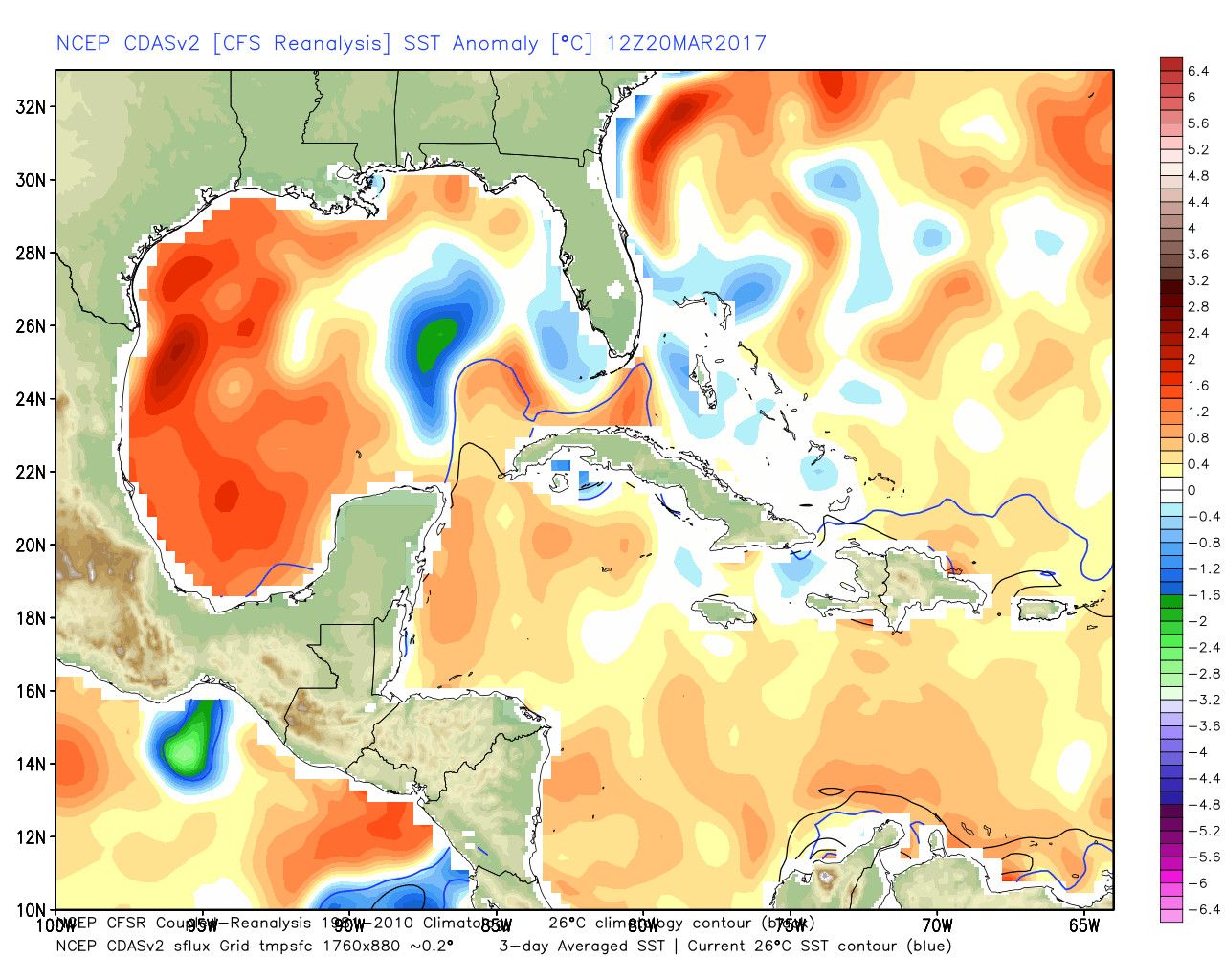
Expect mostly sunny days, with highs around 80 degrees near the coast and mid-80s for inland areas. Why is it so warm? Look no further than the Gulf of Mexico, where for the first time on record, the daily average surface temperature never fell below 73 degrees Fahrenheit this winter. Here’s a map showing the present-day temperature anomaly:

Gulf of Mexico temperatures remain 3 to 5 Fahrenheit degrees above normal along the Texas coast. (Weather Bell)

A steamy Gulf has meant that any time winds blow out of the south, we’re not going to cool down that much over night, and daytime temperatures can warm pretty quickly.

(An anonymous donor has sponsored Space City Weather this month)

See full post

As the Sun rises above the equator, you know what that means Houston

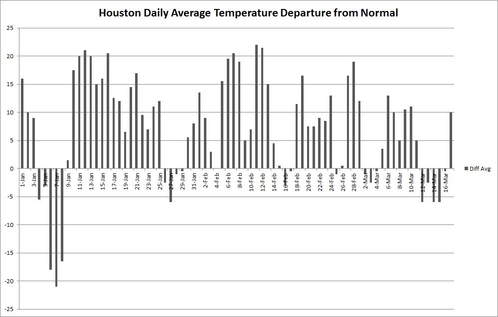
Good morning. Today is the spring equinox, the point at which the Sun crosses the equator. For a nice explanation of why meteorologists generally begin spring on March 1, instead of today, see this post by Braniff Davis. In practical terms, for Houston, this means that days will continue to get longer for three additional months, and we’re going to continue our march toward the dead of summer. It also makes last week’s brief cold outbreak (shown in the graphic below), all the more sweeter.

Daily temperature departure from normal in Houston this year. (Matt Lanza)

Today

It’s warmer this morning than it’s been in Houston for awhile, with lows generally having fallen only into the mid-60s. That’s because in addition to a warm flow moving in from the Gulf of Mexico, some overnight clouds helped keep some of the heat close to the surface. But those clouds should mostly go away later today and allow highs to climb to around 85 degrees (and about five degrees lower along the coast). Lows tonight will be in the mid-60s.

Tuesday and Thursday

Similar weather should continue through most of the work week—lots of sun, highs in the mid-80s, lows in the mid-60s. This is warm for mid-March, but won’t be record-setting for the area expect for perhaps the coast, where Galveston’s record highs for this time of year are around 80 degrees.

(Space City Weather is sponsored by an anonymous donor this month.)

See full post

Worry-free weekend for Houston

Happy St. Patrick’s Day! So the Houston area survived yesterday’s handful of light showers without much trouble. The good news is that we’re on the way to having a weekend without having to worry much at all about any weather.

Today and Weekend

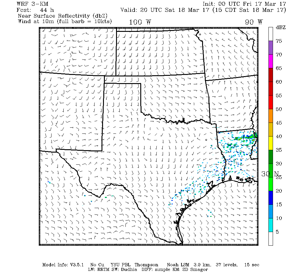
We’ll start with clouds again this morning and partially clear them out through the day. Overall, it should be nice, with temperatures warming into the upper 70s. Yes,a sprinkle or a brief shower could pop up, but it won’t be anything serious. It will be a bit breezy, especially south of Houston. Breaks in the clouds will try to thicken back up tonight. In addition, we could also be talking about a little patchy fog in spots. Saturday will be like Friday with low morning clouds giving way to sunny periods. It’s entirely possible that a brief shower or small storm pops up Saturday, but I’d bet heavily against seeing raindrops in most spots.

Models aren’t exactly bullish on rain chances Saturday, but we have to at least mention it. This particular image is a model interpretation of what could be happening around 3 PM Saturday. (Texas Tech)


Heading into Sunday, we’ll continue onshore flow, but I think any morning low clouds and fog will clear out a little more aggressively during the afternoon. Expect temperatures to hit around 80 or the low 80s on Saturday and low to maybe mid 80s on Sunday.

(Space City Weather is sponsored by an anonymous donor this month.)

See full post