Houston: Get ready for one, potentially final splash of beautiful weather. Never say never, but it’s getting deep into spring now, and any opportunities at comfortable weather can be fleeting around here. But what we have coming this weekend will be absolutely sublime. Let’s get into details.
Today
No real issues are expected today. Yes, an isolated shower could occur, but it looks like a very slim chance. Temperatures will be similar to yesterday, with slowly increasing humidity. Expect mid to perhaps upper 80s this afternoon.
Saturday’s front
Let’s talk cold front. Expect the front to traverse the region from northwest to southeast through the day, arriving in Conroe around mid-morning, Bush Airport and Katy mid to late morning, South Houston around midday, and Galveston through Lake Jackson around early to mid-afternoon.

For those participating in the Ironman North American Championship Texas in The Woodlands Saturday, I wish we could speed the front up six hours, but alas it waits until Saturday morning. It will be a bit challenging, with temperatures starting the event in the mid to upper 60s, warming into the upper 70s by early afternoon. The precipitous drop in humidity expected behind the front probably won’t begin until early Saturday afternoon. Not the worst we’ve seen around here in spring, but probably not ideal either.
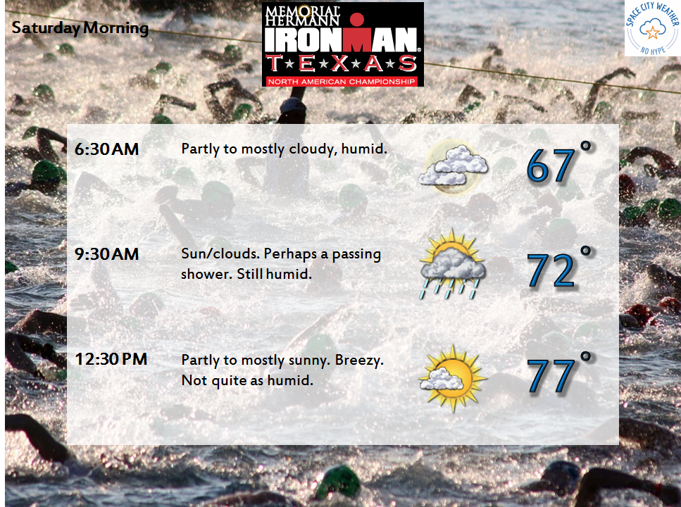
In terms of rainfall, I don’t expect much. A narrow, broken line of showers and maybe a rogue rumble of thunder will be possible as the front moves through. This means some of you may get briefly rained on, others may not. No severe weather is expected. Temperatures will still peak around 80° or so in Houston on Saturday afternoon (cooler north, warmer south). You won’t notice much of a big change until mid to late Saturday afternoon when the refreshing air begins to pour in.
(Space City Weather is sponsored this month by The Mole, a Jonathon Price novel.)
Sunday through Tuesday
Both Sunday and Monday look insanely nice. Sunday will be sunny with a cool northerly breeze. The morning will start with mid 50s in Houston, some 40s north and west. Temperatures may struggle to get to the mid 70s in the afternoon! We repeat the cool, pleasant weather Sunday night into Monday morning, with 40s again possible in outlying areas. Monday should be warmer with highs approaching the upper 70s or even 80°. Humidity will stay low. Onshore flow begins to return Monday night and Tuesday. Tuesday will be warmer with temperatures starting the day in the upper 50s to low 60s. You’ll notice humidity begin to return too, with highs in the low 80s.
Late next week
There’s some uncertainty about the specifics late next week and weekend regarding the weather. We should be back into a typical early summer type pattern by late next week with onshore flow, high humidity, and temperatures likely warming from the upper 60s to at least low to mid 80s in the afternoon (perhaps upper 80s). The big question becomes rainfall. The US weather pattern should transition to a Western trough, Eastern ridge look later next week.
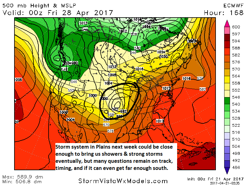
But whether or not that Western US trough and subsequent Plains storm can advance far enough south and east to break the likely cap over Houston and bring us a chance of storms remains to be seen. This could be a setup for some heavy rain and severe weather…or it could stay mostly off to our north and we end up with not much at all. It’s simply too early to say. We’ll keep you posted on rain chances and timing next week though. For those riding the MS 150, stay tuned.
Meanwhile, enjoy the coming blissfully beautiful weather!
I’m very curious and have never understood ‘capping inversion’. I know it keeps the rain away but wondered if you could explain why. Thanks so much!
This post from Eric from last April actually touches on some of this. http://spacecityweather.com/recapping-friday-nights-missed-forecast-saturdays-storms-whats-ahead/
But to put it somewhat simply: Basically a “cap” is where you get a temperature inversion in the atmosphere. Typically it gets cooler as you go higher up, but in an inversion, it actually gets warmer. This basically forces air to stop rising. In order to get clouds and precip, you need rising air. Otherwise, clouds can only get so tall. So a cap is often described almost like a “lid” on storms. For that to break, you need temperatures to cool off aloft and the inversion to break. That can be helped by nearby storms/boundaries, more upward motion from an approaching disturbance, etc. It’s a complex issue worthy of its own post. Perhaps we’ll get Braniff working on one soon!
We won’t know about next weekend until at least early next week, if not midweek, so I really can’t tell you anything new today. Unfortunately, that’s just how we have to handle these things.