A large area of showers and thunderstorms has continued to move into the Houston metropolitan area this morning, and the entire region is under a flash flood warning through 1 pm CT. This post will discuss the immediate effects of these devastating floods and then discuss how we may see an improvement in conditions later today.
FLOODING
Due to 12 to 18 inches of rain falling overnight across western and northwestern parts of the Houston metro area a number of bayous have exceeded their banks. This has led to dozens of high-water rescues and neighborhood flooding. According to the Harris County Flood Control District the following waterways (13 of 22 watersheds) are currently flooding homes in the county:
- Cypress Creek
- Willow Creek
- Little Cypress Creek
- White Oak Bayou
- Greens Bayou
- Brays Bayou (US 59 to 610)
- Willow Water hole
- Keegans Bayou
- Halls Bayou
- Horsepen Creek
- Langham Creek
- Bear Creek
- South Mayde Creek
Water has inundated homes in more than 100 neighborhoods, primarily concentrated on the western side of the county. These rains have affected a much larger area than the Memorial Day Floods, which were concentrated in a relatively small, but heavily populated area of southwestern Houston.
We are at the point where another 3 to 6 inches of rain today across the metro Houston area would exacerbate flooding of these waterways, and put much of the rest of the county into a truly catastrophic flooding situation. But will that occur?
FORECAST
Over the last few hours we have seen the main area of convection sag slowly to the southeast, and away from the areas in northwest Houston hardest hit by overnight storms.
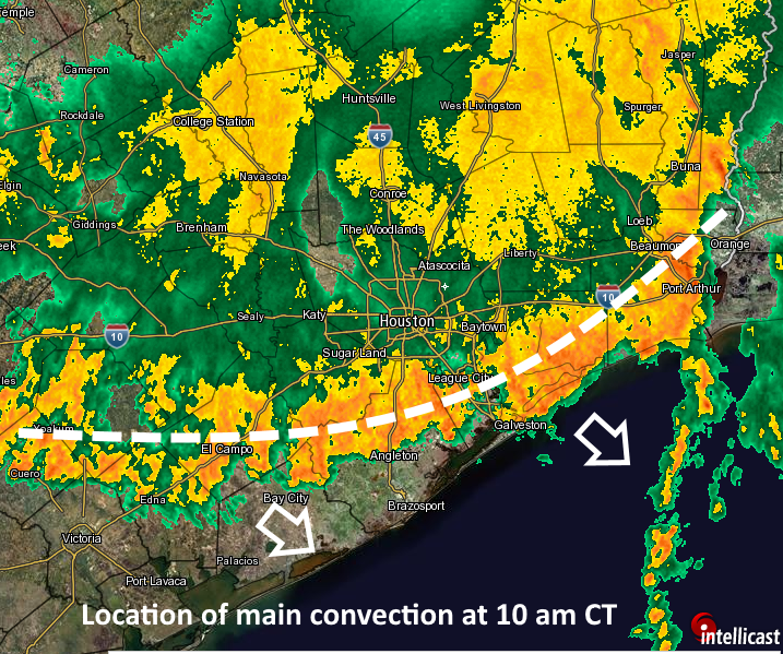
These storms aren’t really weakening right now as they move slowly to the southeast—they have lifting boundaries and ample moisture from the Gulf of Mexico to sustain them at this time.
However this main area of convection, as well as residual cells popping up over more inland areas of the Houston metropolitan area, are likely to see some weakening during the early afternoon hours. Part of the reason for this is that the flow of moisture off the Gulf of Mexico should become less pronounced later today.
So the bottom line is that the storms aren’t going away fast, but over the course of today they should slowly track away from Houston, and my best guess (and as we’ve seen there are few certainties with this event) is that we’ll see a respite from the very heavy rain showers by later this afternoon.
And what does this mean for late tonight and Tuesday? I think we probably will see an additional round of showers, almost certainly weaker than what moved through late Monday and this morning. But how much weaker? I don’t know. Hopefully a lot.
Posted at 10:25am CT Monday
Thanks for your weather feed. It’s the best, in my estimation.
Time stamps would help on these fast changing updates.
Yes, sorry. I sometimes forget!
Eric, I live in League City and work in Galveston, and I just drove to the Island (boy was that fun). Now I see a lot of road closures and alerts closer to home. What is your best guess as to what our drive home will be like this evening?
Better than the drive to work, most likely.
Do you believe that the flooding with subside for school to be in session tomorrow?
Best guess is yes, but I would not commit to that.
Always appreciate your doing this, Eric.
How are the dams holding?
Any prediction for weather tonight and tomorrow morning?
Most likely quiet tonight. See my latest post for more details.
Do you agree with the optimistic forecasts I am seeing?
A discussion of drought conditions in Texas on Friday would be interesting.