It’s been more than two weeks now, but can you remember back to the first part of this month? Very warm nights. Five straight days of 100-degree temperatures. Through the first 13 days of the month, an average high of 99 degrees. Then the big pattern change came, one in which tropical moisture won out over high pressure in August.
This happened:
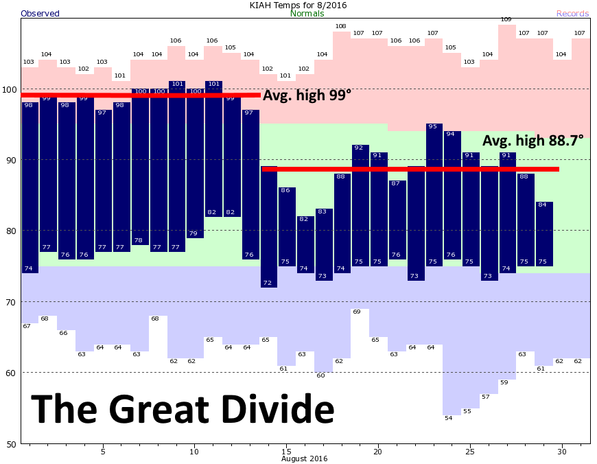
On the graphic above I’ve shown how the average temperature plummeted 10 degrees beginning on August 14th. I know some people have tired of the rain this month, but I’ll almost never tire of it in August. The clouds and precipitation have kept a lid on temperatures, especially after the blistering start to the month. And the good news is this—August is almost over. Fall will arrive some time in the next month.
Today through Thursday
But alas, fall won’t arrive this week. The upper-level low over the northwest Gulf of Mexico that’s been driving intermittent rain showers during the last few days over the Houston metro area is now moving slowly off to the southwest. In its place high pressure will move in, and that will lead to diminishing rain chances today (coastal areas near Matagorda Bay are still likely to see additional rain), and only slight chances on Wednesday and Thursday. This will allow highs to climb from likely the low 90s today, into the mid-90s by Thursday. Who is ready for highs of 96 or 97 degrees? Yeah, me either.
Labor Day Weekend
Sometime on Friday a weak front should move into Houston from the northeast, and this should bring some slightly better rain chances, most likely during Friday afternoon and evening. We’re talking tenths of inches, not inches, of rain, most likely.
This northeasterly flow isn’t going to cool the region down too much, but temperatures should be pleasant enough this weekend, around 90 degrees or a bit higher, with partly sunny skies. While some rain showers will be possible, I’d expect them to be fairly scattered, and over quickly. If your plans involve the beach, I wouldn’t expect the weather to disrupt them. Evenings should also be reasonably pleasant for early September.
Tropics
The tropics continue to be active with Hurricane Gaston, and two tropical depressions, including one in the Gulf of Mexico. While that depression (Nine) will bring several inches of rainfall to Florida this weekend, it’s not going to have any effect of Houston’s weather. All the same, the next four weeks or so remain prime time for Texas hurricanes, so we’ll need to keep a close eye on the tropics for now.
Do you think we will have an early Fall? Cold winter?
Probably not and … who knows. Sorry. I don’t have much faith in seasonal forecasts.
Just the fact we can say, “we’re at the end of August” is a win for me.. It means we’re two (on the optimistic side) to four weeks away from the early arrival of fall!
Count me among the thankful for a few weeks respite from the heat. As someone who begins marathon training in August, the onset of 80F lows is the worst part of the season. Nothing harder than getting back to training with soupy darkness in the mornings. On to the first cold front!
I wholeheartedly agree with you on summertime rain. I’ll joyfully take it over our other summer option: searing heat, drought, and dying plants. Thank you for keeping us informed!
I’m hearing we are transitioning from El Nino to La Nina. What changes to weather patterns might we expect? I recognize that it depends on the strength of these two major patterns.
Thanks!
It’s not clear what we’re transitioning into at this time.
Eric and Matt,
IAH has recorded at least a trace of rain for 17 consecutive days now, with at least 0.1″ on 12 of those days. Is this as rare as it seems, particularly for August?
http://www.wrh.noaa.gov/total_forecast/getprod.php?afos=xxxcf6iah&print=yes
Hobby was on a similar streak, recording measurable rainfall every day since Aug 13 with the exception of Aug 27, which was dry.
I enjoy your blog, but I’ve lived here virtually my entire life. September weather is usually just a continuation of August’s. And Fall? Well, Fall will get here around Thanksgiving.
September is August lite, with the promise of one or two fronts. Either way, it’s better than August.
(chuckling) But NOT fall.
I can’t find any data on whether or not Friday’s storms, if any, will be strong with strong winds and dangerous frequent cloud to ground lightning. Do you have any?