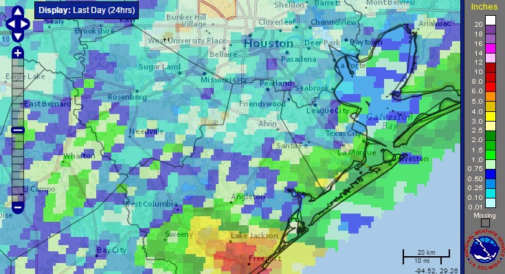
Most of Houston saw cloudy skies, but not too much rain this weekend. But the same cannot be said for some coastal areas, particularly in Matagorda and Brazoria counties. As much as 10 inches fell in the Freeport area, and coastal regions in Matagorda, Brazoria, Galveston and Chambers counties remain under a flash flood watch through at least noon today.
Monday
These coastal areas could pick up another couple of inches today as a slow-moving area of low pressure drifts slowly down the Texas coast. While it is not particularly a threat to develop into a tropical system it will remain a rainmaker all the same.
Truth be told, heavy rain is possible for most of the Houston metro area today, as daytime temperatures warm up. Some parts of town could pick up 1-3 inches whereas other areas see threatening skies, but little to no rain. Highs should remain in the upper 80s.
Tuesday
Conditions should dry out some on Tuesday, with less heavy rain, but we’re still likely to see partly cloudy skies, intermittent rain and highs only of about 90 degrees. Don’t look now, but it’s almost the end of August, and fall isn’t too far around the corner.
Wednesday through Friday
As some high pressure tries to build over the region we should fall back into a nearly summer-like pattern, with highs in the low- to mid-90s and a slight chance of afternoon showers and thunderstorms. Rain chances appear to be a little bit better on Friday afternoon or evening as a weak front approaches the area and may provide some lift in the atmosphere. Expect partly to mostly sunny skies. If you’ve been wanting a break from daily rain, this is it.
Labor Day weekend
Weather for next weekend looks pleasant enough for early September, with partly to mostly sunny skies, highs in the low 90s, and only slight rain chances.
We’re not to the point yet where we can begin to look for real cold fronts, but we’re only a few weeks away from then.
Tropics
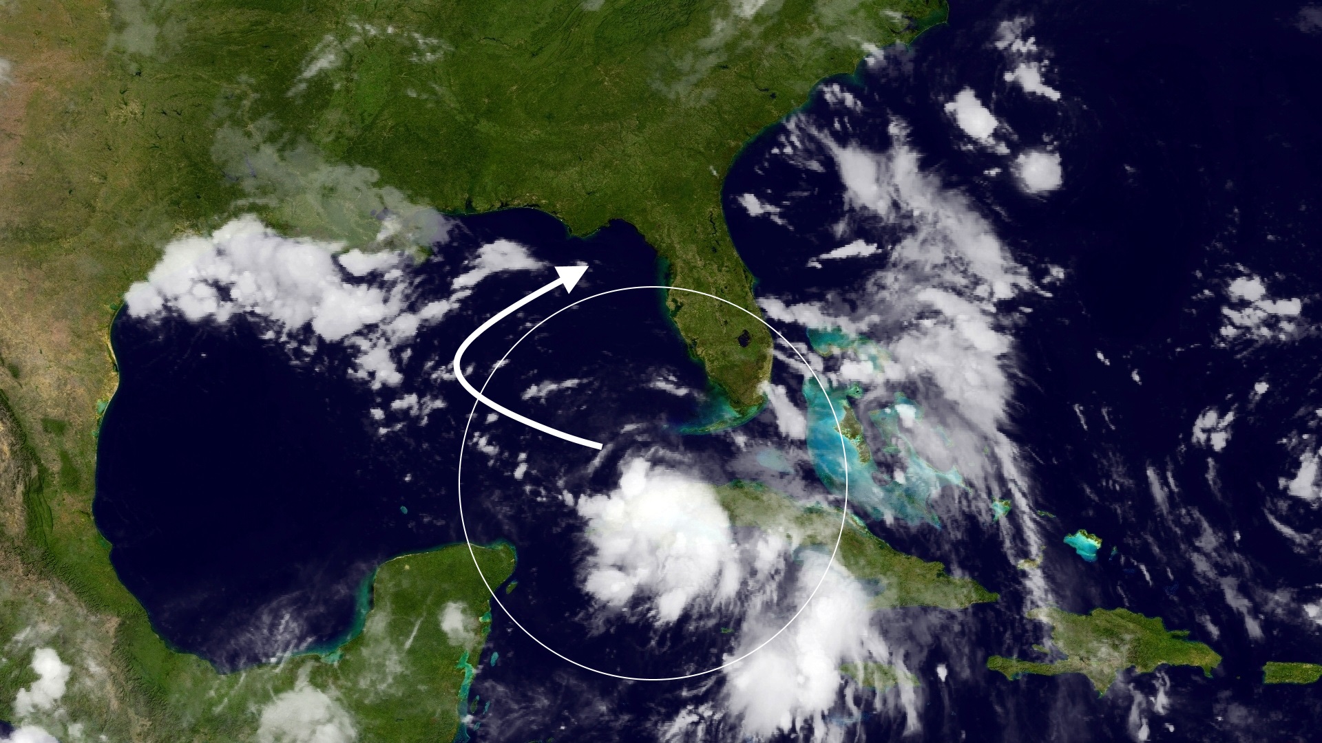
As I wrote in an extensive post on Sunday, the Atlantic tropics are heating up with Hurricane Gaston (not a threat to land) and two tropical depressions, including Nine, which entered the Gulf of Mexico. The former Invest 99L is likely to remain a tropical storm as it moves toward Florida’s west coast during the next few days, and could be a potent rainmaker for the state. No effects on Texas are expected.
Further out in the Atlantic, a vigorous tropical wave moving off the coast of Africa will have to be watched over the next week to 10 days as it moves across the Atlantic, toward the Caribbean Sea. It is a potential threat to the Gulf of Mexico.
Posted at 6:55am CT on Monday by Eric
Eric…Weather Underground shows 5 of 6 computer models tracking TD 9 N then NE back into the Atlantic…whatsup with the “BAMM” model that keeps TD 9 headed WNW to the lower Texas coast?
The BAMM is a simple statistical model that is best ignored.
I like that answer…thanks!
“Further out in the Atlantic, a vigorous tropical wave moving off the coast of Africa will have to be watched over the next week to 10 days as it moves across the Atlantic, toward the Caribbean Sea. It is a potential threat to the Gulf of Mexico.”
Not really, Eric. The 18z GFS shows the wave rebounding off E Fla. and going out to sea. No Gulf entry is depicted.
And the 12Z Euro supports what SkyGuy mentioned about the GFS.
Any thoughts, Eric?