The forecast for this weekend remains pretty much the same as I’ve been describing it all week. Please remember this isn’t a guarantee. Nailing the precise timing of rain events like this is an inexact science, but we can have decent confidence in this forecast.
FRIDAY
Breezy conditions, with strong southerly winds. Rains approach Houston from the west, perhaps reaching the western part of the metro sometime during the early afternoon hours, and the rest of the area during the mid- or late afternoon hours.
FRIDAY EVENING
Rains move in from west to east, starting with light rain, building to steadier storms by roughly 7 to 10 p.m. Most areas will begin to see some rain. Additionally the strong southerly winds could push tides 1 to 2 feet above normal. A coastal flood advisory is in effect.
FRIDAY NIGHT
Heavier rains move into central Houston just before or after midnight on Friday. It’s not clear whether the biggest burst will come over inland counties or closer to the coast. 1 to 2 inches are possible. Thunderstorms likely.
SATURDAY MORNING
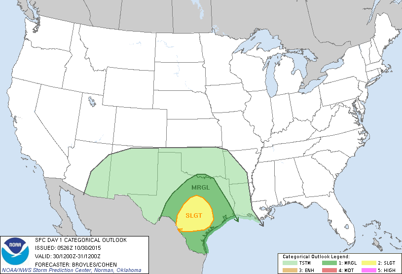
From sunrise to about noon heavy rain will again be possible, with accumulations of perhaps 1 to 2 inches. Thunderstorms again are likely, with potentially damaging winds or isolated tornadoes, but I don’t anticipate widespread, significant flooding.
SATURDAY AFTERNOON
Some clearing possible as storms move out of the Houston area from west to east. Heaviest rains likely ending.
SATURDAY EVENING
Most forecast models show the storms have moved off to the east. If it does rain, it’s likely to be scattered and light.
SUNDAY
Cooler, drier air moves into the region. Mostly sunny skies with highs in the 70s, overnight lows in the 50s. A great day for outdoor activities.
Posted at 6:50 a.m. Friday
Eric, thanks so much for the update. I love your heading with the shuttle. My hubby worked at NASA for a full 42 years and some of the software used on the shuttle he wrote. So we love all things space related. I love your new site!
Thanks Barbara!
Thanks for the updates Eric, glad to see you care enough to keep reporting the weather even though you have left the Chronicle. I enjoyed your series about NASA’s future awhile back so i am also looking forward to future posts about NASA and its future missions. Did you read the announcement yesterday that NASA has partnered with the Houston Airport System to assist with the SpacePort? Looks like Houston gets to hold on to its title of ‘Space City”, haha.. Kinda bugs me that people think NASA left… It never left and Johnson Space Center might as well be HQ seeing as it is the home of the Astronaut corp and Mission Control.. who needs the Shuttle when we have the SLS. Besides… wasn’t there a gap between Apollo and the Shuttle?? Gotta keep people on their toes!! Happy Friday.
Thank you, Spencer.
You can find all of my space coverage on Ars right here: http://arstechnica.com/author/ericberger/
Eric,
How concerned should I be regarding “potentially damaging winds or isolated tornadoes…” in the Hunters Creek Village area tomorrow morning? I am trying to keep our customers and vendors safe at a farmers market. Thanks for all your help. ~Tim
Ignore the question. Initially I asked because NOAA did not mention the severe weather. Now I see that they do and we will act accordingly. Thanks. ~Tim
Love the map. But what the heck do the abbreviations in the legend mean?
Marginal
Slight
Moderate
High
(chances of severe weather)