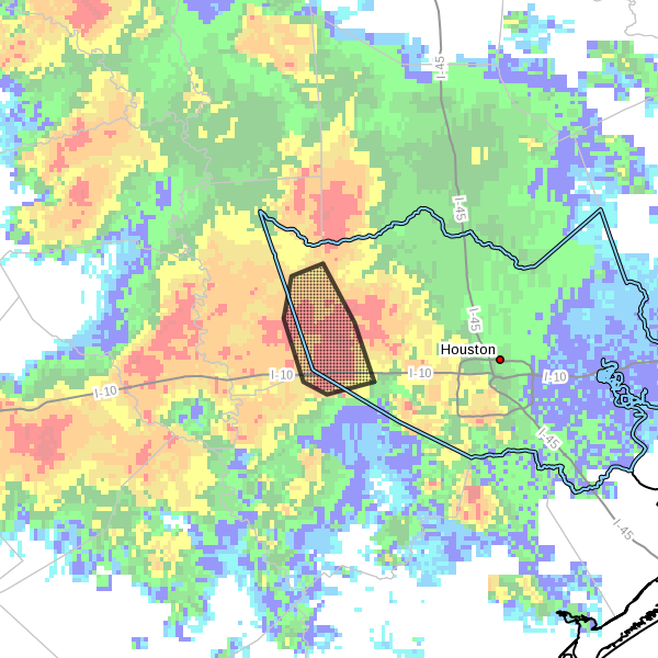
Fast-developing showers and thunderstorms have quickly brought 2 to 3 inches of rain over parts of western Houston this evening, and the National Weather Service has issued a flash flood warning for Katy and other parts of western Harris County. It is in effect until 11:30pm CT.
It appears as though this cluster of very heavy storms is moving steadily northward, and the Houston area may see a bit of a break as they clear the area.
However high resolution forecast models continue to indicate additional heavy shower development tonight across the Houston area, possibly again over western parts of the metro area as well as over Matagorda County. Given the surprise development of these heavy storms earlier this evening I would be hesitant to rule anything out.
What we do know for sure is that the atmosphere remains exceedingly moist, and the threat of heavy rainfall will not be far away for the next couple of days.
Posted at 9:50pm CT Sunday
I’ve got an early morning flight out of Bush. What do you think the drive up to the Airport from Clear Lake is going to look like at 5am?
No clue. Probably OK, but who knows.
Headed home from the UH campus at 11ish tonight and it was coming down heavy out here in Cypress. My rain gauge recorded 3.61in/hour at the house @ 9:44pm and 3.26in/hour @ 11:46pm.
Ground is already saturated with large trees in the road around the Fry Rd/Hwy 290 area.
8 inches of rain in Champions. Water seeping into my garage and laundry room. Cypress Creek is over its banks. I haven’t seen anything like this since Allison in 2001.