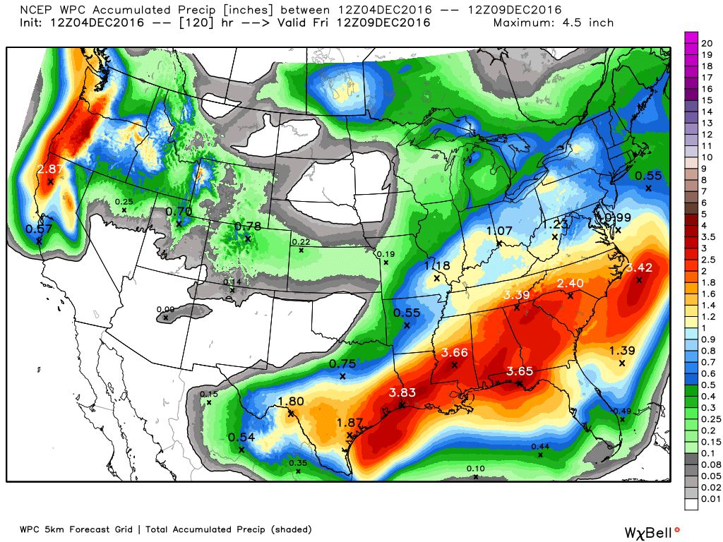
Good morning. The greater Houston region experienced very heavy rains on Saturday, particularly along the coast. With 7.68 inches, officially, Galveston recorded its single wettest day during any winter month, on record. Just inland in Texas City conditions were more grave still, with as many as 11 inches of rain falling. Parts of Galveston Island, Tiki Island, and La Marque all experienced significant flooding, and a Red Cross shelter was established in League City at Bay Harbour UMC, 3459 Deke Slayton Highway, for affected residents.
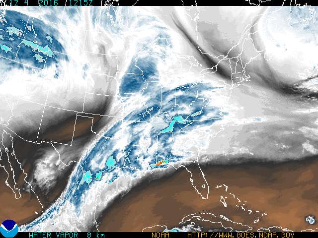
After a relatively quiet Saturday night, storms began moving into the Houston region a couple of hours before sunrise on Sunday, setting the stage for another wet morning. Due to lower pressures offshore, moist Gulf air will continue to flow inland at the surface, and at the same time in the higher levels of the atmosphere there is a pronounced flow of moist air from the west. The net effect of this is a water vapor “highway” flowing into Texas from the southwest, up through the eastern half of Texas and along the coast.
Conditions on Sunday
As the heaviest rains are likely to remain closer to the coast today, some northern counties, including Montgomery County, have been dropped from the flash flood watch, which remains in effect for the central, western and southern Houston metro region through at least Sunday evening. Conditions are obviously most concerning along the coast, in the regions that picked up 6 inches or more of rainfall on Saturday, and have sodden soils incapable of sustaining much more rainfall.
The storm system presently moving through Houston will probably drop an additional 1 to 3 inches of rain, with some higher isolated totals likely. Sometime this afternoon, the short-term models are suggesting something of a break in the rainy pattern which hopefully will allow for some drainage of creeks and bayous.
Monday
As the upper-level low pressure system itself moves across the region early on Monday, it appears as though the ingredients are in place for one more major round of showers and potentially some thunderstorms, probably during the morning hours. The threat here will be additional heavy rain and possibly some gusty conditions. Again, at this time, concentrations look heaviest along the coast but the forecast is fairly uncertain. Because of the potential for some street flooding, check the radar before making your morning commute.
Finally, a weak cold front should move through later on Monday to bring an end to the precipitation for a couple of days.
Cold outbreak
As we’ve been discussing, the first major Arctic outbreak of the season remains on tap for late Wednesday or early Thursday. This will very likely bring a freeze to outlying areas of the Houston region, and possibly the city itself.
Posted at 7:15am CT on Sunday by Eric
what kind of rainfall has Angleton gotten and should get today and tomorrow? every place is a lake here it seems.
Angleton got 5-6 inches on Saturday, and another 2-5 inches are likely between now and Monday night.
There’s a lot going on…and much to digest here.
Thank you for making it understandable.
That forecast looks good for the areas around and south of Gatlinburg, TN.
Water vapor highway. Great descriptor. As always, very informative.
Eric, You are my ONLY weather source for the Houston area. Your reports are always interesting, easy to understand and entertaining. Thanks for being here.
Thanks for reading, Jay.