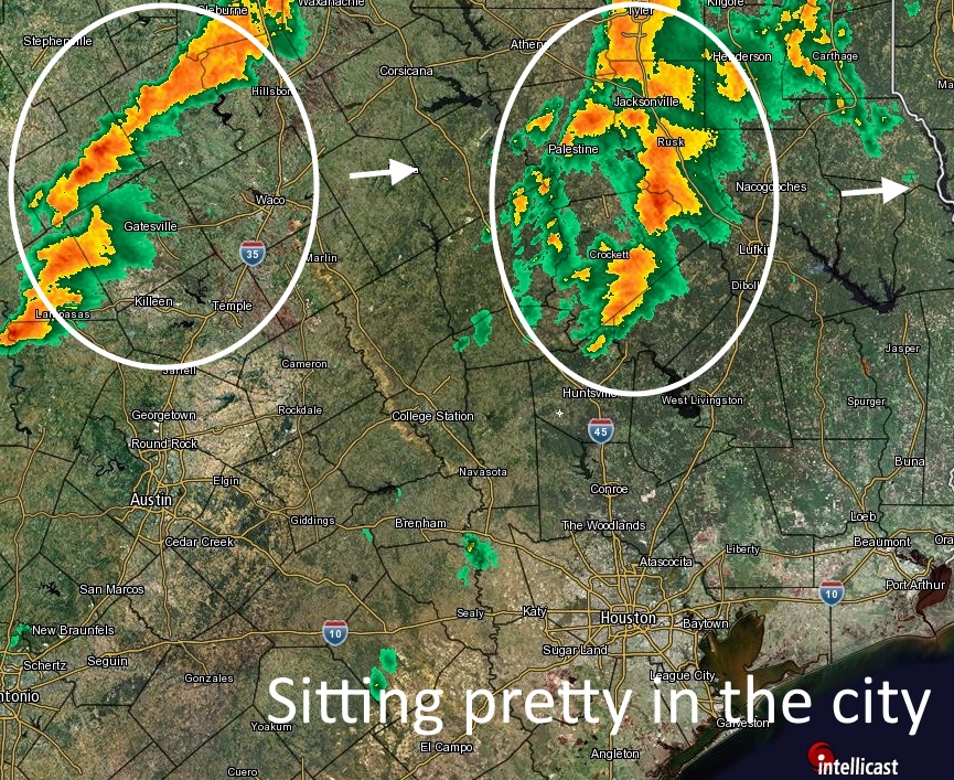
The concern about the potential for heavy rains and storms this evening appears to have been overblown as storms have remained well to the north of the Houston area. Although moisture levels are high, there just hasn’t been enough of an impetus to spur shower and storm development over southeast Texas.
TONIGHT
Given the quiet radar trends I think we can have some confidence that we won’t see the development of widespread rain showers over the Houston region through at least about midnight. That doesn’t mean we won’t see some isolated storms, including the potential for severe weather such as a tornado or two, but I don’t see the very heavy, widespread rain we were concerned about earlier. This is very good news because it cuts down on the potential for extremely high rainfall totals during this event.
SATURDAY
Confidence is also increasing that the storm systems which have developed over northern Texas could sag toward the Houston area early on Saturday morning, perhaps around sunrise. The most likely scenario is a fairly large complex of storms, bringing strong winds and the potential for hail or even a tornado, moving into Houston. If these storms progress quickly through Houston then most areas should only pick up a few inches of rain (if that). One concern is that the storms slow a little bit, and we still see some isolated areas getting 5 inches or more of rainfall in a few hours. In any case, there’s still the potential for some nasty weather across the metro area from the wee hours of Saturday morning through around noon. After that we should see some drying out. If you have plans later in the day on Saturday , or during the evening, I’d be cautiously optimistic.
With that said there’s no question the first half of this rain event has busted, so we can hope for something similar tomorrow morning. But I wouldn’t bet on it at this point.
SUNDAY
Rain chances will hang around on Sunday but I think showers that develop will probably be of a more scattered nature rather than a huge storm complex moving through.
MONDAY
At this point we could see another pretty healthy round of showers on Monday, but there won’t be quite as much moisture to work with so I’d be less concerned about the really intense rainfall rates that can cause flooding quickly.
Eric, I like your good news. But—-is this going to cause widespread damage like Wednesday’s storm event?
There is the potential for that but my guess is it won’t be quite that severe.
Amazing how inaccurate weather forecasters are…
But at least you will make a call
Yep, they’re the worst. (Hey. We did miss last night. I’ll give you that.)
“Confidence is also increasing that the storm systems which have developed over northern Texas could sag toward the Houston area early on Saturday morning, perhaps around sunrise. The most likely scenario is a fairly large complex of storms, bringing strong winds and the potential for hail or even a tornado, moving into Houston.”
I hope you’re talking about north to northeast Houston. I would not want to see 60mph winds citywide. Surely you’re not looking for anything like Wednesday, like Paul just asked you.
At this point, no, but I’m not ruling that out.
Are they going by the HRRR? That’s the only model that’s showing what you’re talking about, Eric. GFS/NAM doesn’t seem to agree with that. I should know, I’ve just looked at them on TropicalTidbits.com
PS: Pray to God that Paul Robison’s electricity stays on early Saturday morning, for me, okay? I know where he lives and we’ve been having a lot of utility issues out here.
Talk to me ASAP
Eric, don’t take any offense that this, but—–I personally think the model guidance is way too fast moving rain and storms into our area. If I were you, I’d consider that for Saturday’s weather, too.
Hi, Mr. B.
Thought you’d like to know. 00Z run of the HRRR shows only one tiny spot of rain over Houston. Most of the heavy/severe action seems to be the north of the area, if I read this thing right.
Here’s the link:
http://www.tropicaltidbits.com/analysis/models/?model=hrrr®ion=eus&pkg=ref_frzn&runtime=2016043000&fh=7&xpos=0&ypos=128
The HRRR has initialized very poorly for a number of runs now, so I would tend to discount it at this point for tomorrow morning.
What about the GFS and the NAM? I’ve looked at them myself and neither of them seem to be projecting anything potentially heavy or severe. If anything, those, too, keep the action all around metro Houston without bringing it into metro Houston itself.
http://www.tropicaltidbits.com/analysis/models/?model=namconus®ion=eus&pkg=ref_frzn&runtime=2016042918&fh=21&xpos=0&ypos=128
http://www.tropicaltidbits.com/analysis/models/?model=gfs®ion=eus&pkg=ref_frzn&runtime=2016042918&fh=6&xpos=0&ypos=128
Or is the Texas Tech model overruling all of them?
The RAP, Tx Tech and NAM (although its a bit north) all bring a line of showers/storms into the Houston metro area tomorrow morning around sunrise, and this seems consistent with the MCS over north Texas tonight. There is so much moisture this also seems plausible. Am I 100 percent confident in that happening? Of course not.
Do the models you mentioned show all of the storms as being severe?
No they do not.
I saw the RAP. Looks more like rain as opposed to storms. But then, that’s just me.
And here’s the WPC Loop of short range weather, for good measure. Note where it places the severe weather. Neat, huh?
http://www.wpc.ncep.noaa.gov/basicwx/bwxloop_ndfd.html
I wish the NWS would include how confident they are in a particular forecast–high, medium, or low confidence, for example. Sometimes the forecast is a slam dunk and other times it’s slightly better than a guess. I remember in the day prior to an Atlanta snowstorm a few years ago, when NWS issued a winter storm warning at around 6PM, then canceled it at 10PM, then reissued it at 2AM. This is an area where better communication between the scientists and the general public would be a good thing, I think.
Sometimes they do. That is something we will try to do on this site, on a consistent basis, moving forward.
Just checkin’ to see if I’m still “blocked”….. What ever I did or said, I’m sorry!! 🙂 LOL LOL
Ah HA! It was a glitch!! YEA!!! I still have the T-shirt tho’!! 🙂 🙂