Note: Today’s the last day of our fundraising campaign to support Space City Weather in 2017. You can help by buying a t-shirt, or making a donation. For businesses, we also have a handful of monthly sponsorship opportunities still available for the first half of the year. If you can help, Matt and I really appreciate it! Now, on to the forecast, and our looming encounter with Jack Frost.
Monday
The rain’s almost over, and most of us are probably good and ready for that. As previously noted, on Saturday Galveston set a record for daily rainfall with 7.68 inches, for any winter day, in any winter year, in more than a century of records. Texas City faced significant, widespread flooding. All told, here are the estimated accumulations for rainfall from Friday evening through Sunday for the Houston metro area.
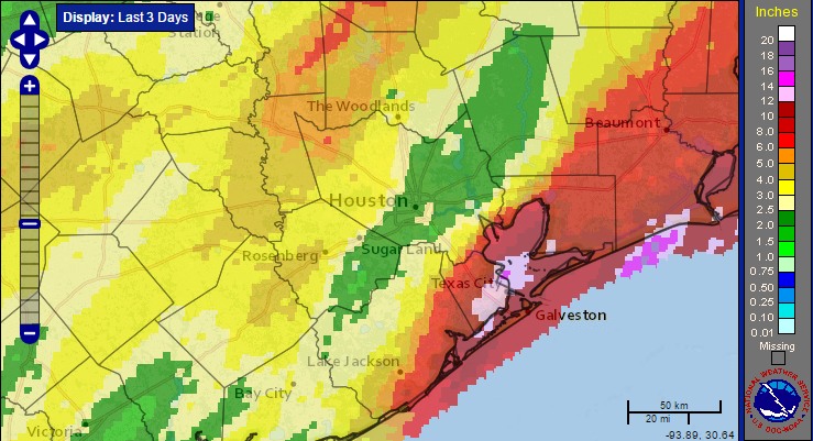
As expected one final round of showers is moving through the metro area this morning, but the rainfall rates are low enough with the fast-moving storms for them to just be nuisance showers rather than threatening any kind of significant flooding in the Houston metro area. Expect the flash flood watch for Harris and the coastal counties to expire at noon CT today. As the upper-level low pressure system moves out of the Houston area today expect the rain showers to end as well, drying out from the southwest to the northeast. For today, the severe weather chances have moved off to the east, to the Gulf regions of Louisiana and Mississippi.
Tuesday
This is going to be a great, mild day. As higher pressure temporarily settles over Houston we’re going to see partly to mostly sunny skies with highs of around 70 degrees, and morning lows of around 50 (colder inland, warmer closer to the coast). With relatively light winds this will be a nearly perfect early winter day.
Wednesday
It won’t last. Wednesday will again be a pretty nice day, with morning lows of around 50 degrees, partly to mostly cloudy skies later in the day, and a high of around 70 degrees. A chance of showers will come late Wednesday and early into Thursday as an Arctic front approaches the region. Any storms that do form should be fairly short lived because of the very dry air moving in behind the front.
Thursday and Friday
The timing for the front’s arrival is becoming more clear, with Jack Frost likely reaching northern parts of the metro area late Wednesday evening or midnight, and then moving through the Houston area during the early morning hours on Thursday, and then off the coast by or shortly after sunrise. In the wake of the front Thursday should remain mostly cloudy, breezy with a northerly wind, and cool—high temperatures likely won’t break out of the low 50s. Bring warm clothing and a jacket to work! Friday should be similarly cool in the low 50s.
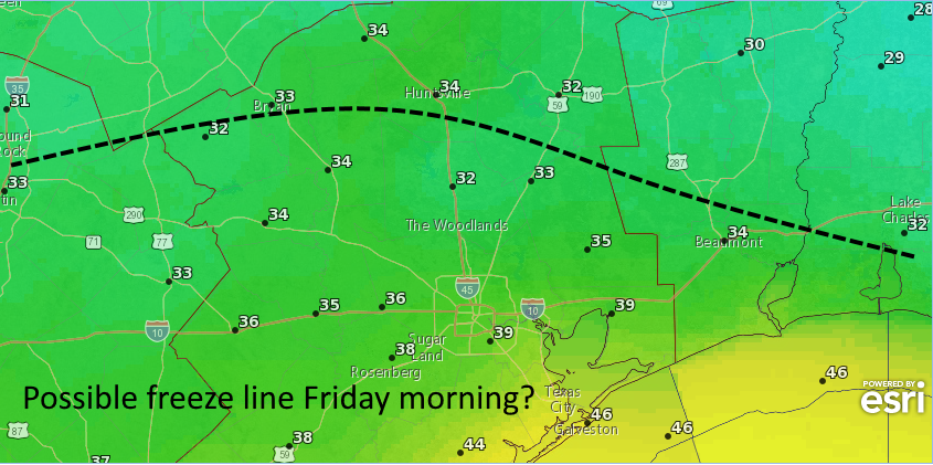
As usual when colder air comes, overnight low temperatures will be determined by cloud cover. Right now I’d bet on there being some clouds during the late-night hours Thursday, preventing most of Houston from seeing a freeze Friday, and holding temperatures in the mid-30s for inland areas, and lower 40s closer to the coast. But this is subject to change! If you’re in southern Montgomery County or other areas north of Interstate 10, keep an eye on the forecast if you need to protect outdoor vegetation. Temperatures on Saturday morning will likely be a degree or two warmer.
The weekend and beyond
Temperatures will begin to moderate a bit on Saturday, with highs climbing into the low 60s under sunny skies, and lows falling only into the mid-50s or so Sunday morning. As moisture returns look for the possibility of showers later on Saturday or Sunday. But we’re not looking at any kind of heavy rain, I suspect, just some very light showers. Highs should climb back into the low 70s by Monday or so, after which time the forecast is less clear in terms of another front.
Posted by Eric at 6:50am CT on Monday
The 3.2″ of rain we got in the beautiful downtown Ellington area agrees with the radar estimate.
Downtown Ellington … lol.
That’s BEAUTIFUL downtown Ellington (just like Burbank).
With temps in the upper 30s Friday morning, they might actually turn off the A/C in our office building. It’s still running full blast. Most of us are wearing our jackets inside now, and I think some of the natives are starting to turn blue.
“Jack Frost likely reaching northern parts of the metro area late Wednesday evening or midnight, and then moving through the Houston area during the early morning hours on Thursday, and then off the coast by or shortly after sunset. ”
Sunrise surely?
Don’t call me Shirley!
(I kid, thanks for the catch.)
I loved that movie!