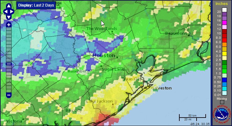
The Houston region received some much needed rainfall over the last couple of days, with generally 1 to 4 inches falling over the metro area. We were fortunate that the showers and thunderstorms delivered the rain not in a deluge but—for Houston—a more steady event. I have some visitors in town from Los Angeles, and they commented on how hard it rained Monday while driving through Houston. I had to inform them that this was pretty common in our city, and certainly not flood inducing. After Monday’s showers we can now look ahead toward some great mid-week weather with a strongish cold front tonight.
Tuesday
Temperatures are in the upper 60s across the Houston area this morning, and with a slight northerly wind it is not unpleasant. Conditions are going to be even more pleasant tomorrow. That’s because a stronger front (for May) will move through later today. This will bring a chance of showers, and a slight chance of severe weather (mostly high winds) during the afternoon and evening hours. For the most part rain accumulations should be a few tenths of an inch, if that, and should end by late this evening.
Wednesday
Inland parts of Houston have a good chance of seeing low temperatures in the upper 50s on Wednesday morning, and this is really quite a rare thing. The graphic below is illustrative of this. Before the city’s official weather site was located at Bush Intercontinental Airport, it was in downtown or south of downtown, and the average date of the last sub-60 degree night in spring came during the first half of May. However, after the site was moved north of town to Bush IAH, the last sub-60 degree night came in early June during the early 1970s. But the date of this last sub-60 night has since trended heavily toward early May in recent decades. (The average date from 1970 to 2015 is May 19th).
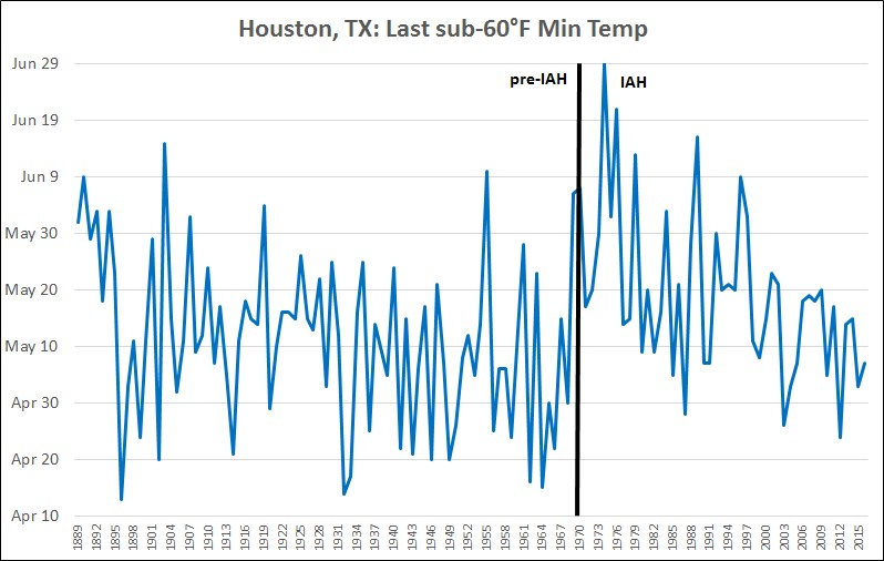
Therefore, if Houston hits 59 degrees or lower on Wednesday morning (May 24th), which seems likely for Bush IAH, it will be the latest day in May the temperature has reached the 50s since 1996, more than two decades ago. So this would be a real treat.
The downward trend in cool May nights seems pretty significant. Brian Brettschneider, a climate scientist who prepared the graphic for me, attributed much of dip to high urbanization (concrete) around Bush IAH, which does a better job of keeping overnight temperatures warm. This is definitely a factor, and there is likely the signal of climate change in the record as well.
Thursday through Saturday
Houston will warm up pretty quickly after Wednesday’s front, with highs rebounding into the upper 80s Thursday, and then likely lower 90s by the weekend. We can expect partly to mostly cloudy skies, and warmer nights in the 70s.
Sunday and beyond
A slight chance of rain returns by Sunday and into early next week, and partly to mostly cloudy skies should help keep temperatures in the upper 80s.
Thanks Eric, always love reading but the thing that stood out to me most this morning was that 1996 was over two decades ago?? Whaaat. Feeling older than I did 5 minutes ago. ?
Memorial Day has a pretty bad history lately around here. Hoping we can avoid a repeat.
“The downward trend in cool May nights seems pretty significant. Brian Brettschneider, a climate scientist who prepared the graphic for me, attributed much of dip to high urbanization (concrete) around Bush IAH, which does a better job of keeping overnight temperatures warm. This is definitely a factor, and there is likely the signal of climate change in the record as well.”
Does this paragraph make any sense? Is weather climate or not? Does one cool night send a climate change signal? If so, what is it? Please stick to weather. Please
Interesting contrast…May 20, 1996 has been the highest May temp in over 30 years in DC area.