Good morning. After another day or so of quiet weather we’re going to have to face another period of potentially heavy rain on Friday night and Saturday.
TODAY
Houston will see warm temperatures on Thursday, but how warm depends up the extent of cloud cover. If we’re mostly sunny temperatures could rise into the upper 80s, to near 90 degrees. If there are some clouds, or a scattered shower near where you live, temperatures will probably remain in the mid-80s. In either case, it will be a warm, almost-summer-like day.
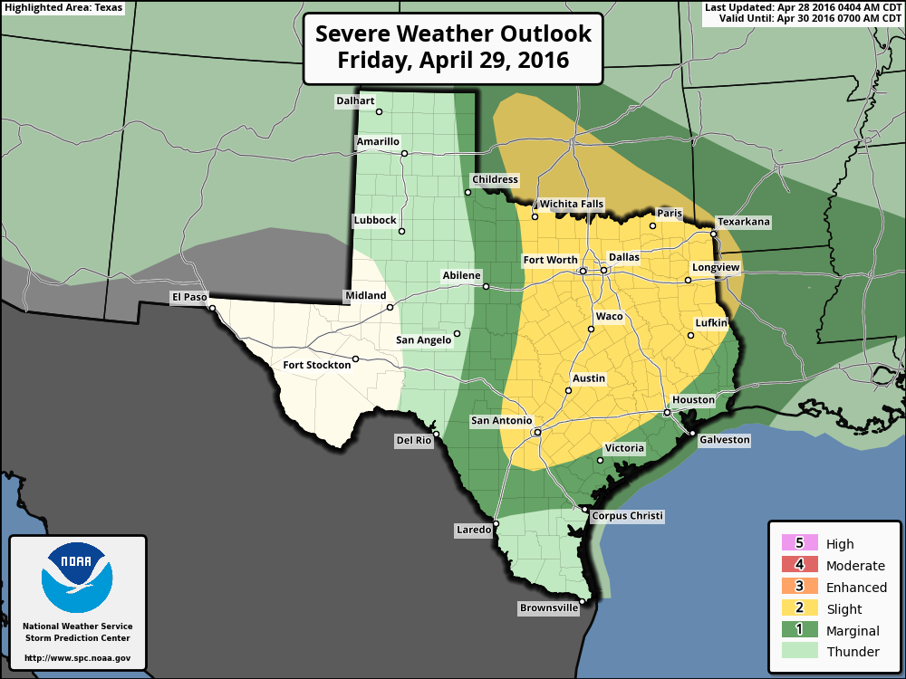
FRIDAY
After a slight chance of showers and thunderstorms developing to the north of Houston on Thursday night and Friday morning, we’ll see better rain chances later in the day. It is possible we’ll see some thunderstorms move in from the west later on Friday, during the evening hours. For now the west-northwest part of the metro area lies under a “slight” chance of severe weather (damaging winds, hail and possibly a tornado) on Friday and Friday night.
SATURDAY
I’m still expecting the best chances for heavy rain to occur on Friday night and Saturday. The combination of an approaching front to provide lift, slow motion and high atmospheric moisture levels will once again provide conditions favorable for intense rain showers. At this time we cannot say whether that will occur for sure, because sometimes these storms “hit,” and sometimes they “miss.” That is the nature of things. In this case I’d lean more toward a hit, with widespread rainfall totals of perhaps 2 to 4 inches (at best that’s an educated guess), and higher isolated totals. Some parts of southeast Texas may well see in excess of 5 inches of rain, which would create localized flooding at the very least, but it is not clear at this time where that will be. In any case, we’ll have to watch this system and its potential for additional flooding closely, and any outdoor activities on Friday night through Saturday night should involve checking a forecast before venturing out.
SUNDAY
Some rain showers will be possible on Sunday, but the storm system should be moving along by then. We should see partly cloudy skies and highs in the mid-80s.
NEXT WEEK
Rain chances will linger through Tuesday or so, when a cool front should arrive, making for clearer and slightly cooler weather for the second half of the week.
Posted at 6:55am CT on Thursday
Eric, do you think we will be able to get in a very important little league game in Richmond on Friday evening?
I’d put the chance of that at about 50-50, maybe a bit less.
Hi…love your weather reports! Can you predict how it will be on Saturday more specifically in the Mont Belvieu/Baytown area in the afternoon?
No, sorry, it’s hard to pinpoint where the heaviest rains will be. And I’d be lying if I tried.
Thank you.
How spread out over time will be the rainfall be? Are we talking five inches in two hours again? Or will the rainfall rates be much lower?
There’s the potential for high rainfall rates.
Not looking like a good day for our car club cruise to Galveston on Saturday. 🙁
Rescheduled. Woohoo!
It seems like we’ve been getting a lot of rain since you started this website? Coincidence?
We had a very dry winter … in our defense.
Eric – we seem to be in a pretty wet spring pattern. In your opinion, is this driven at least in part by the El Nino setup from this winter, perhaps just hitting us a bit later than was anticipated? While California has received some much needed rains over the past 6 months, I don’t think it has been the washout that people may have expected.
No El Nino is pretty weak, so I’m not pegging this month’s heavy rains on it.
I haven’t seen it mentioned here too often, but should Katy evacuate?
Hard to joke too much about Katy when it’s getting slammed by a foot or more of rainfall.
I hoped some of the more mature clientele had followed Eric here from the Chronicle, but apparently not.
When will El Nino end or suspend activity ? 2016 ?
Eric, what locations are in the northwest part of the metro that would be impacted by any severe wx?
Impossible to be that specific, Paul.