Houston’s warm weather continues, and while the daytime temperatures have been hot—97 degrees for three days in a row—the overnight lows have been exceptional. Let’s discuss the morning heat before jumping into the forecast.
Overnight lows
Houston has had the following “low” temperatures at Bush Intercontinental Airport since Sunday morning:
- July 3: 80
- July 4: 82
- July 5: 83
- July 6: 82 (as of 7am CT)
As my colleague Matt Lanza noted this morning on Twitter, this is a record-tying run of overnight warmth for Houston. Assuming the city’s low is 82 degrees this morning, Houston will tie for warmest 4-day average minimum temps on record (81.8 degrees).
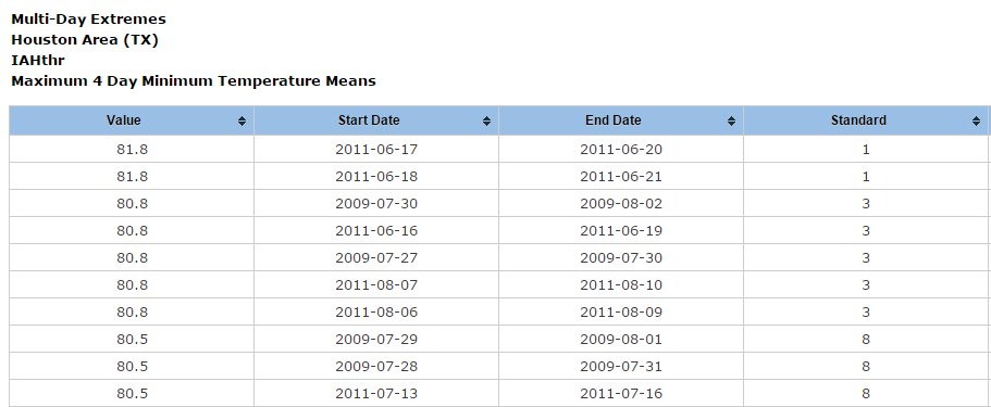
This run of early morning run of warmth is equaled only by that of the summer of 2011, which as we all remember was pretty horrible. We could actually break the record if tomorrow’s low is 81 degrees or warmer, which certainly seems possible. So if your morning runs or walks with the dog have felt miserable this week, now you know why.
Today through Friday
Unfortunately this warmth is unlikely to ebb. With high pressure dominating through Friday we should continue to see very warm days with highs in the mid- to upper-90s and lows around 80 degrees. Lots of sun. A heat advisory remains in effect for coastal counties.
Saturday and Sunday
The warm weather will continue, but at least a few late morning and afternoon sea breeze storms should sneak into the area as the high pressure retreats a little bit. For lucky areas these storms will provide some brief relief from daily highs in the mid-90s. Not expecting particularly wide coverage of storms.
Next week
The start to the work week looks fairly dry, but I am expecting Houston to transition to a slightly more wet pattern by Wednesday or so. At least it doesn’t look as dry without a suffocating ridge of high pressure. Highs should fall back into the low 90s, as well.
Posted by Eric Berger at 7:15am CT on Wednesday
I was curious if you all track allergens or do you know the best place to reference that for Houston? My allergies have been way worse than normal the past few weeks. Thank you for your awesome weather posts!!
Had a request for this yesterday and will write something up this afternoon or Thursday morning.
Thank you Eric!
Regarding allergens the City of Houston does post this information: http://www.houstontx.gov/health/Pollen-Mold/ .
Are these high morning “lows” due to global warming?
I’d attribute them to both climate change and development around the northern side of Houston, where the Bush IAH sensor is located. But in this case, warmer minimum temperatures is entirely consistent with what we’d expect from increasing greenhouse gases.