After three days of brutal, winter-like conditions, spring has arrived in Houston for another year. I kid, of course, but it sure is warm out there to start this week.
Today
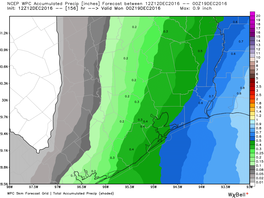
Lows have only fallen into the mid- to upper-60s across Houston this morning, and some light rain and fog has developed ahead of a weak cool front that’s now moving through the region. This front is likely to stall along, or just off the northern Texas coast. With light northerly winds most areas should see partly to mostly cloudy skies today, with highs of around 70 degrees. Lows tonight will fall down to around 60 degrees.
Tuesday
As the front meanders back inland, Tuesday should see temperatures in the low 70s, along with some scattered, light rain. Fog will be possible in the morning with this moisture before mostly cloudy skies later in the day. The weak front finally gets pulled back east, off the coast, allowing temperatures Tuesday night to fall into the upper 50s for inland areas, and lower 60s along the coast.
Wednesday
Yet another weak front should move through late on Tuesday or Wednesday morning, and because this one will move all the way through it should finally allow for some clearing skies, and a partly sunny day with temperatures of around 70 degrees. Wednesday night’s low temperatures should fall into the upper 40s north of Houston, and lower 50s closer to the coast.
Thursday
In the wake of the front Thursday should be mostly sunny, and cooler, with highs of around 60 degrees. Expect another cool night.
Friday and Saturday
We should begin to see the return flow of moisture on Friday, which could make for gusty conditions along the coast. Expect high temperatures on both days to climb into the lower- to middle-70s, with a pretty decent chance of rain as moisture levels increase. Saturday may not be ideal for outdoor activities, but I don’t have a whole lot of confidence in the likelihood of rain at this point.
Sunday
A stronger, winter-like front should finally arrive sometime later on Saturday or Sunday morning, bringing overnight lows back to around 40 degrees for most of the area. Winter, again.
Posted on Monday at 6:45am CT by Eric
When can we expect a Christmas prediction? I know it’s hard enough to get sufficient data 5 days in advance since the models flip/flop quite a bit, but you know we long for that Christmas forecast!!!
Thanks in advance.
Thanks for the suggestion! I’ll try to put something together this afternoon.
Hi Eric,
Could you please explain why we’re not getting any of that lovely polar vortex that the northern areas are getting? It is December, after all, and this bipolar weather absolutely sucks!! Do you think we might get other polars that loom in the future?
Thanks so much!
Texas, and especially Houston, is always going to see modified air because of the proximity of the Gulf of Mexico. So when its not blowing out of the north, we will see these warmer and more humid conditions. With that said, while this midweek Arctic blast is being shunted off to the east, Houston will receive a much more direct shot of cold air on Sunday, which will persist into much of next week.
Hi Eric,
We are heading out for a cruise from Galveston on Sunday the 18th. Looks like it will be nasty? Also, we are returning on the 26th. What are your thoughts about that far out?
Thanks!
Amy
Yep, Sunday will be gray and a little bit wet in Galveston, and conditions will be quite windy out of the north. But I suspect you’ll outrun the front eventually.
As for coming back, I’m planning to do a long-range post about Christmas for tomorrow.
I read your post first every morning. It’s a great planning tool. I don’t like to turn on TV for the weather because I have to hear all the bad news. (Ostrich syndrome). Space City Weather posts are more accurate and consise than most TV weather reports.
Thanks Nancy! That’s what we’re going for, to be a source of the weather news you need to know, but skipping the fluff.
Well it looks like the rough long 3 day winter is finally over and we can all break out the summer clothes again!
I was just curious, but do you believe that this winter we might have a hard freeze (low temps in the 20s, highs around near freezing) based on the way were going with the Arctic fronts that are coming in. By the way, you do very good weather forecasts for Houston
Thank you Emon. It is true that there is finally some very cold Arctic air for the region to draw upon, but right now the overhead pattern is not such that it is getting drawn down into Texas (it’s being shunted more to the east). I would bet against that changing this winter, but not with great confidence. The key times to watch will be about six weeks, from the beginning of January through the middle of February.