It looks like it’s going to be another one of “those” weekends here in Southeast Texas. We’ll have rain, storms, and potentially flooding to contend with, and all the while, we have a good deal of uncertainty still in the forecast. Here’s a short breakdown. I’ll follow it with an FAQ type section at bottom.
First, just a reminder: A Flash Flood Watch is posted for Houston and primarily the counties north and west of the city starting later today and going into Sunday morning.
TODAY
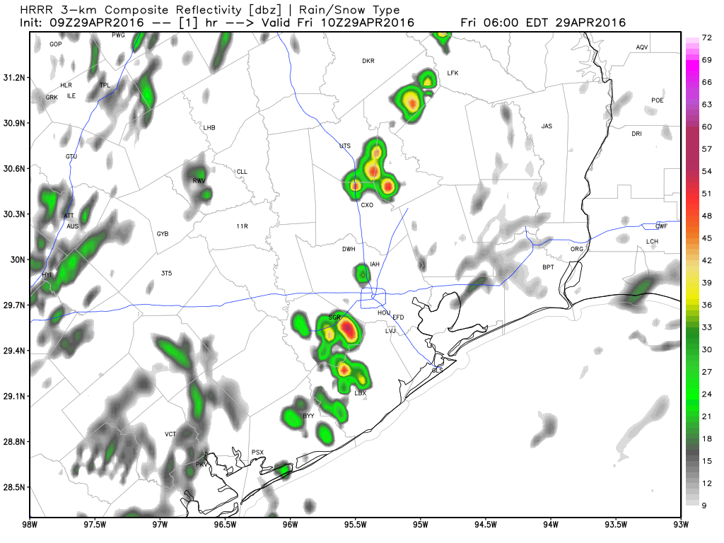
I don’t foresee a lot of issues this morning…if any at all. By mid-afternoon, storms should have started in Central Texas, along I-35 and points east. These will organize and spread east toward our area by late afternoon or evening. Storms this afternoon and evening will have the potential to be strong to severe. The main threats will be hail and damaging wind, and given how saturated the ground is, any sort of strong winds can be more problematic than usual. The tornado threat is low, though it isn’t zero (and as we sadly saw in Tomball the other morning, it doesn’t need to be a high risk or a strong tornado to be tragic, so please heed any warnings if issued). Obviously, our main focus will be flooding.
TONIGHT
This is where confidence drops and our risks for flooding begin to go up. I expect we will see repeated rounds of showers and thunderstorms around the region. It’s still a bit difficult to say exactly who will see the most persistent storms, but anywhere in the area around Houston (north, west, or even south of the city) stands the potential to see this happen. It’s simply too tough to say where with any specificity. We will update you on this again later today. But the Friday night timeframe is the one we’re most concerned with, namely because we’ll have a substantial amount of atmospheric moisture to work with.
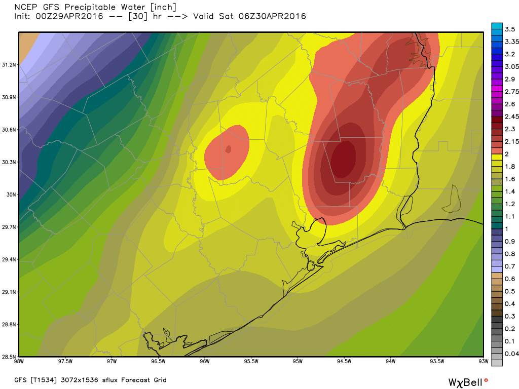
Usually once you get over 2″, you’re talking considerable moisture, which means that any thunderstorms can produce torrential rain. The concern is that a boundary of storms could sit over one area and tap into this moisture. Hopefully this isn’t what occurs, but it’s something we have to watch.
SATURDAY
As a weak cold front slips south of I-10 and the atmosphere begins to get tapped out, I expect we’ll see any showers and storms focus south of Houston, from about Galveston back through Victoria and begin to weaken a bit. While we can’t rule out some activity in and around Houston or up to our north, I think the most sustained issues will have exited after Saturday morning.
SUNDAY INTO MONDAY
Things may stay quiet for a bit here on Sunday, though we’ll definitely keep the chance of showers and storms in the forecast. As we go into Sunday night and Monday, the next trigger, in the form of another strong disturbance, will swing into East Texas, likely firing up another round of thunderstorms for most of the area, with additional heavy rain.
Once that clears Monday night into Tuesday, the front will finally make a clean sweep through the area, and cooler, drier air will move in. We may have some very pleasant days coming next week and a sustained period of dry weather, so there is light at the end of the tunnel.
QUESTIONS & ANSWERS
You’ve got questions, so we’ve got some answers. I’ve found that a lot of similar questions get asked during these events, so I’m going to attempt to answer some of the more obvious or common ones here.
I have an outdoor event Friday evening, Saturday, or Saturday evening: What do I do?
The simplest answer is to just stay tuned in. Saturday evening may be ok if everything can get out of here quickly enough, but there’s still too much uncertainty to promise you dry weather. I do anticipate at least some issues with rain and thunder tonight and tomorrow during the day (especially the morning). Exactly where and what time it hits is impossible to say with any certainty.
Will there be more tornadoes?
While I never like to rule anything out, the risk for tornadoes will be very low. But, as we’ve seen on several occasions since late last year, even if something spins up briefly, it can be damaging or tragic. So while the risk is more tilted toward strong winds and hail, if a warning is issued for your area (any warning…Tornado, Severe Thunderstorm, or Flash Flood), I strongly suggest you heed the advice and seek shelter. It only takes a brief second of severe weather to cause damage, injury, or worse. And with an already saturated ground, the amount of wind it takes to bring down trees may be quite a bit less than usual.
How much rain are we looking at?
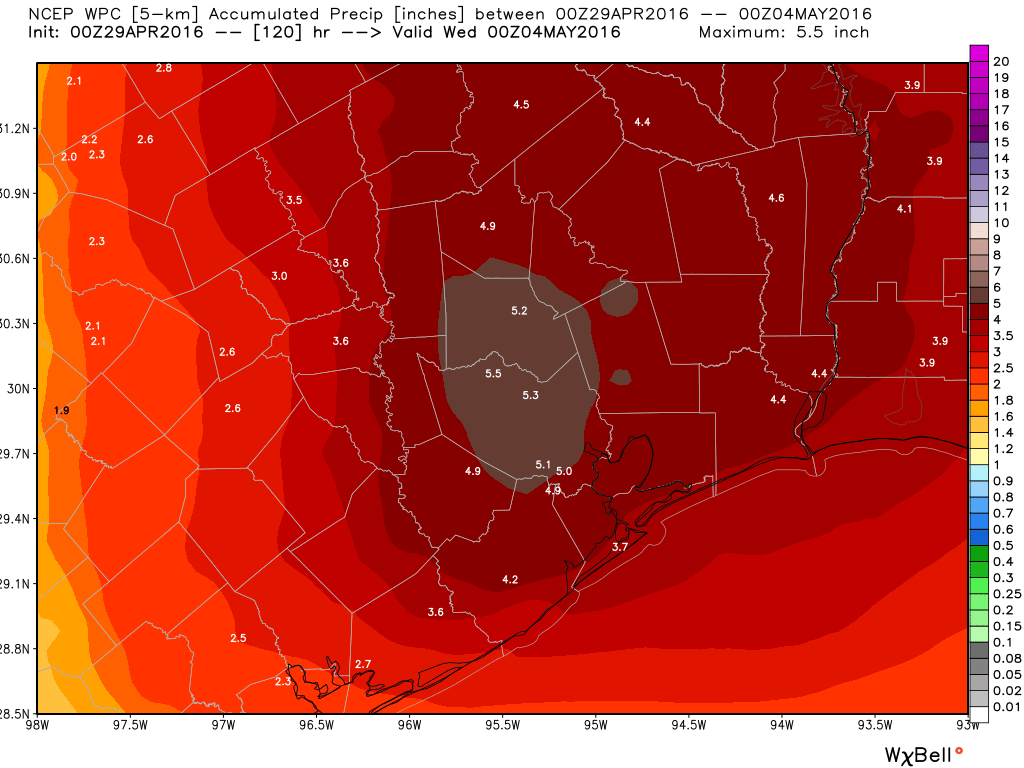
I suspect most areas will see 2-4″ of rain when everything is done by Tuesday. That said, there is ample atmospheric moisture available that if storms can reach their full potential, 2-3″ per hour rates may occur in spots. So while the 2-4″ average may hold, there’s likely to be a few bullseyes across the area that see 4-8″. Those shouldn’t be as widespread as the ridiculous rain we saw last week, but if they fall in the wrong places, they will cause problems.
Here’s the official NWS rainfall forecast for the next 5 days:
You’re sure this isn’t a repeat of last week?
It shouldn’t be. Last week saw a large swath of the region see exceptionally rare rain totals. This looks more like a typical Houston flash flood situation. The trouble is that the ground is already very saturated and some streams and creeks are still a few feet higher than normal. So while we won’t see widespread record flooding, we will likely be talking about street flooding, and yes, some areas may see more creek, river, or bayou flooding depending on how things shake out.
I have to travel this weekend. Will the rest of Texas see nasty weather too?
It’s likely there will be periods of storms across much of East Texas the next few days. Austin and San Antonio are included in this, though I don’t expect serious issues there. The main areas of concern are from just west of Houston to about Lake Charles, LA north to Texarkana.
Hopefully this answered most people’s questions. If it didn’t, let us know in the comments, on Facebook, or on Twitter. Some other links to follow and bookmark?
Matt’s Twitter account is usually active during active weather in Houston.
Jeff Lindner, the meteorologist for Harris County Flood Control, is a must-follow.
The Harris County Flood Warning System interactive map can update you in near-real time on bayou levels and rainfall totals.
As usual, thank you for the concise analysis.
I have an outdoor event planned for Sunday starting at 2:30. What is the outlook?
Eric, has there been something in particular that has caused the atmosphere to pull in and dump so much water over the last couple of weeks? Was it just bad luck on how and when the systems have moved?
Mostly a factor of being near the jet stream and a storm track setting up to bring these upper-level low pressure systems into Texas.
Thanks. Is this pattern expected to persist?
We will see a chance of rainfall through about Tuesday, after which a front should happily dry us out for awhile.
We plan to be in Galveston for the weekend. Do we need to worry about hail and flooding there?
Probably not, but rain could definitely put a damper on festivities.
Thank you, you are the BEST!! I can rely on you when I really want straight facts.
You guys are just the absolute best. No BS just good info. Thanks for everything
Supposed to drive to Austin around 5 or 6pm tonight. Should I hold off?
Check the radar about 3-4 pm and then make your decision from there.
Thank you. You’re my go to weather source.
What about Meyerland? Should we be putting things up high again? This whole thing makes me ill to think about again.
Thanks – love the no BS reports.
I wouldn’t go there yet.
Thanks! Please post back if you change your mind. 🙂
Your reports are simply the best!! Congratulations!!