As promised, here’s another look at the tropics as we near the peak of the Atlantic hurricane season. Like with our post on Monday, today we’re going to focus almost exclusively on a tropical wave known as Invest 99L, rather than the rapidly strengthening Tropical Storm Gaston, which likely will become a hurricane later today or on Wednesday. This is because Gaston is unlikely to threaten land, and the same unfortunately cannot be said for Invest 99L.
What is Invest99L?
For now it’s a tropical wave nearing the Lesser Antilles. The system has had some difficulty organizing up until now because of dry air, which has helped to limit the development of thunderstorms. Here’s the satellite presentation from about 1:45pm CT on Tuesday afternoon.
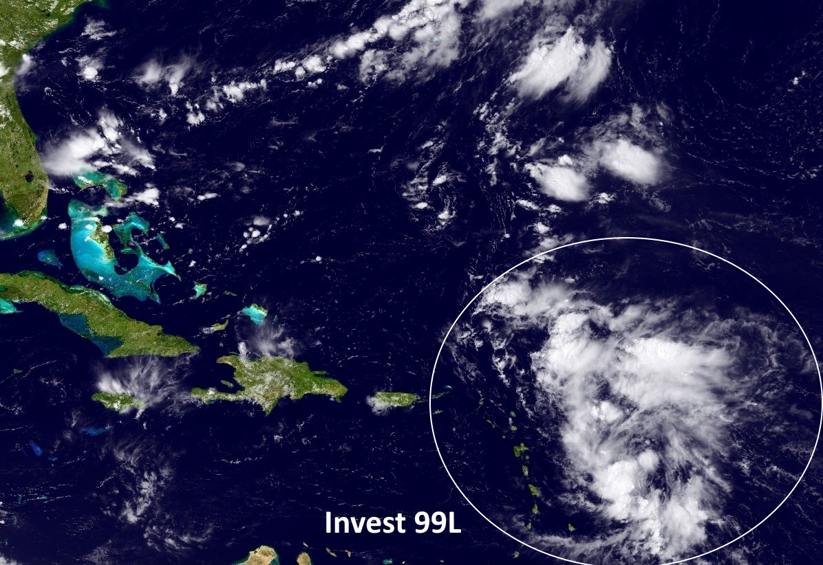
The system isn’t impressive—yet. The National Hurricane Center gives it a 60 percent chance of becoming a tropical depression or storm during the next five days as it moves to the west-northwest toward the Bahamas. The GFS model is not impressed with the system’s chances, essentially washing out the storm over the Bahamas. And that might be the end of the story, but for the fact that the European model, which has a better track record with these kinds of systems, does not dissipate 99L. Rather it brings a hurricane toward Florida this weekend, across the Sunshine State, and into the eastern Gulf of Mexico.
So what is going to happen?
There are two big questions about what is going to happen to this system, whether it develops, and where it goes thereafter. I’m inclined to think the system has potential, because despite the ragged appearance in the satellite image above 99L has shown some deep convection during the last 24 hours, a sign more development may be coming. In addition, in a couple of days it should reach an area with only moderate wind shear.
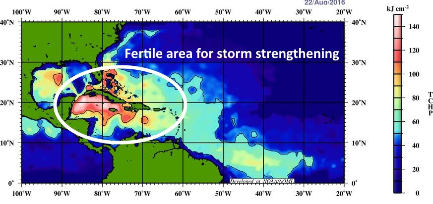
What concerns me is that the system, if it moves toward southern Florida, will find an area of not only warm waters, but heat that runs deep. That means that as the system churns up water from below, this upwelled water won’t be significantly cooler, which can weaken a tropical storm. Instead, the “tropical cyclone heat potential” is quite high. (Anything above a value of 80 is considered adequate for rapid strengthening).
So it is at least plausible that Invest 99L will become a tropical storm or a hurricane, with the potential to intensify further. What happens after that?
Track for a potential Hermine
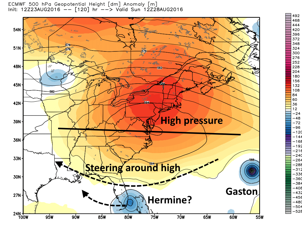
As discussed on Monday, a fairly strong ridge of high pressure is likely going to prevent this system from moving northwest. While there remains some question as to whether the system would get squeezed to the northeast (following Gaston), or pushed due west, right now it seems more likely the system will move west. The European model (shown below) shows Hermine moving across southern Florida next Sunday morning.
Once in the eastern Gulf, which is warm too, Hermine might have more of an opportunity to strengthen. While we can’t rule out a continued westward progression toward Texas, I’d still bet against this system making it all the way across the Gulf of Mexico. More than likely it would turn north before then, possibly targeting somewhere from Louisiana to the Florida Panhandle.
Here’s the bottom line: Expect to hear a lot about this storm during the next week. There has not been a hurricane in the Gulf of Mexico in nearly three years—a drought that has not occurred since at least 1850. Therefore a lot of people are going to get excited about this system. And I will not lie, it definitely has the potential to cause serious wind and rain problems for the Gulf. It is a threat. But at this time it is just a tropical wave, and there’s a chance it may not develop at all. So we’ll continue to watch, and not hyperventilate.
Posted at 2:45pm CT on Tuesday by Eric
That’s for the analysis. So much better than trying to get it as a soundbite on TV snippet. Keep the updates coming.
One other question- Why the name “Invest 99L”? seems random, is there an article on how waves are named?
https://en.wikipedia.org/wiki/Invest_(meteorology)
I’m moving to Katy next month. Should I…oh nevermind. I’m not quite there yet. Lol
Definitely lucked put picking this week instead of next to be in Ft Lauderdalw. Thanks for all the info.
This storm became a thing literally twelve hours after I booked a week long trip to Orlando for meetings and such.
Eric, the 18z model run of the GFS sent 99L all the way to SE Texas! Did you see it?
Most of the ensemble members did not, but definitely worth watching.
I saw what Paul’s talking about, too, Eric. Time for Houston to go on red alert!
Definitely not time for red alert. Time to watch closely, however.
I think we should call it Hurricane JJ Watt, since it’s #99. I wouldn’t want to mess with that one.
Eric, I’m a little scared of the 12Z HWRF. Take a look and see if you don’t see a resemblance to a certain “R” storm from 2005.
Good info….keep it coming.
We’re due a storm…not based on anything scientific…but I’ve lived on the Gulf Coast my whole life (with the exception of my military tour) and going this long without a storm is not the norm.
i live in Galveston County and any thing that is even a tropical storm mentioned scares me after hurricane Ike and i feel sorry for all those being hit by Mathew
As we’ve been saying there was, and remains, nothing to worry about.