As of midday Wednesday, we’re starting to feel pretty good about the chance of Houston avoiding significant flooding from the remnants of Tropical Storm Imelda. We’re not entirely in the clear, to be sure, but the threat is shifting east away from the metro area. First of all, let’s take a big picture look at the radar at Noon.
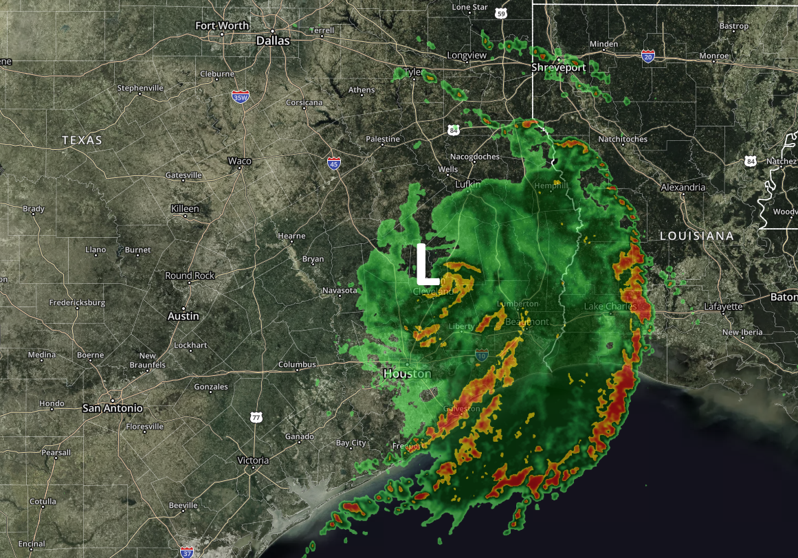
As you can see, Imelda’s remains are producing a very broad circulation, with several distinct banding features from along the Texas coast to well into Louisiana and northeast Texas. Houston residents will also take note that these strongest bands are generally moving away from the metro area.
Based upon the latest modeling trends, we expect this trend to continue today. While the Houston metro area may see an additional 1 to 4 inches of rainfall over the rest of Wednesday and through Thursday (especially to the east of Interstate 45), the threat of sustained, heavy, and flooding rainfall is diminishing. We can see this based upon the HREF model output, which is an ensemble of several models that attempt to predict smaller-scale convection during rainfall events. Of all the models we’ve looked at so far during this event, the HREF has arguably done the best. Here is its output for now through Thursday.
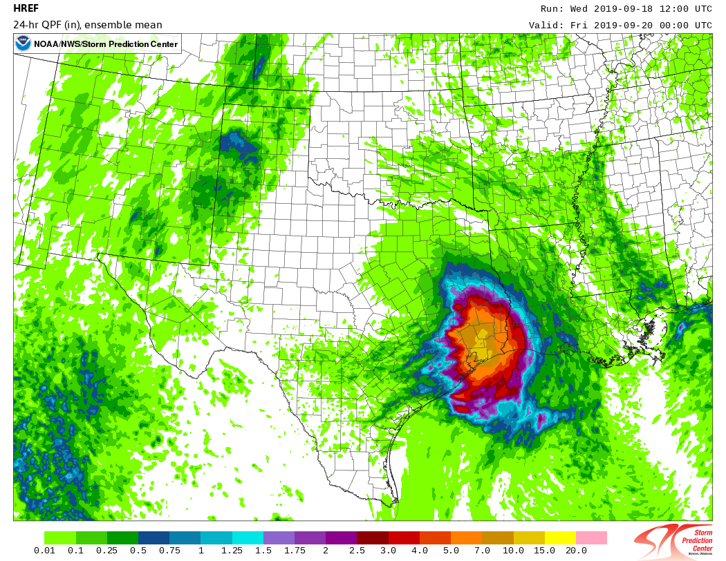
The bottom line is that right now we expect the Houston region, including hard hit areas in Brazoria and Galveston counties, to generally see improving conditions from here on forward. Intermittent storms may well pop up, but right now, we anticipate that most areas can safely return to business-as-usual activities. For areas east of Houston through Beaumont, however, we definitely have concerns about ongoing heavy rainfall, and will continue to monitor that situation.

There’s a lot of nervous folks out here in the Lake Houston area. Do you think the majority of the bands will be east of us?
Bravo!
Great work as always gentlemen!
Would the area between Hobby and Ellington be one of the areas of concern?
Mostly for the better, but I’ve gotten very little rain from this event here in the Fry and Ten area. Maybe a half an inch. Cooled things down and helped the landscape a bit but mostly much ado about nothing.
Not complaining seeing how a good bit of the rest of the area has fared.
Do you include the Clear Lake/Southeast suburbs as “Houston” or is Houston referring to everything inside the beltway?
Thank you Eric and Matt for briefing us on Imelda!
Stay safe everyone!
Boy, the West-side that was on the verge of drought and really could have used the rain got hosed on this one. Seems like there’s a dome over the north side of 10 past Hwy 6 that keeps all of the rain away.
No doubt. While I’m glad we didn’t have a flood out here, I was hoping to add about 4-6″ instead of .50″ of the wet stuff.
Not just on the north side of I-10! I’m a few blocks south of 10 off Fry Road and storms frequently split and go east and west of me. Frustrating, isn’t it?
👏👏👏👏👏
Lake Houston area also – close to Liberty County line. When will this next round really ramp up? Trying to decide if I should leave work (I-10/Campbell) early to get back home before it hits hard.
I know we are not thru with this, but what are the expected impacts (if any) of the two new systems headed thru Caribbean to Gulf? If it’s bad news, I want it now so I can plan…………
Yards are still crunchy and plants are still thirsty in areas that got less than an inch of rain by Wednesday morning, including parts of Katy, Tomball, The Woodlands and Conroe. Can’t say the same about Beaumont!
Thanks guys – it’s so nice to be able to count on your predictions and explanations.
Wonder what’s up with nasty bit of green near west Texas and northern Mexico. Should we queue the Jaws theme?
Traveling to La tomorrow, do you think the rain will be manageable?