October ended as an usually hot and dry month. Eric covered this a bit yesterday, but weather data from Houston’s Bush Intercontinental Airport shows that 25 out of 31 days were warmer than average, with a measly 0.14 inches of rain recorded for the month. By the end of October, the heat and lack of rainfall produced drought conditions in the eastern third of Texas.
The jet stream
Figuring out why our weather has been so warm starts with analyzing the jet stream. The image below is an upper-air map, showing the state of the atmosphere at 250mb (about 30,000 feet above the ground, or a just above the peak of Mount Everest).
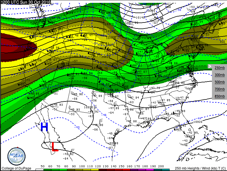
The colored areas are regions of fast-moving air aloft that flow across the continent, like a river of air. Red regions have wind speeds in excess of 150mph! In any case, note how far north the strongest current of winds is—far away from Texas.
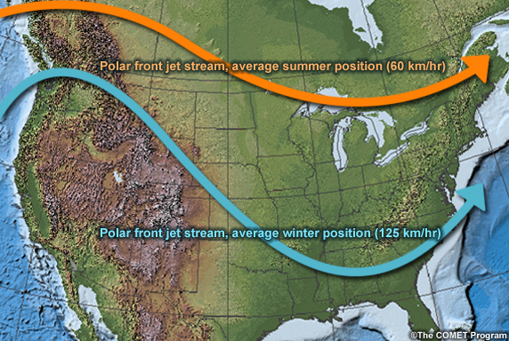
I have to give credit to my undergraduate meteorology adviser for this point, but if you asked most people who studied meteorology when the map above was made (without looking at the date), most would definitely not think it was from October. Most meteorologists would assume this was a map from July or August. See the graphic here:
However this year the polar jet stream has remained anomalously far to the north for the middle of fall.
So what does this mean?
The jet stream typically signifies the boundary between warm, southerly air, and cool, northerly air. The notorious ‘polar vortex’ emerges when the jet stream dips well into the U.S., bringing frigid arctic air with it. It also serves as the driver for most mid-latitude cyclones and cold fronts that move through the continental United States. When the jet stream remains at a high latitude, it prevents cool arctic air from pushing down into the U.S., and limits the southern extent of frontal systems. A stagnant jet stream also allows areas of high pressure to persist, which also encourages warm temperatures.
Luckily, the sun is lower in the sky and days are shorter in the fall, so we won’t see any 100 degree heat waves—at least, not in our area. However, across the country, this pattern is creating unseasonable warmth for everyone. It’s yet another instance of increasing temperatures across the country and the globe. This year alone, over 20,000 record high temperatures were broken. Until this pattern breaks (which is coming later this week…for us, at least), expect many more high temperature records to fall in 2016.
Posted at noon CT on Tuesday by Braniff Davis
If the jet stream isn’t working out, maybe we should go back to the prop stream?
Would that I could figure out how to put a slow-clap emoji in here. Bravo.