After heavy rains Saturday, and almost nothing Sunday, what can be expected for today? Let’s discuss that in a moment, but first lets look at our cooler-than-normal May.
Every year we generally get warm, dry Mays or, if the storm pattern is more active, cooler and wetter Mays. This month has obviously been the latter. So far this May has been nearly 3° cooler than normal. Moreover, consider these high temperatures over the last eight days: 80,73,83,81,70,80,82 and 85 degrees. Normally at this time of year we should be edging into summer.
A graphical representation shows warm/dry May vs. wetter/cooler May dichotomy nicely:
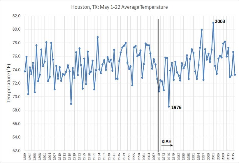
So in Houston, in May, it’s usually a matter of picking your poison: Do you want it hot and sunny, or cooler and rainy.
One other notable feature is that, so far, Houston’s hasn’t recorded a 90° day this year. Houston has only made it through May without hitting 90° in just 11 years of more than 120 years of records: 1895, 1897, 1918, 1919, 1931, 1936, 1950, 1957, 1965 and 1970. (Thanks to Brian Brettschneider for the data) So it’s been 46 years since the last time. We’ve got nine days to go.
TODAY and TUESDAY
Forecasters largely failed this weekend with the active storms on Saturday, and Sunday was a surprise too when almost no activity developed during the afternoon and evening hours. So take the forecast for today and Tuesday with a grain of salt.
The radar is quiet this morning, but fairly high moisture levels remain across the area and if temperatures heat up into the mid- to upper-80s we will probably see at least some scattered thunderstorm activity both days. There’s enough atmospheric instability such that, where these thunderstorms do develop, severe weather including hail and brief, damaging winds, could also occur. Chances for any storms will be highest during the afternoon and evening hours. Highs will be in the mid- to upper-80s with lows in the low- to mid-70s.
WEDNESDAY
Right now it appears high pressure will settle in for Wednesday, bringing mostly sunny skies, very low rain chances and allowing temperatures to get to near 90°. This is our best chance for reaching that mark this week.
THURSDAY
Thursday will probably be another one of those days with a sunny morning and then a chance of afternoon thunderstorms with daytime heating. Highs likely will be in the upper 80s.
FRIDAY
An upper level storm system will approach the area, setting the stage for potentially heavy rain and widespread thunderstorms. Forecast models indicate the best rain chances will come Friday evening and during the overnight hours. Some severe weather will also be possible. We’ll have to watch this event as we get closer to better parse the details.
SATURDAY and SUNDAY
Hard to have much confidence in the weekend forecast, but I’ll go with highs in the mid- to upper-80s and chances of afternoon thunderstorms. Sunday looks like it may have more sunshine than Saturday.
Posted at 6:55am CT Monday by Eric Berger
I saw yesterday the 3 month outlook shows below average temperatures expected for us, it would be pretty nice if this continued. I can remember recent years reaching mid and even upper 90’s in May!
Agree it would be nice. We’ll have to see if those forecasts hold true, however.
In addition to weather forecasts, it would be great if you could give flight path forecasts as well, and no, I’m not being silly. Imagine my surprise when I was transferred to Houston in 2012 to discover that due to Houston not having a noise ordinance, planes traveling to IAH or Hobby fly directly over neighborhoods, whether you live in River Oaks and have SW jets heading to Hobby or the larger jets over Champions heading to IAH. I have never invited friends to visit me here as I am too embarrassed about living in a flight path, and naturally I never know when or if I can enjoy being out in my pool due to jet traffic. Over the years of living here, sometimes flights are few and far between, sometimes they are every day for weeks on end. So, if flight paths really are affected by weather as I have been told, could you offer me any advice on how to predict if I’m going to get any plane activity on any given day? Seriously, it would be so helpful!
Jeneane, let me jump in here if I may. Wind direction generally dictates which landing patterns ATC uses to bring traffic into IAH. There are three runways (08/26 R and L and 09/27) that are almost always used to land arriving traffic. All three of these runways are oriented east-west, parallel to each other. Generally speaking, when our winds have an easterly component, the arriving traffic will be routed in to the airport from the west, which is when you see them over the champions area. During the summer months, winds will pretty much prevail out of the south, it just depends on whether they are southeast or southwest. Of course, if there are big storms along the approach paths, ATC can change the landing direction to keep aircraft on approach away from the severe weather.
Depends on which airport you live near and if you live on final approach or an arrival or departure route. The active landing and departing runways are based on the current winds. Pilots like to takeoff and land into the wind as it uses less runway and is safer.
Prevailing winds in Houston are from the S/SE so most times the active departing runways at KIAH are 15 L/R which takes them south of the airport and usually a right turn over 45 and BW8. The favored arrival runways are 27 and 26R/L which brings arriving aircraft over Kingwood and Lake Houston area across 59 into those runways. If there is a stronger easterly wind component, they will reverse arrivals to come in the opposite direction 8L/R. This would bring aircraft over the Cypress/Spring area. Runway numbers are determined by their magnetic compass direction. 8L/R is on the heading 080 which is almost east.
I would start by looking at your satellite location on Google Maps and determine if you are lined up with any of these runways. If you are, then you can find out what the active runways are by calling KIAH ATIS at 281-209-8665. It is just a recording that gives airport information to pilots. It repeats over and over, so just listen until you hear the “Active Landing” and “Active Departing Runways”.
If winds are coming from the south, Hobby traffic will be making approaches over the area between the Galleria and downtown. I’ve been in the area for years and the planes don’t bother me. Be glad you don’t live south of Hobby where the takeoff noise is much louder.
I know its a bit out there but Free Press Summer Fest is June 4-5. Any indication of how the week leading up to and that weekend looks?
I suspect we’ll be into a warmer, mostly sunny pattern by then. But hard to say for sure.
It seems you have changed the URLs for your site–each day has it’s own page? This is going to make it hard for us to bookmark!
Sorry…”its” own page
It should be OK if you just bookmark spacecityweather.com
Eric, I think the best chance of severe weather is probably going to be in Northeast Texas, likely the Dallas/Ft. Worth region. Houston may be safer than up north. Right?
I agree.
Eric, I was just on the phone with a friend of mine at the League City met office. He says that they think (at this time, at least) that the bulk of the convective energy & upper diffulence will remain up in northeastern Texas/Arlatex. That would suggest heavier rain and stronger thunderstorms in that region as opposed to SE Texas.
I agree, and wrote as much this morning.
“An upper level storm system will approach the area, setting the stage for potentially heavy rain and widespread thunderstorms. Forecast models indicate the best rain chances will come Friday evening and during the overnight hours. Some severe weather will also be possible. We’ll have to watch this event as we get closer to better parse the details.”
Friday in Houston. SHTF day!