Good morning. One more gray day before the Sun returns. We’ll also see better chances for heavy rain next week.
TODAY
Light rain showers are moving into the region from the southwest, and I expect that by this afternoon or evening most parts of the Houston area will see at least some mist, if not light precipitation. Nothing to write home about, though, and highs will struggle to reach 50 degrees.
SUNDAY
The aptly named Sunday will see the return of the Sun. Finally. After a cold start at about 40 degrees, highs will climb into the mid-50s. Should be a really nice day after what we’ve been experiencing.
MONDAY-TUESDAY
Partly to mostly sunny skies and cool days in the 50s will remain the order of the day through Tuesday afternoon or evening. Tuesday morning will be quite cold under clear skies, but I don’t think most of the Houston metro area will reach freezing temperatures. We’ll at least be close, however.
WEDNESDAY-THURSDAY
A good chance of rain returns during the middle of the week, as a moist flow off the Gulf of Mexico resumes and highs climb back into the upper 60s and possibly 70 degrees by Friday.
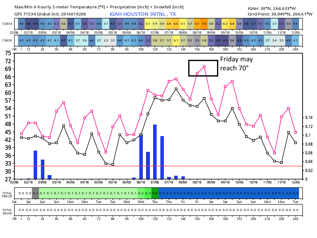
Right now Wednesday night could be a fairly wet one, with 1 to 2 inches of rain possible as well as isolated thunderstorms. Still a fair amount of uncertainty at this point, but I wouldn’t be worried about any potential flooding.
NEXT WEEKEND
It’s a long ways off, but at this point next weekend looks pretty nice in the wake of a modest cool front, with potentially sunny skies and highs around 60 degrees. Let’s hope that pans out.
NOTE
Enjoy the rest of the holiday weekend. I’ll return on Monday.