With Cindy in the rear-view mirror, we’re tracking back to a more standard but unsettled summer weather pattern. No serious trouble is expected the next few days, but if you’ll be outdoors this weekend, you’ll want to have a rain plan. Let’s break it down.
Today
The main story today is going to be unpleasant temperatures. Highs should reach the lower or middle 90s in Houston and the upper-80s at the coast. But in the wake of Cindy, humidity is going to be oppressive. Dewpoints at Galveston may hover around 78-80° most of tomorrow. When you factor that humidity in with temperatures, it will feel gross. Heat index values will be quite high today, so you’ll want to take it easy outdoors.
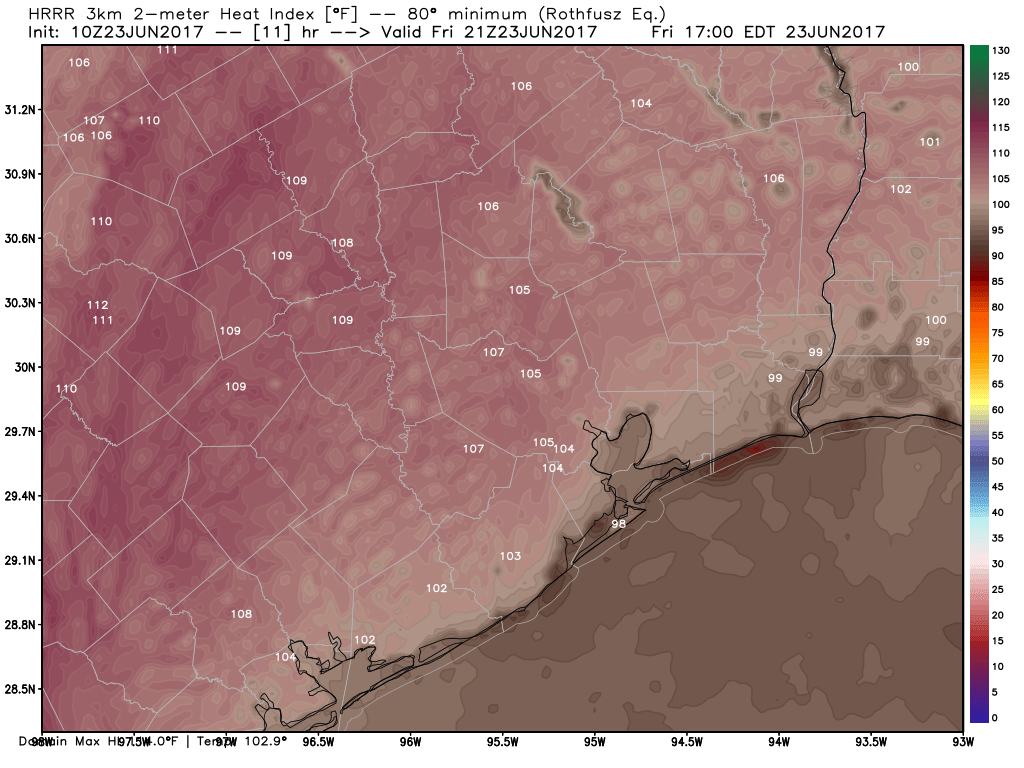
The National Weather Service has heat advisories posted today for Wharton, Colorado, Austin, Grimes, and Brazos Counties, as well as the cities of Austin, Dallas, Waco, and San Antonio.
In terms of rainfall, today should carry the lowest risk of the next several. If I were placing odds, I’d give it about a 10% chance of a rogue downpour, mainly this morning and mainly southeast of the city.

Weekend
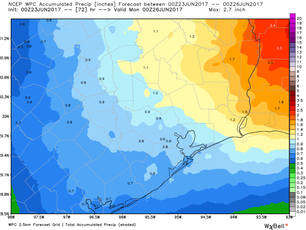
The most basic advice we can give you this weekend is to carry an umbrella. It will be very difficult to pin down exactly where and when downpours or thunderstorms will develop more than a few hours in advance this weekend, but we know there will be a good amount of them around. Odds favor you having to dodge raindrops at some point during the weekend but not the entire time. If you have to choose between Saturday and Sunday for an outdoor event, I’d probably lean toward Saturday at this point, but it’s a close call.
As Eric pointed out yesterday, we shouldn’t see anything too crazy here. No serious flooding or anything like that is expected, but locally heavy rain is going to be possible which could lead to some localized inconveniences for a short time. Just be prepared to find an indoor spot for a time if you’re planning to be outdoors this weekend.
Temperatures will be held back a few degrees this weekend with cloud cover. I’d expect upper 80s to near 90° Saturday and mid to upper 80s on Sunday.
Next Week
Showers and storms will continue to pester us each day for much of next week, perhaps easing back a bit as we go deeper into the week. They’ll likely follow a typical Texas coast pattern of being most likely south and east of Houston overnight and in the morning, then spreading inland during each afternoon. We will start the week in the mid to upper 80s and likely finish it around 90 or in the low 90s for highs. Overall, while unsettled, it looks pretty typical for June in Southeast Texas, all things considered. In addition, the tropics look to stay quiet in the Atlantic through the next seven to ten days.
Posted at 7:05 AM Friday by Matt
Thanks for the timely, measured and accurate updates during Cindy. Good job, guys.
UGH!!! Summer is the best reason to move out of Houston!