After a hot midweek, storms potentially return by Friday

Good morning. Let’s take a look at our forecast for the rest of this week and Memorial Day Weekend.

TODAY and WEDNESDAY

For the last couple of days sinking air and a weak capping inversion have won out over moisture, which has had the effect of limiting any showers and storms to only very isolated coverage. That pattern appears most likely to hold today and Wednesday, with any rain that develops doing so on an isolated basis. This means we’re going to see partly sunny skies and warm days, with highs in the mid- to upper-80s, and possibly 90 degrees by Wednesday. Since we still haven’t hit 90° this month I’d like to see that streak continue, but we’ve got to get through Wednesday first.

THURSDAY

We’re going to see a slightly better chance of showers and thunderstorms on Thursday, particularly during the afternoon hours. This will probably keep temperatures in the mid-80s.

FRIDAY

An upper-level storm system will move into Texas on Thursday and Friday, likely bringing 2 to 4 inches of rain for much of the northern part of the state and along the I-35 corridor. The question is how far this extends downward into the Houston metro region. I think we’re going to see some interaction between this system and the Gulf of Mexico moisture, but how much rain will that bring? Hard to say. Maybe only a few tenths of an inch of rain, maybe a few inches.

NOAA rain accumulation forecast for now through the holiday weekend. (Weather Bell)


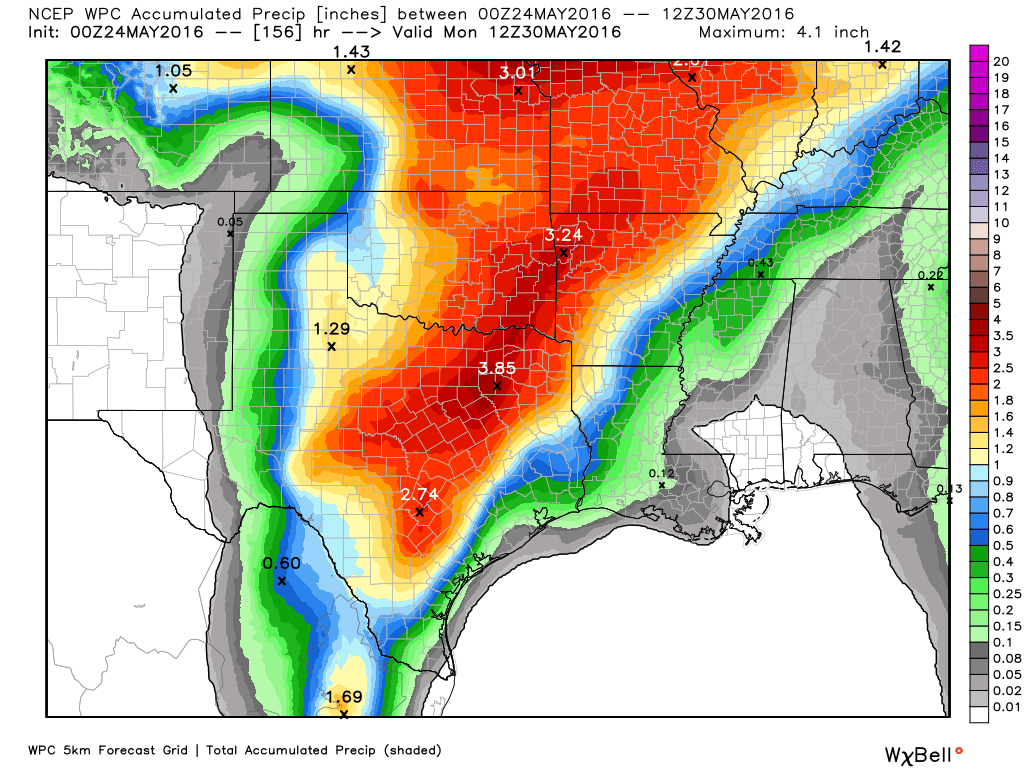
Any storms that do get going will have to be watched, because a sheared atmosphere will allow for the possibility of severe weather. At this point what we can say is that Friday and Friday night might be messy around Houston—stay tuned.

THE WEEKEND

By this weekend we’ll be back to pattern whereby we’ll see warm days in the upper 80s, with partly to mostly sunny days. In turn this daytime heating may drive the development of scattered afternoon thunderstorms. This, of course, is a very summer-like pattern.

Storms have brought Houston a cool May so far

After heavy rains Saturday, and almost nothing Sunday, what can be expected for today? Let’s discuss that in a moment, but first lets look at our cooler-than-normal May.

Every year we generally get warm, dry Mays or, if the storm pattern is more active, cooler and wetter Mays. This month has obviously been the latter. So far this May has been nearly 3° cooler than normal. Moreover, consider these high temperatures over the last eight days: 80,73,83,81,70,80,82 and 85 degrees. Normally at this time of year we should be edging into summer.

A graphical representation shows warm/dry May vs. wetter/cooler May dichotomy nicely:

Average temperature in Houston from May 1 through May 22. (Brian Brettschneider)

See full post

Without high pressure, expect Houston’s stormy pattern to continue

On Saturday we all found out the high pressure ridging that was supposed to shield our area of from widespread showers and thunderstorms this weekend did not, in fact, extend all that far into eastern Texas. Today there is no such mystery. The high pressure and drier air is far to the north of our region.

This water vapor image shows reddish, drier air well to the north of Houston. We're on the wet side. (NOAA)
This water vapor image shows reddish, drier air well to the north of Houston. We’re on the wet side. (NOAA)

See full post

Surprise! Quick storms this morning augur a more active pattern

Good morning. And for those of us who live in the Clear Lake area, it was an early morning as thunder rumbled through at about 5am. I will confess that I did not expect this. So what’s going on, and what does it mean for the forecast?

There are a couple of things at play here. First of all, the high pressure ridging that was supposed to keep us drier for most of the weekend and to start next week isn’t quite as pronounced, nor does it extend as far south into Texas as previously thought. We can see the effect of this by looking at a NAM model forecast of precipitable water for Texas at 5am CT Saturday morning.

NAM model forecast for (Weather Bell)
NAM model forecast of precipitable water for Saturday morning at 5am CT. (Weather Bell)

See full post