Textbook August weather ahead for Houston

As is often the case in August, in Houston, we’re going to remain more or less under the influence of high pressure for the next several days. Who knows, maybe for most of the rest of the month.

If there’s anything positive to be taken away from this it’s that this dome of high pressure isn’t so dominant as to eliminate all possibility of rain, nor push temperatures above 100 degrees, and afternoon heat levels to dangerous levels. We’ve been able to remain just cool enough that the National Weather Service hasn’t had to issue heat advisories for the Houston metro area. At least not yet.

But these are small comforts, and it’s still August. Therefore rain is going to be hard to come by during the next week, even though some moisture will return to the area on Friday. Here’s a look at the NOAA rainfall accumulation forecast for now through next Wednesday evening.

NOAA rainfall accumulation forecast for now through Wednesday evening. (Weather Bell)


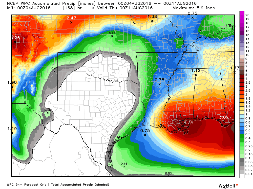
What you’ll notice about the forecast map above is that for most of Texas the only real rain chances are along the coast, and that’s probably the pattern we’re going to see, more or less, over the next week. Warm nights with lows only in the upper 70s, hot days with highs in the upper 90s, and sea breeze-driven showers during the warmest, afternoon hours, mostly along the coast.

This is pretty much textbook weather for August—a month to be survived on the way to more temperate fall weather in late September and beyond.

Posted Thursday at 6:30am CT by Eric

Heat continues for Houston—as one would expect in August

The heat rolls on for Houston, and after a 99-degree day on Tuesday we can probably expect more of the same for most of the rest of this week. We should see some better rain chances by the weekend however.

Today and Thursday

With high pressure anchored over Texas we’ll see some more scorchers, with some inland areas likely reaching 100 degrees. After some isolated showers on Tuesday morning we can probably expect the same today and Thursday. Most won’t see rain, however.

Friday through Sunday

As the high pressure backs off a bit, and moisture levels increase, I think we’ll see some better rain chances beginning later on Thursday or Friday. It looks as through the best possibilities for rain will come on Friday. Depending on how widespread the rain is, it could hold temperatures down into the mid-90s some days. However let’s be honest, it’s still going to be hot as hades out there, with precious little respite from the heat. Showers will likely be scattered at best most days.

See full post

If our days are getting shorter, why is it so damn hot out?

August is almost always Houston’s hottest month. It has a normal high temperature of 94.5 degrees, compared to 93.7 degrees for July, and 91.4 degrees for June. And typically, the region experiences its warmest day of the year this week, or next, according to data from the National Weather Service.

The week when different parts of the United States typically experience their warmest day of the year. (NOAA)
When different parts of the United States typically experience their warmest day of the year. (NOAA)


Looking across the country there’s an incredible spread of “warmest” dates, from early June (Southwestern United States) all the way to the end of September (West coast). But for most of Texas they come during the month of August. What’s interesting is that this is when our days are starting to get shorter.

Houston had its longest day in 2016 back on June 20, the summer solstice. The official sunrise was 6:21am that day, and sunset occurred at 8:25pm, making for nearly a 14 hour, 4 minute day. Next week, when Houston normally receives its “warmest day” of the year, there will be about 1 hour of sunlight less. (For example, on August 15, sunrise is at 6:50am, and sunset at 8:02pm).

A comparison between June 20 (top) and August 15 day lengths. (timeanddate.com)

See full post

The heat is on for Houston—maybe a bit of relief by Friday

Good morning. The heat is on this week with Monday’s temperature rising to 98 degrees, and more of the same on the way. We might finally begin to see a bit of relief this weekend.

Today through Thursday

We’re going to be pretty much under the influence of high pressure this week, which will make our days very hot—likely in the upper 90s—with mostly sunny skies and high humidity. While I’m not going to entirely rule out a stray shower or thunderstorm during the afternoon hours, they’re unlikely where you live.

The upside of this weather, for Texas’ sake, is that the near-tropical storm strength Invest 97L, presently sought of Jamaica, is very likely to remain on a westerly track around the high.

Model guidance for Invest 97L continues to keep the storm well south of Texas. (Weather Bell)

See full post