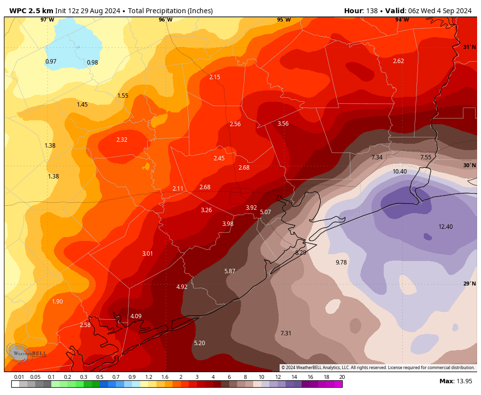
In brief: Today is the first of several days, likely lasting through the Labor Day weekend, that the Houston area will be subject to the potential for widespread showers and thunderstorms. For most of our region these will be a nuisance, but for the immediate coast there is the potential for street flooding, which is why we’re initiating a Stage 1 flood alert for coastal counties.
Stage 1 flood alert
We are putting this flood alert, based upon our flood scale, in place due to the potential for heavy rains near the coast during the next several days. A Stage 1 alert simply highlights the potential for intermittent street flooding, particularly in low-lying areas, and possibly along some feeder roads. I anticipate keeping this alert active through Labor Day Weekend.

It applies to coastal counties across our region: Matagorda, Brazoria, Galveston, Chambers, Jefferson, and Orange. Essentially, that’s the entire upper Texas coast. The reason is that these areas will be closest to the source of moisture, and susceptible to the most frequent rainfall. Some of our latest modeling indicates the heaviest rains will be further east, in the Beaumont-Port Arthur area, but I feel the entire upper Texas coast is at risk. These coastal areas could see 5 to 10 inches of rain over the next week, with higher isolated totals.
Thursday and Friday
After rainfall of a more scattered nature for the last couple of days, showers and thunderstorms should become more widespread beginning today. As noted above, rain chances will greatest right along the coast, but all locations along and south of Interstate 10 will be prone to periods of medium- to heavy rainfall, with lesser chances further inland. Rains today and Friday will be driven by a combination of lots of moisture in the atmosphere along with an upper-level low pressure system that will help drive the formation of storms.
Based upon high-resolution modeling, which is not great but the best we have, I anticipate showers and thunderstorms to start developing over coastal areas around 8 to 10 am this morning and then persist, on and off, for much of the daytime. Activity may diminish somewhat this evening before redeveloping on Friday. With plenty of cloud cover, high temperatures today should remain in the upper 80s for most locations, although some inland areas with scattered sunshine may reach the lower 90s.
Labor Day Weekend
Widespread showers and thunderstorms, particularly for coastal areas, will likely persist from Saturday through Monday as the atmosphere remains ripe for showers. Houston, particularly inland areas, will not see wall-to-wall rain this weekend, but there definitely will be the potential for storms to pop up and mar outdoor activities. Intermittent showers and clouds should help keep highs to the upper 80s to about 90 degrees for most locations this weekend, so this will definitely be one of the cooler Labor Day Weekends we have had of late.
Next week
Rain chances will persist on Tuesday and Wednesday before slackening some toward the second half of next week. This probably will allow high temperatures to claw their way back into the lower 90s. I don’t want to jinx anything, but there is a non-zero chance of a weak cool front pushing through in the September 8 to 10 period. Right now I would give it about a 25 percent chance, based on the medium-range modeling. Even if it doesn’t happen, the mere fact that we’re looking at the possibility of fronts suggests that fall may not be all that far off.
Tropics
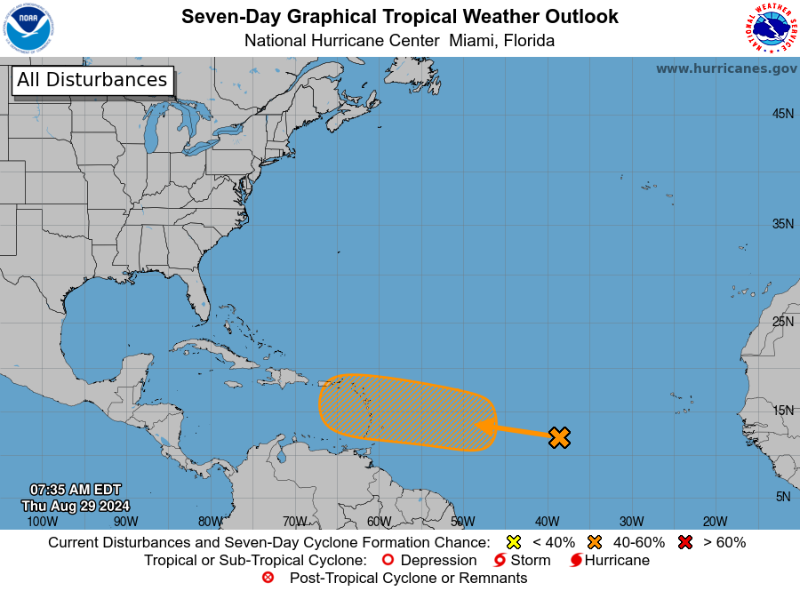
As August comes to an end, the lull we’ve been enjoying for awhile now is likely to come to an end as well. There is increasing model support for the development of a tropical system in the Central Atlantic which will then move toward the Caribbean Sea. After that? There’s not agreement in the models, so pretty much anything could happen. But given that we’ll be in early September at that point, it’s definitely worth keeping an eye on the tropics.

I can’t handle another hurricane, guys.
Yeah, that’s how I’m reading it too
It was expected activity would pick heading into September
That doesn’t make it any easier
True, but you can’t be surprised when there’s a possibility of a hurricane this time of year, which is why every year people are told have a hurricane preparedness kit and plan in case your affected
If we are talking cold fronts already, doesn’t that usually mean persistent high pressure is going to start building over central North America and that will help to block the hurricanes from getting to Texas? Similarly, once a couple of fronts come through here they will also help push the hurricanes east of here?
That is true but not always the case. Sometimes hurricanes can actually build off stalled cool fronts in the gulf and then shift northward into Texas. This happened with Hurricane Nicholas in September 2021 and the cat 2 Freeport Hurricane in October 1949.
It’s not Labor Day in Houston unless there is a potential hurricane sword hanging over our heads
Labor Day is not a holiday I look forward to in Houston.
Or flooding lol
In your opinion do you personally think thr system will head toward the Texas coast?
Yesterday Space City Weather said the system didn’t seem to give them very much concern about impacts for us.
That seems to be a pattern with them.
I’m sure with new information comes new forecasts, but I’m curious has to what has happened in the last 12 hours that is a source of concern.
I don’t think there’s a SCW conspiracy to mislead us about the weather. It’s very difficult to predict the weather. Conditions can and will change. I keep trying to time the stock market and I keep hoping there’s a web page I can complain to when my stock goes down.
I know there’s not a weather conspiracy… but if SCW actually is part of “Big Weather”, I want in.
I think people are misunderstanding what “concern” means. For me, it’s something to pay attention to but not to get wrapped up into it, freaking out about a miniscule chance of being affected. I’m not concerned yet, it’s too early. If I got scared of every tropical wave, I’d be bald from stress.
My lawn is parched. I keep waiting for some rain to fall to avoid getting the sprinkler out, which hasn’t been used all summer. I was in a deluge driving to work a couple of days ago, but so far, only .05″ at my house over the past few days.
Yeah these scattered downpours during the summer can be so frustrating because the same areas tend to get repeated downpours while areas just a few miles away continue to get nothing but sprinkles and thunder. You have to be right under the storms when they develop or else your yard isn’t going to get nothing but the light rain leftovers.
Just as we were discussing yesterday. I don’t know where you guys live, but here in Santa Fe, we always seem to miss the rain. It seems as though Dickinson, which is north of us, gets rain just about every day, while we sit here in the sun and bake. However, this hasn’t been happening just recently. I’ve lived here in SF for 40 years and this has been going on ever since I had our home built out here. There’s got to be a scientific reason and I’d certainly like to find out the answer.
The question is, will Centerpoint be ready for another Hurricane???
I think that’s the one inquiry about this we have an actual answer for…..and it’s a resounding ‘no’.
They’ve certainly been crowning all the trees in my neighborhood. Why they were planted under the lines in the first place, I’m not sure.