In brief: An unexpectedly intense flooding event has engulfed areas north of Houston this week. We discuss that, and the ongoing forecast for the weekend, which could see an additional round of storms on Sunday before things start to dry out next week.
If you live south of Interstate 10, you may be wondering what the fuss is all about in regards to heavy rains this week. Much of this area has received 2 inches or less over the last five days, and certainly not experienced anything remotely close to flooding conditions. However, looking at the rainfall accumulation map below, we can see that eastern Montgomery County got rocked with 12 inches of rain, and further to the north, Walker and San Jacinto counties recorded 15 to 20 inches of rainfall. Some of this came very quickly, with high rainfall rates.
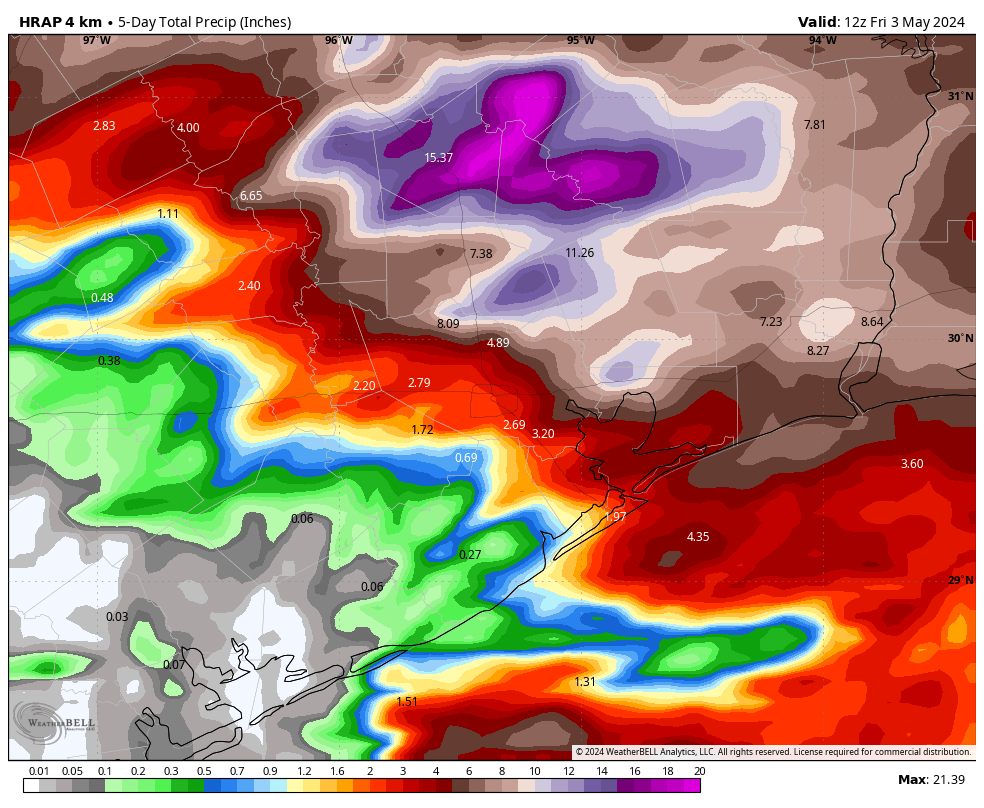
And so we have a situation where much of the region is just fine, but there is terrible flooding ongoing along the San Jacinto and Trinity river basins. The most dangerous flooding is occurring along the East Fork of the Jacinto River, but the entire north and northeastern parts of the Houston metro area are dealing with significant and ongoing flooding.
What’s next
So what happens next? After today’s showers, we should see a reprieve for the rest of this afternoon and evening. Our record for predictions this week has been pretty shoddy, but at this point I only expect development of sporadic showers on Saturday morning. And most of Saturday, frankly, looks mostly rain free. At this time I think we’re unlikely to see more than scattered showers and thunderstorms, with accumulations not amounting to much.
Unfortunately, it does appear as though a final storm system will work its way toward the area later on Saturday night, or Sunday morning. This atmospheric disturbance will likely bring widespread showers and thunderstorms on Sunday morning-ish, and perhaps throughout much of the day. As a rough guess we’re looking at additional accumulations of 1 to 3 inches, with the potential for higher totals. This will, unfortunately, only exacerbate ongoing river flooding.
By Sunday night high pressure really should begin to assert itself, and most of next week looks sunnier, and hotter. Rain chances look lower for most of the week, although perhaps not zero.
Given the unpredictability of the storms we’ve seen this week, and the threat of additional rain on Sunday, we’re going to continue with posts each morning this weekend to keep you updated. Thanks as always for reading, and for your patience as we have struggled to grapple with a challenging forecast that has been more miss than hit.

Thank you for all the information! I do have a question. I have a daughter who will be traveling to W. Monroe, LA.
today – what are the weather conditions from Houston to W. Monroe via I-10 the Hwy 165 ? If you can please give me a general update and any danger zones. She is leaving at 6:00 PM Thank you so much
Check Dopplar Radar – looks clear.
https://weather.com/weather/radar/interactive/l/d5e4bbff9976eda22aabc9790b56949eb1764bc3deb919998914ee575a73b1aa
Thanks for all y’all do to keep us informed and safe!! God Bless.
Thank y’all for being honest & no BS hype😎
Thank you for all you do.
We trust no other weather forecaster than Space City weather. I So appreciate the straight forward forecasts…..
12.5 in Spring, Texas
I know the rainfall map is an estimate, but in southeast Katy we have received 4.8”, which is considerably more than the map shows.
Low for Clear Lake too.
I appreciate your extra efforts over the last few days! We don’t have dedicated broadcast media here in south Montgomery County, and the Houston TV forecasters don’t always provide a lot of detail for areas so far from the city limits. So thank you, Space City Weather, for the ongoing weather info and forecasts. Much appreciated!
I’m impressed by you’re forthrightness. KHOU on Sunday thought Thursday would be relatively dry but did not comment afterwards. Thanks.
Question for Sunday, is the rain going to be localized (like just League City or Conroe) or more widespread over the entire city. Also, will it be done by late afternoon? Have a large group destroying a piñata on Sunday and although we have cover, I don’t think the tropical like weather we have been having recently is conducive to piñata destruction.
Really appreciate you 🌬 ⚘
Clear Lake/Northfork received 5″ (4″ + 1″) over the aforementioned period. Happy lawns…
No need to apologize. It’s not your fault, it’s the weather. You do a remarkable job with the cards you are delt.
Keep up the good work!
“If you live south of Interstate 10, you may be wondering what the fuss is all about in regards to heavy rains this week.”
Indeed, it seems like these last three or four big storm systems have largely been unable to penetrate beyond I-10. Why has that been the case of late?
Very great full for you guys and gals for looking after us all! Hit or miss. Thank you.
I’m always shocked by the people who think Eric and Matt are their personal forecasters. Sometimes they even oblige, but is presumptuous to put your personal weather questions on this blog, read by thousands, and expect your own personalized forecast in response.
Galleria area, we received 4 inches of rain in two days. no street flooding, but a bunch of rain. Glad I wasn’t in East Texas
For Sunday will the Galleria get 8” in four hours, like the Memorial Day Flood?
Those look a lot like 2016 Tax Day flood numbers. Were the atmospheric conditions similar?
Gentlemen:
Thank you for your outstanding efforts and analysis. There is none better.
Kindest regards,
Daniel B. Weber