In brief: Flash flood warnings are in effect for Montgomery, far northern Harris, and Liberty Counties this morning, as an additional 1 to 4 inches of rain has fallen. River flooding will continue in those areas as well, with numerous evacuation orders and road closures in effect. Major rain should hopefully exit this morning with more intermittent, scattered downpours through the day. Additional storm chances exist tonight and especially Sunday before the heat sets in next week.
A flash flood warning is in effect north of Houston through 8 AM, as another batch of heavy rain fired up overnight dropping 1 to 4 inches of rain between southern Montgomery, northeast Harris, and northern Liberty Counties.
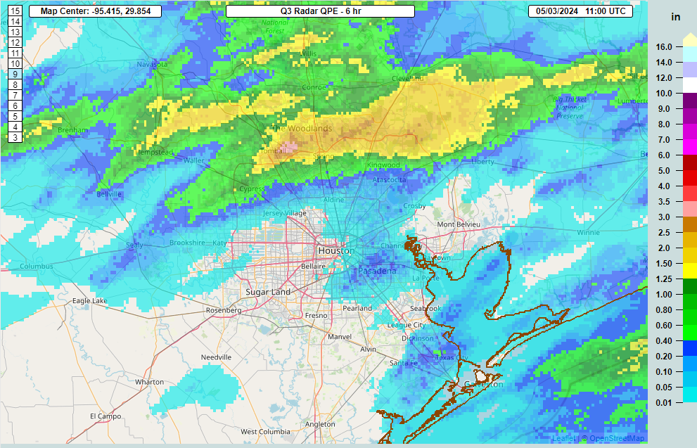
This is not where we wanted to see the rain this morning. We do expect that this will actually move along at a better clip than yesterday’s rain did. Hopefully that leads to some quicker improvement, but all this water will help further swell the river systems up there. You can view flood gauge information on rivers, creeks, and bayous at the National Weather Service or at Harris County Flood Control. Please follow the advice of your local officials, and never drive around barricades.
A Flood Watch remains in effect along and north of I-10, extended through Saturday, and we will maintain our Stage 1 flood alert for Houston.
The San Jacinto and Trinity Rivers remain the two most serious issues at this time. There will continue to be rises and damaging flooding within both systems. Additionally, the Navasota River is expected to crest at record levels north of Bryan. That feeds the Brazos, and we’re likely to see high water or minor flooding begin in that river too as we head into next week. Thankfully, we aren’t expecting a whole lot worse in that system. A lot happening, and we’ll keep you posted on any significant changes with at least one more update later today.
Today
The rest of this morning is expected to see this very heavy stuff north of Houston exit east and be replaced by more in the way of scattered thunderstorms.
If we can pop more in the way of scattered storms, yes, that will lead to isolated heavy downpours, but more often than not it wouldn’t rain over one place hard for more than 15-20 minutes at a time. Even a few rounds of that is more manageable than the deluge and 2 to 6 inch per hour rates we’ve seen this week. We’ll continue watching and keep you posted. Have an umbrella and an indoor backup plan anywhere in the area today just in case. Highs will range from the upper-70s in places it rains persistently to low-80s. Showers should diminish in coverage this evening.
Saturday
Do we expect more showers and storms to fire up overnight tonight and Saturday morning? It’s NBA playoff season, so in the words of Marv Albert, “Yes!” Unfortunately we will probably see additional rains in saturated and flood-impacted areas north of Houston. There is a chance that this ends up being a little less rain than today, so hopefully that’s the case. Otherwise, sun, clouds, and 80s.
Sunday
The back half of the weekend looks to remain unsettled. Another wave of storms could pass through the area in the morning or afternoon hours, especially north of I-10, again. Rainfall could again be heavy, and right now I am a little more concerned about Sunday than Saturday in terms of rain and impacts. Outside of any storms, expect clouds, some sun, and highs in the 80s.
Next week
I wouldn’t be shocked to see one more round of showers or storms on Monday or Tuesday, but then the heat cranks up. Expect upper 80s on Monday, low-90s by Tuesday, and low to mid-90s on Wednesday and Thursday.

It will feel uncomfortably hot, given this is first real heat of the summer season, so take it easy. Morning lows will generally be in the mid-70s. We may see rain chances return toward the weekend but for now that’s mostly speculation, and I wouldn’t be changing any Mother’s Day plans at this time.

Thank you for the concise, to the point, coverage of this event – unlike the TV stations which are droning on and on showing the same pictures of the same flooding over and over again. Including the worthless footage of flooding in the dark. Tuning out. There are better ways to communicate.
This is the way media covers these type of events. Its been like this for a long time, show the event in progress, the aftermath, interview victims, then the recovery
Is there a meteorological reason why these storm keep concentrating on the same areas? As a Kingwood resident I would rather see the love shared with everyone so that everyone gets a little rain and nobody floods?
I’d hope to share this rain love with the good people of Lubbock and Midland. Or, even better, dump it into the upper Colorado River to help them increase their reservoirs and river flow.
Crazy the difference, I have received.42 inches this week in sugar land.
And a little over 4″ in Clear Lake.
About 5″ total in Northfork (near NPE school; 4″ + 1″).
Meyerland area: 0.76 inches Thursday and 0.08 inches so far today (11:22 am on Friday)
Santa Fe area: 0.55 inches Thursday and 0.40 inches so far today (3:30 am early Friday morn.)
How are the airports looking today? I’m flying into IAH this evening and am concerned about flight cancellations/delays.
I really don’t know how much we have received here in Kingwood by 69. The rain gauges on the ground by the deep street ditch were overtopped. I surmise we were over 6” yesterday. More heavy rain now with much thunder and lightning. This area is expecting major flooding of homes and businesses due to river floods. Lots of traumatized people now since they experienced Harvey, Imelda and more flooding.
Yesterday, I got 5.1″ between 8 am and 9:30 am at my Kingwood home, then another 2.4″ between 9:30 am and noon.
I am in sugar land and have an outdoor dinner planned for my birthday this evening… at what point can we expect the rain/storms to start tapering off? Getting really nervous about it…
You are in Sugar Land so you’re fine. If north of I 10 then just don’t plan anything outdoor ever.
This is an insane question. People flooding and you live in an area of town that has barely seen anything–and is not forecast to receive much of anything–and you’re worried about a birthday dinner? Are you 11 years old?
Well I mean, Noura doesn’t want to get her bounce house wet or the clown to be soaked during his performance so it’s understandable. /s
Happy birthday Noura! Don’t let rain clouds like Robert get you down!
Y’all are really good at weather!
after yesterday, i find myself unable to trust the radar… it was literally 15 minutes between ‘it’s gonna be fine to drive downtown’ to ‘aw, heck no’. I see that y’all are also a bit stunned by it.
While quite dark here, it looks like it will all stay to the east. But will it really?
(and yes, y’all are really good at weather!)
Too much of a good thing can definitely do some harm. But, will these floods help our reservoirs and soils and prevent a drought for our area this summer?
All, I need to apologize. After 2 years in a row of all my plants dying due to drought and heat, I planted a bunch of drought tolerant plants like Texas sage about 2 weeks ago. Now they’re probably going to die from drowning. My bad y’all.
I’ll take some of the blame. I washed my car two days ago.
Try Harris County natives for the best luck. Houston Audubon and Buchanan’s are good sources.
Using the current mayhem to try to understand the weather patterns here a little better….
Noticed that a low is draped across the plateau last few days. Maybe as Jos has pointed out previously, that takes the warm aloft area out of the picture temporarily and we get a lot more rain.
Why are these storms always north or east of Houston since we are closer to Gulf?
The storms this week aren’t coming from the Gulf. They originated over land and are mostly moving across Texas and into Louisiana from west to east or northwest to southeast.
Does any data suggest Metro Houston would get the same amount of rain the flooded northern counties have gotten, during the next few days while this pattern stays in the area?
why are yall complaining? rain is a very good thing. Its nice and cool. Yes summer is coming. Its May already.
Because people are being flooded out of their homes? What a stupid question.
I mean, yes. Typically. But people have feet of water in their homes and there have been many high water rescues over the past few days. Too much of a good thing, and all that
🤡 comment as people are getting their properties and homes destroyed by flood.
We had roof damage from early morning Thu storms, moved everything around. Watching water stains soak through the gypsum. Quite the party.
Now, with early morning Fri storms, we’ve got new ceiling staining friends wanting in on the action. One of the leaks was considerate enough to be right over the bathtub.
Moving things around again, very concerned about Sunday morning. It’s feeling like a house of cards.
Wishing everyone N of us as well as they can be.
Rains haven’t really pushed out to the east, keep back building over the northern areas. Models are out to lunch. Hell, we might get blown away with a massive round of storms tonight into the morning. All the way to the coast for the final show.
picnic date on sunday looking more and more unlikely 🙁