In brief: The main story over the next week will be heat, with high to periodically extreme conditions for the Houston area. Shower and storm chances will diminish but probably never get to zero. Saharan dust should show up this weekend before declining. And the tropics are busy with stuff to watch but no serious concerns for us at this moment.
Today through Sunday
As high pressure begins to expand over Texas, somewhat reminiscent of what happened last summer, the spigot should temporarily shut off here in Houston. We can’t rule out an isolated shower in the area, but the coverage of rain is going to diminish. The main story through the weekend will be heat. Heat advisories are in effect today and will likely be in effect tomorrow as well. Highs will be well into the 90s to near 100 in spots. Morning lows will be around 80 degrees.
Sunday will be interesting as a plume of Saharan dust arrives in Texas. We’ll see hazy skies which won’t help a ton with the temperature, but it may lead to a slight decrease in how bad it feels outside. Here’s the wet bulb globe temperature (WBGT) outlook for the next week, and you can see the slight dip on Sunday from “extreme” levels to “high” levels.
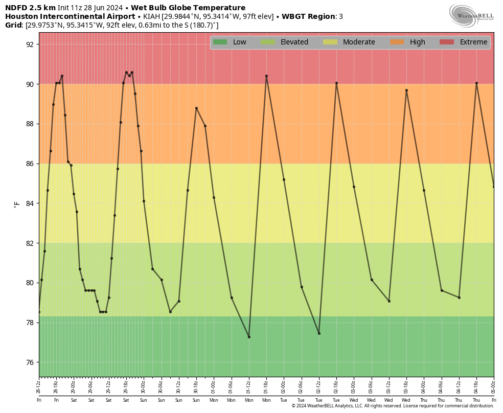
Remember, WBGT is a good, objective measure of how intense the combination of heat, humidity, wind, sun, and more is on the human body. Extreme levels, which we frequently hit last summer indicate heat where everyone should take precautions, even hardy Houstonians. High levels are more typical in Houston throughout summer. So, just take it easy this weekend.
Next week
The forecast is somewhat on autopilot for most of next week. High pressure should stay in tact, centered to our north or northeast most of the week, keeping us plenty hot, but never sending rain chances to zero. They will be quite low on several days though. Expect highs in the upper 90s to near 100 degrees with lows in the 70s to near 80 degrees; a very “high summer” feel for early July.
Fourth of July
At this point, it would seem that most plans should be good to go. We can’t rule out a shower, of course, but anything severely disruptive seems unlikely. Just make sure you’re hydrated (with water) and able to cool off. Evening festivities will probably see temperatures drop from the 90s into the upper-80s. Call it about a 10 percent chance of a shower or storm right now, but we encourage you to check back Monday for the latest.
Tropics
We continue to monitor Invest 95L, which is almost certainly going to become a depression or tropical storm by the end of the weekend. We have daily updates at The Eyewall, our companion site, and we will continue to provide those all weekend.
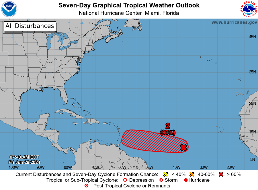
For now, we expect this to be a concern for the Lesser Antilles before it gets disrupted by land or the usual shenanigans present in the eastern Caribbean in early July. From there, all bets are off, but a general west or slightly north of west motion should continue toward Central America or the Yucatan. It is not a serious concern for us in Houston right now, but we’ll be watching it closely to see if anything changes.
The other system moving into the Bay of Campeche this weekend (Invest 94L) will move into Mexico with no impacts for us in Houston or Texas.


Welp, time to evacuate.
I’ve already fled
Let’s talk about notching our first 100F on Monday or Tuesday. As most of us know… there will be no windy rain from the tropics unless the dome releases its grip at the same time a storm is in the Gulf. Relentless upper level ridge is the new normal? Any thoughts
If 95L enters the Gulf as a storm, is Houston likely to have high pressure to protect it?
That’s too far in time for any accurate prediction on 95L destination for now
you guys have been making heat the topic of your main story all year long, why not focus more on rain and why it’s so scarce and why the models mess up so much on rain predictions
Maybe because they’re not telling a story, they’re giving a forecast? And rain has not been scarce for most of us the past couple of months.
Rain scarce? Is this a joke? FWS has my area (Spring) pegged at >20 inches of rain since May. We’re still sopping wet here and need some time to dry out. Bring on the high pressure.
I used to know Kuykendahls who went to St Francis whilst my boys were there, any connection?