Houston headed toward the low 80s this weekend

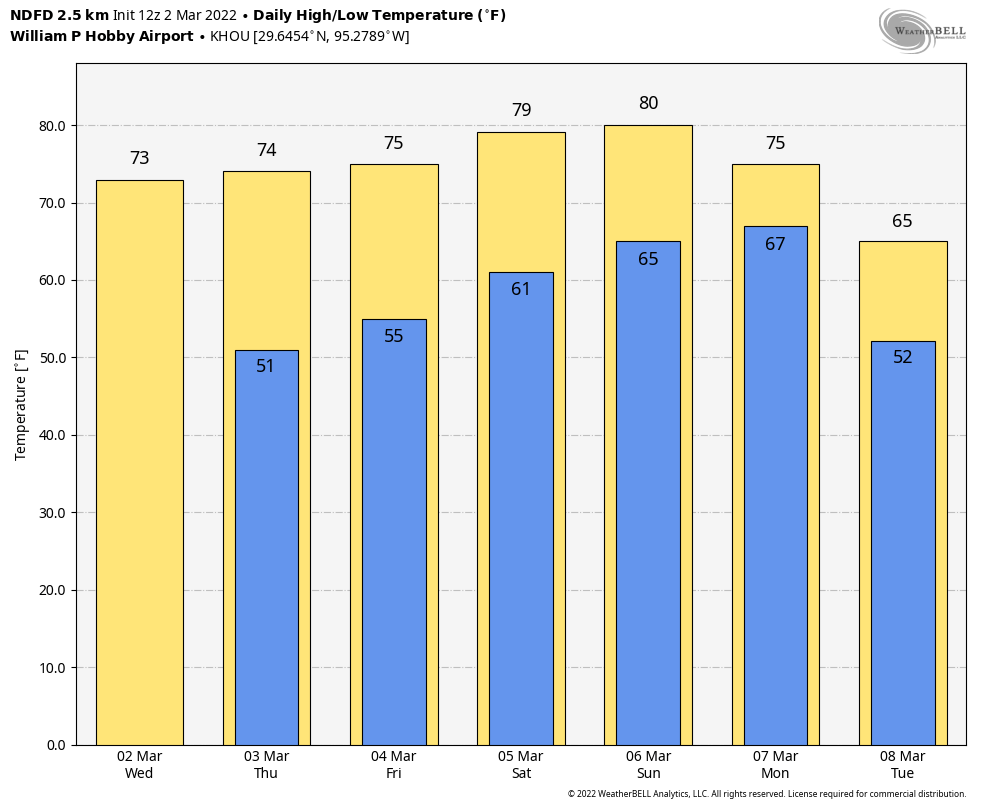
Humidity levels are starting to rise with a southerly flow across the region, and today will be the last day with moderately dry air before dewpoints rise into the 60s for the weekend. Temperatures will reach the low 80s by Sunday. Still, most outdoor activities should be fine for the next few days, with only fairly low chances for some light rain.

Parts of Texas are cold this morning, and parts of the state are not. (Weather Bell)

Thursday

Some parts of Houston are seeing a bit of fog this morning due to light winds and dewpoints matching temperatures, but this will burn off fairly quickly as the mercury rises this morning. The region is headed toward the mid- to upper-70s today, with partly sunny skies, and light winds from the southeast. As high pressure moves off our region will start to see a more pronounced onshore flow, and humidity levels will ramp up through Sunday. But today should still feel somewhat dry. Overnight lows will drop into the 50s for most locations.

Bound for the Houston Livestock Show and Rodeo to see for King & Country tonight? Temperatures this evening will be in the 60s, with light winds from the southeast and partly cloudy skies. Rain chances are nil. Temperatures after the show will be about 60 degrees.

Friday

As the onshore flow becomes more pronounced we’ll see winds pick up from the southeast, perhaps gusting up to about 20 mph. This will further boost atmospheric moisture levels, but I don’t think we’ll see any rain yet. Highs should reach the mid-70s beneath of mix of sunshine and clouds.
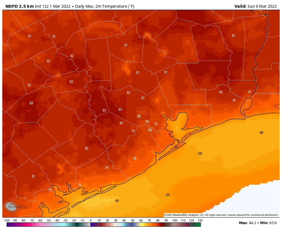
Saturday and Sunday

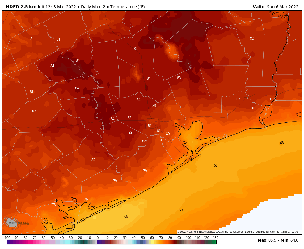
Both of the weekend days should feel similar, with highs around 80 degrees or a bit higher west of Houston, and dewpoints in the 60s making it feel reasonably humid outside. There will be some sunshine, some clouds, and perhaps a 20 percent chance of a brief rain shower each day. Lows will be in the mid-60s. This should be a fairly typical spring-time weekend for Houston.

High temperatures will be fairly warm on Sunday. (Weather Bell)

Next week

A cold front arrives sometime on Monday, probably around sunrise, to turn our weather cooler. This front should drive high temperatures down into the 60s, and nights into the 40s and 50s, for a few days. Since the atmosphere will remain disturbed after the front’s passage we probably will see mostly cloudy skies for a few days, with modest chances for some light rain showers through Wednesday or so.

Houston continues to slip into spring

Good morning. We’re continuing to warm up, with temperatures this morning generally 40 degrees or above for the metro area. We’re going all the way to the low 80s by this weekend before the next front arrives. If you’re looking for more signs that spring is coming, you can check the Houston Health Department’s daily pollen and mold count report. We’re starting to see heavy levels of tree pollen. For some of us, this means the beginning of a sneezy spring.

Houston pollen and mold count for Tuesday. (City of Houston)

Wednesday

High pressure remains in place, and that will bring us one more day of really dry air. Highs today will warm to about 70 degrees, or a little bit warmer, with light southeasterly winds. Skies will be mostly sunny, but a few clouds are possible tonight as low temperatures drop into the 50s across the region.

If you’re heading out to the Houston Livestock Show and Rodeo to see Tim McGraw later today, temperatures this evening should be in the low 60s, with light winds, and partly cloudy skies. After the show, temperatures will have dropped into the upper 50s, with perhaps a few more clouds. So there are no weather concerns at all!

Thursday

High temperatures will likely rise to the mid-70s on Thursday, with a little more humidity. Skies should still remain partly to mostly sunny, however. Lows Thursday night won’t fall much below the mid- to upper-50s.

Friday

This should be another partly to mostly sunny day, with highs in the mid-70s. As winds from the south become a little more pronounced at 10 to 15 mph, it will also start to feel more humid outside. Lows Friday night may not drop below 60 degrees.

Houston will see stairstep weather this week. (Weather Bell)

Saturday and Sunday

The forecast for the weekend is coming into better focus, and it looks to bring warm and partly sunny weather to the region. Look for highs both days to reach about 80 degrees, and perhaps a few degrees warmer for western parts of the Houston area. While some light, very scattered showers are possible each day, overall there doesn’t seem to be much atmospheric support for rain to develop. Overnight lows will be warm, in the mid-60s.

The next cold front should arrive some time on Monday, likely cooling our weather down into the 60s, with lows in the 50s. We probably won’t see as much sunshine after this front as the atmosphere remains disturbed and with showers are possible into mid-week.

March begins, and so does the march toward warmer temperatures

The mercury has dipped into the upper 30s at many locations this morning across Houston, and it is quite chilly. This will not be the last of the chilly weather this week, but it probably will be the last morning in the 30s for much of the metro area. In fact, this week may see the final mornings in the 30s this season. I’m not ready to guarantee this, but we are certainly moving from a winter-like pattern, with regular cold fronts, into spring. The next cold front will not arrive until at least next Monday, and it will be a modest one.

Temperatures just before sunrise were cold across Texas this morning. (Weather Bell)

Tuesday

With clear skies and light winds today will be another winner across the metro area, as high temperatures warm to about 70 degrees. There’s not much more to say, other than to enjoy the beautiful conditions. Low temperatures on Tuesday night will likely drop into the upper 40s, so a few degrees warmer than Monday night.

For those headed to the Houston Livestock Show and Rodeo this evening to see Keith Urban, or just eat a fried something or other, there are no weather concerns. Temperatures will be in the mid-50s this evening as the sun sets, with light winds. The mercury will drop to around 50 degrees by the time the show ends.

Wednesday and Thursday

These will be two more days with mostly sunny skies, highs in the low 70s, and generally light winds. By Thursday night low temperatures will only be falling into the 50s across the region, but there will still be enough dry air for nights to be pleasantly cool.

Friday

By the end of the week, under the influence of a southerly flow, we’ll start to see moisture levels rise in the atmosphere and this will lead to more clouds and humidity. Expect highs in the mid-70s on Friday, but lows Friday night to only drop into the 60s. Some very light, isolated rain showers are possible Friday night.

Expect high temperatures in the low 80s by Sunday. (Weather Bell)

Saturday, Sunday, and beyond

This weekend looks warm. Both days should see highs of around 80 degrees, with fairly humid air. But that’s where our certainty stops. Both Saturday and Sunday should see a mix of sunshine and clouds, but will clouds dominate? And will the atmosphere be perturbed enough to squeeze out a few scattered showers? For now I’m pretty pessimistic about any real rain chances this weekend, but I can’t rule them out. Nights will be warm in the 60s.

Next week should see continued warm weather before the next front probably works its way through on Monday or Monday night. This should drop temperatures 10 or 15 degrees, and bring a modicum of drier air.