Houston’s weather will calm down a bit, but rain chances will hang around for the weekend

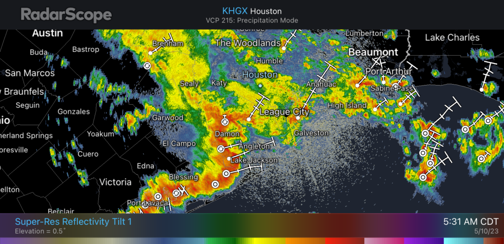
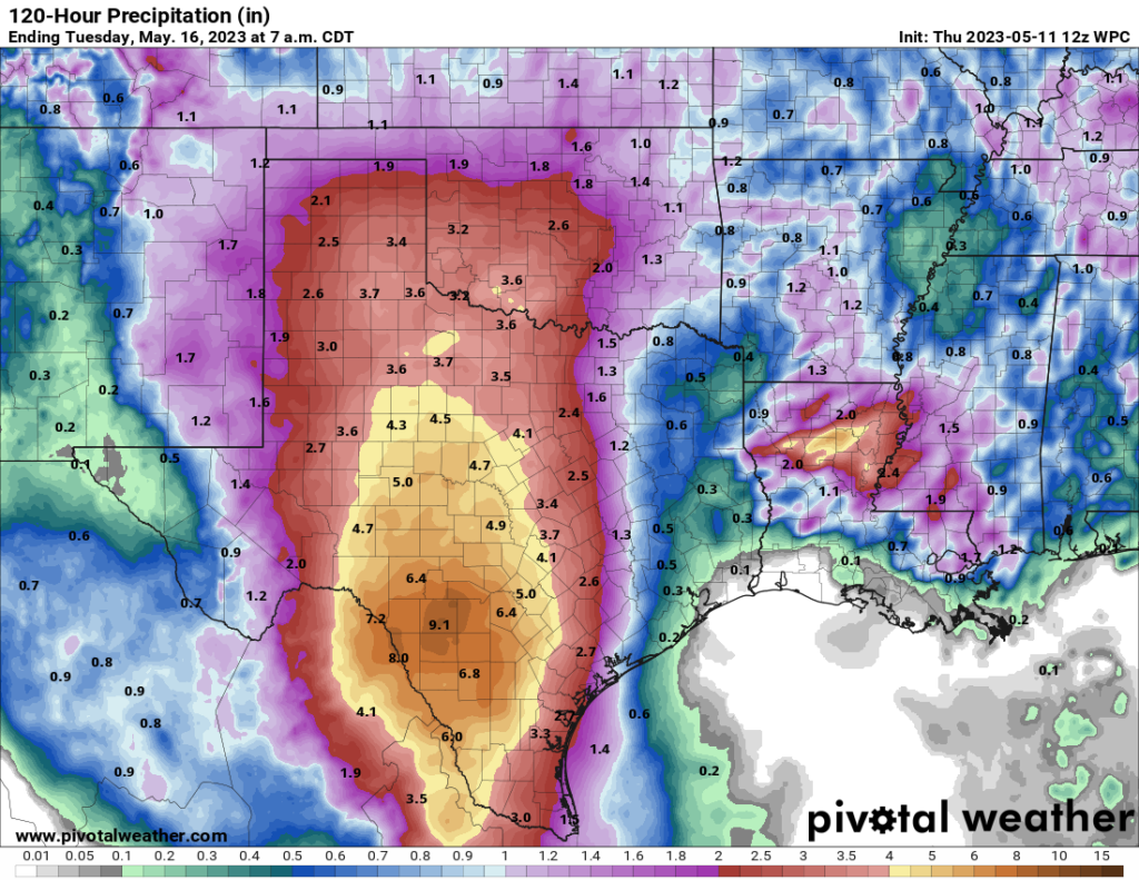
Phew—after two days of warily watching the radar, we can take a break. Rain chances today and Friday will fall back into the 10 or 20 percent range, and we may even briefly see some sunshine during the afternoons. However, as an upper-level low pressure system evolves over Central and West Texas this weekend, it will create conditions favorable for rain there.

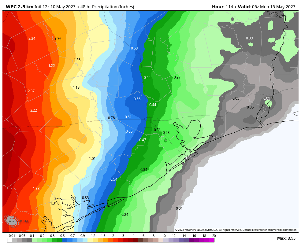
This means two things for our side of the state. First of all, areas west of Interstate 45 will see reasonably high rain chances in the range of 50 or 70 percent on both weekend days. And secondly, if your Mothers Day Weekend plans call for travel into the Hill Country, conditions look incredibly wet, with 4 to 8 inches of rainfall along the I-35 corridor and to the west of Austin and San Antonio. This is bound to lead to flooding and other issues this weekend there.
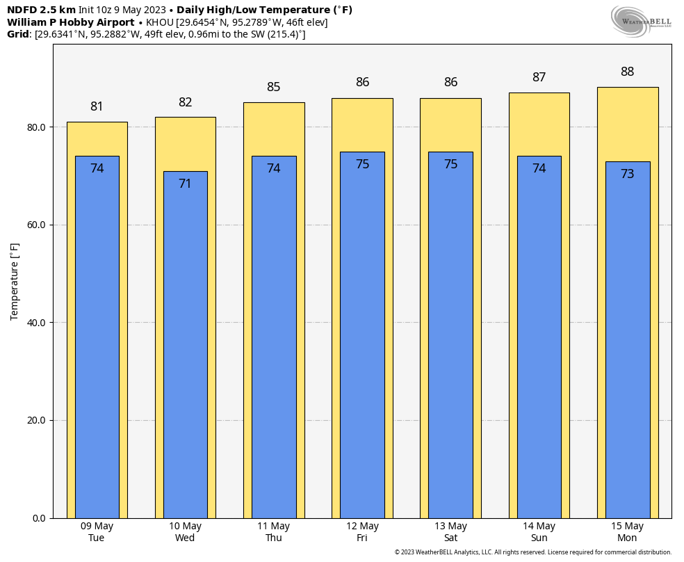
NOAA rainfall outlook for now through Monday night. (Weather Bell)

Thursday

Skies are cloudy this morning, but we should see some partial clearing this afternoon, and that should allow high temperatures to push up into the upper-80s. Winds will be light, out of the south. And the rain? Well, chances are about 10 percent that we see some very light showers. The air will be sticky, and lows tonight will only drop into the mid- to upper-70s. So yeah, pretty muggy.

Friday

Friday will be rather similar to Thursday, albeit with slightly stronger southerly winds, gusting up to perhaps 20 mph. Friday night will be warm again, as temperatures may drop into the mid-70s.

Saturday and Sunday

Both days will see highs in the mid-80s. Saturday is probably mostly cloudy, but Sunday may live up to its name with a little more sunshine. The question, as usual, is rainfall chances. Both days have about a 50 percent chance, and the further west of Houston you live, the greater overall chances there will be. Much of Houston probably will see less than one-half inch across both days, but areas such as Katy or College Station are at risk for 1 inch or more.

The temperature for the week ahead is mostly moderate for May. (Weather Bell)

Next week

Monday should be a touch warmer, in the upper 80s, before a front arrives Monday night. You should set your expectations accordingly, and by that I mean that this front is going to bring some (very slightly) drier air to the region, but won’t modify temperatures too much. Highs for most of next week look to be in the mid- to upper-80s, with partly sunny skies, and lows in the low 70s. Rain chances remain, but overall they don’t look too high, or bring too much of the wet stuff to us.

Heavy rain will fall throughout much of Houston on Wednesday morning, street flooding possible

A slowly-moving low pressure system is bringing a band of heavy rainfall into the Houston region this morning. As of 5:30 am CT the main line of storms remains southwest of the city, from Sealy to Needville to Lake Jackson. The heaviest of these showers and thunderstorms will slowly progress into the Houston area this over the next few hours, affecting the morning commute, before clearing out during the late morning hours. Based on current radar trends, the highest rain accumulations are likely to be along, and south of Interstate 10.

These storms will bring widespread accumulations of 1 to 3 inches of rain, with the potential for 5 inches or more in isolated areas. This will flood at least some low-lying streets, with the potential for flash flooding where rainfall is heaviest this morning. For this reason we are maintaining a Stage 2 flood alert for our area until the early afternoon hours. After that time we are highly confident the threat will end. Please take care when you are out and about this morning.

Radar reflectivity as of 5:31 am CT on Wednesday. (RadarScope)

Wednesday

As rains wind down later this morning, and into the afternoon hours, clouds will remain omnipresent. This should help to limit high temperatures this afternoon to about 80 degrees, which certainly will be the region’s coolest day for awhile. Rain chances tonight will drop to near zero, with a low in the low-70s.

Thursday and Friday

These will be a pair of similarly warm and humid days, with high temperatures in the mid- to upper-80s, and the possibility for a bit of sunshine during the afternoon hours. Winds will generally be out of the south at 10 to 15 mph. While we cannot rule out precipitation, overall rain chances are only about 20 percent, and accumulations will be slight.

Saturday and Sunday

The weekend, I’m afraid, won’t bring much sunshine. Instead we’ll see continued high temperatures in the mid- to upper-80s with muggy air, and mostly cloudy skies. The trickier question is rainfall. At this time, due to the expected location of an atmospheric disturbance over central Texas, there looks to be a sharp east-west gradient in rainfall. Therefore we could see a situation where areas roughly east of Interstate 45 see perhaps only a tenth of an inch of rain, or two, and areas near and west of Katy see upwards of 1 inch. In terms of timing, the best chances of rainfall will come from the period of Saturday afternoon through Sunday.

Rainfall accumulation forecast for the period of Friday night through Sunday evening. (Weather Bell)

Next week

A fairly weak front is going to work its way into Houston next week. It may be accompanied by some showers on Monday, and then some slightly drier air on Tuesday. Don’t have high expectations for this, but with dewpoints likely dropping back into the 60s it should feel a little bit less muggy outside. Highs should be in the mid-80s, with lows in the upper 60s to 70 degrees. We may see some sunshine, but rain chances won’t go away entirely.

Another round of heavy rainfall is likely early on Wednesday, with additional flooding possible

As is often the case with these kinds of storms, Tuesday’s rainfall totals were hit or miss. Some southern parts of the region barely saw any rainfall, whereas a few locations around town picked up 2 to 4 inches of precipitation today and saw some street flooding. Things will now quiet down for the evening, and a few hours after midnight. However, after this time we expect an additional pulse of showers and thunderstorms to move into this area on Wednesday morning.

While this is subject to change, generally a fat line of storms should move into areas west of Houston a few hours before sunrise, push into the central part of the region just before, or during sunrise and the morning commute, and slowly continue moving to the east. The storm system will probably be clear of the area by around noon, or shortly thereafter.

Excessive rainfall outlook for Wednesday. Yes, that’s much the entire Houston metro area, with Beaumont as a bonus. (NOAA)

The bottom line is that these storms will be pushing into Houston around the time of the morning commute, the time you’ll be dropping kids off at school or daycare, or both. Some locations will see heavy rainfall that, briefly at least, floods streets and creates traffic issues. Please be aware of weather conditions tomorrow morning, checking the radar before you leave home or work, and so on. Please also do not drive into high water.

Most of the area probably will see an additional 1 to 2 inches of rain through tomorrow afternoon, which is fine for roads. But we’re concerned about more isolated areas that see bullseyes of 4 or more inches. For this reason we’re keeping a Stage 2 flood alert in place through noon tomorrow, after which time we expect to be able to lift it. Although rain will be possible for the remainder of the week, this should be the end of the particularly threatening, heavy rainfall.

Not everyone will see it, but Houston faces the threat of heavy rainfall today. We’re upgrading to a Stage 2 flood alert

If you live south of Interstate 10, you may be wondering what all the fuss is about in terms of the potential for heavy rainfall this week. Much of the southern half of Houston did not see any rainfall Monday, whereas some locations near Tomball received as much as 4 inches of rainfall in a short period of time. This is a pattern we expect to continue today. Not everyone is going to see heavy rainfall, but the areas that do likely will see high rainfall rates that can quickly back up streets.

For today and tonight I expect that most of the area will receive 1 to 2 inches of rainfall, which is more than manageable. What concerns me is that the atmosphere is primed for heavy rainfall, and some locations within the Houston metro area may quickly pick up 4 to 6 inches through this evening, and this may cause more than nuisance street flooding. For this reason we are upgrading to a Stage 2 flood event for today. Please understand that most of the Houston region likely will not see serious flooding, but the potential exists and you need to be weather aware today and tomorrow.

Tuesday

This storm activity will be driven by a combination of a very moist atmosphere as well as upper-level disturbance over southern Texas that will produce the kind of lift needed for heavy rainfall. Storms have already developed near Victoria and Port Lavaca this morning, and they should steadily build toward the Houston metro area from the southwest. By mid-morning these storms should move into the central Houston area. The greatest threat appears to be from mid-morning to mid-afternoon for Houston.

Highs, otherwise, will reach about 80 degrees in the metro area with cloudy skies. Winds will be out of the south at 5 to 10 mph. Rain chances will probably slacken this evening and into the overnight hours. Lows will drop to around 70 degrees in the city tonight, with slightly cooler conditions inland.

Excessive rainfall outlook for Tuesday and Tuesday night. (NOAA)

Wednesday

This will be another day with the potential for heavy rainfall and widespread showers, with perhaps an earlier start during the morning hours than on Tuesday. This may be a repeat of Tuesday in terms of a flooding threat, or not quite as bad. In any case, we’ll be watching things closely and publish an update this evening if warranted. Highs should again reach about 80 degrees, with light southeasterly winds. Lows should drop into the low 70s.

Thursday and Friday

As the aforementioned upper-level low pressure system starts to lift away from the Houston area, the threat of heavy rainfall should start to ease somewhat. That’s not to say rain chances will be zero, as they’ll still be in the 30 to 50 percent range each day. Both afternoons may see a bit of sunshine, allowing highs to reach the mid-80s. Lows remain warm and sticky.

Saturday and Sunday

So the weekend does not look ideal for outdoor activities. Saturday, in particular, should be cloudy with a healthy chance of light to moderate rainfall. I’m not concerned about flooding, but we may see some thunderstorms. Highs likely will be in the mid-80s. Sunday has a chance to be more favorable for outdoor activities, with lower rain chances and the possibility for partly sunny skies. Rain chances are still going to be at least decent, however, for some sprinkles or showers.

Houston will warm up through the week, before the possibility of a weak front by next Tuesday or so. (Weather Bell)

Next week

Modest rain chances likely will continue into next week as some sort of front—not a very strong one, alas—works its way toward the region. This may give us a few days with somewhat sunny skies and slightly drier air by Tuesday or Wednesday of next week. But that forecast, for now, is a mix of data and hope on my part. We’ll see.