Good morning. I hope everyone had a pleasant Christmas weekend, and you’re enjoying the holiday season. Mother Nature certainly has gotten into the spirit, with mostly sunny skies and seasonally chilly weather. We’re going to see continued cool weather throughout this week, with the slight possibility of a freeze later this week. I’ll talk a bit more about that below. Also, due to holiday travel, I wanted you to know that tomorrow’s post may be a bit late. Thanks for understanding.
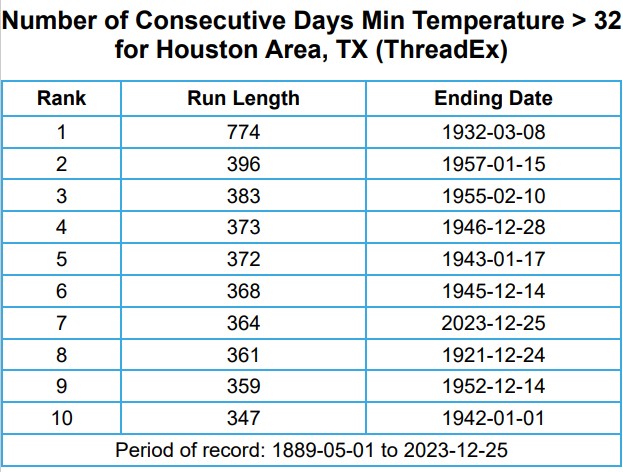
As for a freeze, Houston has not recorded one this calendar year at its official weather monitoring station, Bush Intercontinental Airport. Our current streak of daily minimum temperatures above freezing is 364, dating back to December 26 of last year. Houston has gone a full calendar year without a freeze before, but it’s quite rare. It happened once in the 1930s, and once in the 1950s. The city’s longest streak of days with a minimum temperature above freezing, 774 days, was finally snapped on March 8, 1932. The second longest streak is 396 days, ending on January 14, 1957. Our current streak ranks as the seventh longest on record. There’s maybe a one-in-three chance we snap it this week, I’d say.
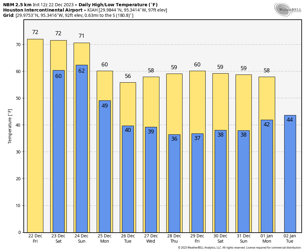
Tuesday
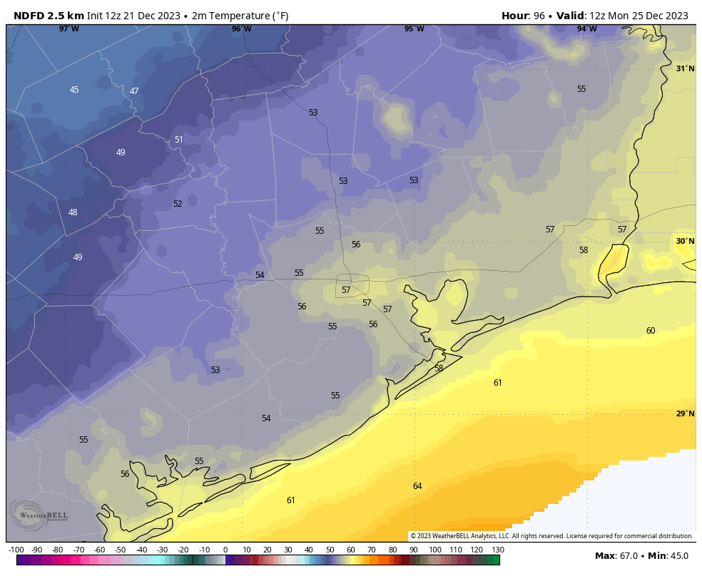
Today should be another day with highs in the upper 50s to 60 degrees, with a light northerly wind. On Monday we saw some lingering clouds, due to a frothy jet stream high above, and we may see some more today. With partly cloudy skies tonight, look for lows to drop into the low 40s for much of Houston again.
Wednesday
I expect a fully sunny day, with highs in the low 60s. Winds will generally be light, out of the northwest. There is plenty of cold air aloft in the atmosphere, and that should help cool down temperatures on Wednesday night into the upper 30s for much of the metro area, with cooler conditions further inland, and warmer ones near the coast.
Thursday and Friday
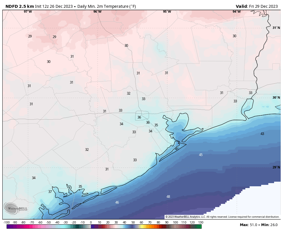
The end of the week looks downright chilly as a reinforcing front comes through. Both days should see highs in the 50s, with sunny skies. The real question comes at night, when there’s the possibility of a light freeze in the Houston metro area, and a bit of a harder freeze further inland. It is going to be a close call. Right now I’d go with lows on both nights of about 35 degrees in the urban center of Houston, with colder conditions for outlying areas. If you’re in areas such as Katy or The Woodlands, I’d definitely plan on the distinct possibility of a freeze. Areas closer to the coast should stay warmer. Needless to say, we’ll continue refining the forecast this week.
Saturday, New Year’s Eve, and New Year’s Day
By the holiday weekend we should be warming up, with a fair amount of sunshine. Saturday should be sunny, with highs in the low 60s. Lows on Sunday morning will drop only into the 40s. Daytime temperatures on New Year’s Eve will rise to about 70 degrees, give or take, with partly sunny skies. The next front may arrive late on New Year’s Eve or early on New Year’s Day, and its timing will in part determine our weather for the holiday. Fortunately, it doesn’t look like the frontal passage will be too messy. So right now I’d expect temperatures in the 50s to ring in the new year. Although we cannot entirely rule out some rain with the front, overall chances are fairly low, so I’m cautiously optimistic about holiday celebrations.
As for the start of the new year, the forecast starts to get fuzzy, but I expect we’ll see a mix of sunshine and clouds with temperatures in the 60s. It will be cool, but probably not cold. The atmosphere starts to get a little more active next week, so by Tuesday or Wednesday we should start to see our next really decent shot of rainfall.