A tale of three fronts, a late-week warmup, and the potential for some storms this weekend

Good morning! Houston will see generally calm weather this week, with cooler temperatures prevailing until Thursday or Friday. We’ll warm comfortably into the 70s to start the weekend before the arrival of a fairly robust cold front on Saturday. I’m keeping an eye on the potential for storms with the front’s passage, although the gnarlier weather may remain north of the Houston metro area. Sunday and the first half of next week will turn chillier.

Monday

High temperatures today will be a touch cooler than Sunday, reaching the upper 60s for most of the metro area. This is because a front is pushing through Houston, to keep our air on the drier side of things. There isn’t enough moisture to produce any rain, and we should end up with partly to mostly sunny skies today. Look for high temperatures in the upper 60s, with generally northerly winds. The cooler and drier flow should allow lows to drop into the upper 40s tonight.

Tuesday

This will be a sunny day, with highs near 70 degrees, and light northeasterly winds. Another shot of drier air arrives later on Tuesday, with a reinforcing front. This should push lows on Tuesday night into the upper 40s again.

Lows on Wednesday morning should be the coldest of the week. (Weather Bell)

Wednesday

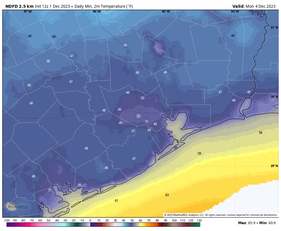
Due to the second front, on Tuesday, this day will be cooler. Look for highs, perhaps, in the mid-60s along with sunny skies. Lows on Wednesday night will drop to around 50 degrees, with cooler conditions for outlying areas. This will mark the beginning of a warming trend as the onshore flow resumes.

Thursday

With that more southerly flow we’ll start to see humidity increasing a bit on Thursday, with highs in the low 70s. Winds will start to become a little more gusty as well, coming from the south. Lows on Thursday night will likely only drop to around 60 degrees.

Severe weather outlook for Saturday and Saturday night. (NOAA)

Friday and Saturday

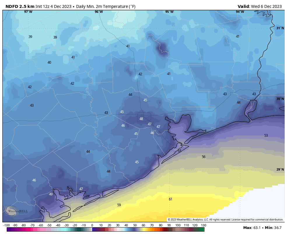
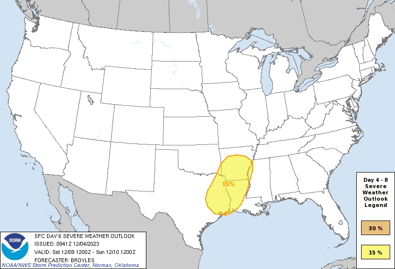
The end of the week will be warmer, with highs in the mid-70s or so, and fairly humid air. Winds will also be more pronounced from the south ahead of a cold front that is likely to push through some time on Saturday. The timing is to be determined, of course, but this front will bring some healthy rain chances, gusty northerly winds, and the chance for some severe weather. The extent of thunderstorms, some possibly severe, will depend on the instability available in the atmosphere. That is difficult to forecast this far out. However, this is something to watch for, and take into account if you have outdoor plans on Saturday. We’ll of course fine tune this forecast as the week goes on. Conditions will turn windy and cold after the front’s passage, with Sunday morning’s lows likely dropping into the 40s.

Next week

We’ll see a colder start to next week, with highs in the 50s or 60s, and lows in the 40s before a warming trend begins around Tuesday or so. A handful of readers have asked about a Christmas forecast, and I’m sorry to say that three weeks out I just have no confidence in making any predictions. I’ll make an initial forecast one week from today.

After Thursday’s heavy rains near the coast, more showers may be on the way this afternoon

Good morning. As usual, weather prediction remains a challenging enterprise. Thursday’s forecast outlined two risks for the Houston metro area: heavy rainfall and severe storms. The former definitely delivered, but the severe thunderstorms underperformed due to a lack of instability. However, even the heavy rainfall was a mixed bag. If you’re reading this from Montgomery or Cypress, you’re probably asking, what heavy rain?!? But if you live in Galveston or League City or La Porte, you know what’s up. Many locations in these cities received 4 or more inches of rainfall on a very soggy day. My backyard is a swamp this morning and the dogs are loving it. So it goes on the Gulf Coast.

The southeastern quadrant of the Houston area won the rainfall ‘lottery’ on Thursday. (HCOEM)

Before jumping into the forecast, I would be remiss in not mentioning our annual fundraiser one final time. It ends today—yes, we’ll stop nagging you—and I want to thank you with a full heart for your generous support. Rest assured the site will be in good stead, financially, heading into 2024 and whatever that years holds weather-wise. If you have not contributed yet and would like to, please visit our store to buy merchandise or make a donation.

Friday

It’s a muggy, foggy mess out there for most of the region with dewpoints and temperatures sitting at about 70 degrees. The fog may hang around until around 9 a.m. or so before temperatures rise enough for it to begin to dissipate. Highs today, however, will only reach the low 70s with persistent clouds.

We have a couple of things to watch for today. First up is a weak front that is going to slowly sag into the region, bringing slightly drier air. This front, in turn, will increase chances for showers and thunderstorms as atmospheric moisture levels remain elevated. These chances, unfortunately, will be highest in coastal counties that received the heaviest rainfall on Thursday. Another 0.5 to 1.5 inch of rain is possible for some locations south of Interstate 10 this afternoon and early evening. Some light rain chances will linger overnight as lows drop to about 60 degrees in Houston.

Saturday

This will be another day of mixed bag weather. The front is going to hang around the coast, so while inland areas will see some moderately drier air, areas south of Interstate 10 should remain somewhat humid. Highs will probably reach the low 70s, and I can’t entirely rule out some light showers along the coast. Those chances will finally end Saturday evening as a reinforcing front arrives with drier air. Lows on Saturday night should drop into the 50s.

Sunday

Skies should be partly sunny for the latter half of the weekend, which seems only fitting since the day’s name is Sunday. Humidity levels will drop noticeably with the second front. We’ll see highs in the upper 60s and light northwesterly winds. Lows on Sunday night will drop to around 50 degrees in Houston, with cooler conditions for outlying areas.

Low temperature forecast for Monday morning. (Weather Bell)

Next week

Our weather for next week looks rather fine. We’re going to see plenty of sunshine for most of the week, with highs generally in the 60s and lows in the 40s and 50s. A series of fronts may actually bring the coldest air to Houston by midweek. Rain chances look low to non-existent for much of the week. They may start to rise by next weekend, along with humidity. Daytime highs may reach the mid-70s, or so, by Saturday. Have a great weekend, everyone!