Storms hitting northern areas should wrap up this evening, with focus likely shifting to the coast overnight

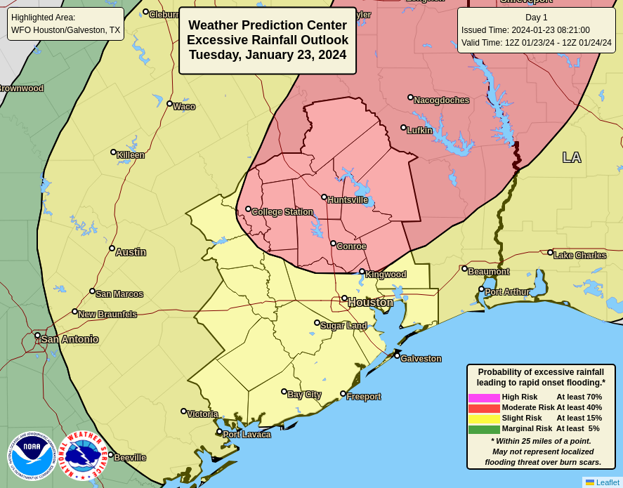
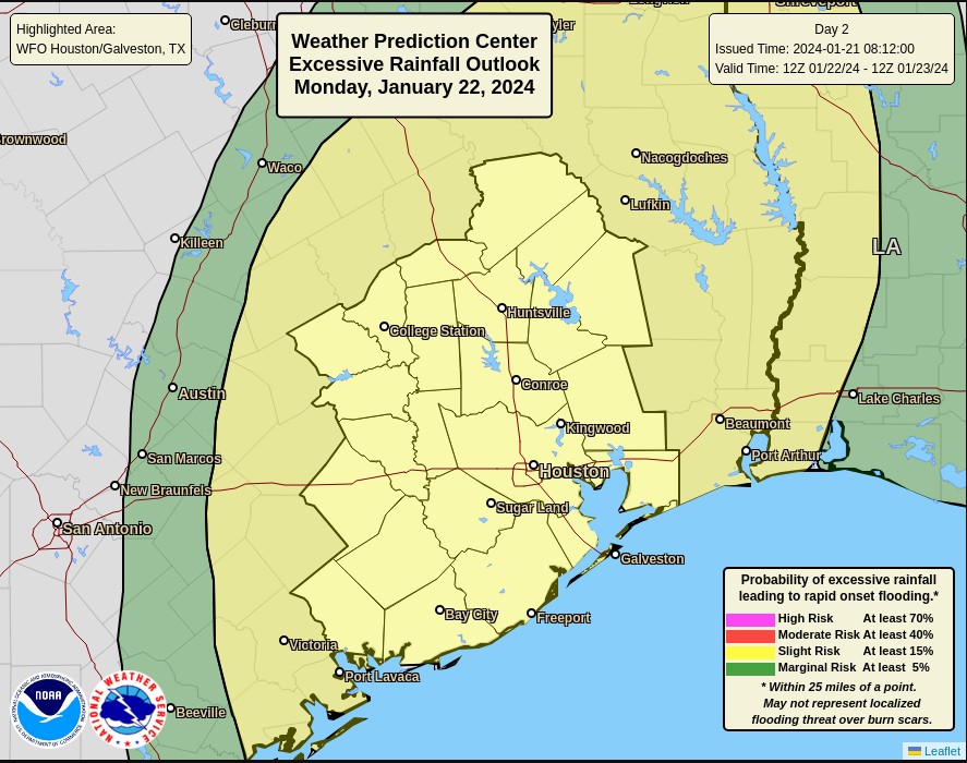
Summary: As expected, much of the storm action has remained north of Interstate 10 today, and that’s where the focus will likely stay through the evening. However, after a lull through the late evening hours, a strong storm system will move in from the southwest, affecting primarily coastal regions. We are maintaining a Stage 1 flood alert through Wednesday night.

Tuesday evening

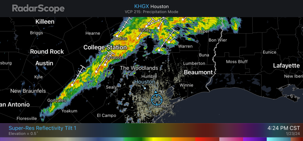
A line of storms is draped across the northwest periphery of the Houston region, affecting areas such as Brenham, College Station, and Huntsville. This system should persist through the evening hours, mostly remaining to the north of Interstate 10, and likely weakening over time. An additional 1 to 3 inches of rainfall are possible for these areas between now and midnight.
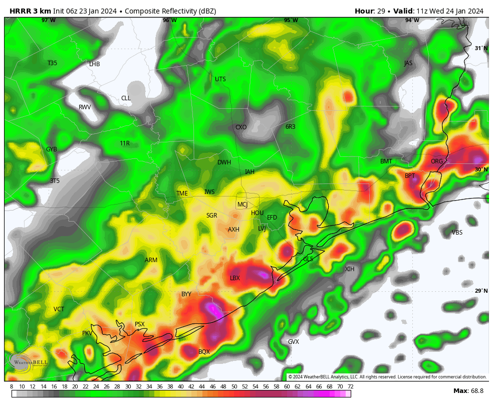
Houston radar at 4:24 pm CT. (RadarScope)

Early on Wednesday

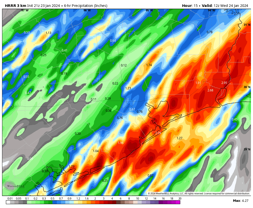
For a few hours around midnight, our area may see a bit of a lull, but then another storm system will be moving in from the southwest. This one is likely to develop near Matagorda Bay around midnight, and steadily progress to the northeast during the pre-dawn hours, bringing strong storms to Galveston and other coastal areas, and the potential for strong storms along and south of Interstate 10 in the Houston metro area. Some of these storms will likely be intense, with some high rainfall rates.

The only good news I can offer is that the system looks fairly progressive, so it should push off to the east by around sunrise on Wednesday. Therefore I don’t expect (too much) mayhem for Wednesday morning’s commute. In terms of accumulations, we could see 1 to 3 inches in the coastal counties by Wednesday morning, with the possibility of some higher bullseyes.

HRRR model forecast for rain accumulation for the six hours between midnight and 6 am CT on Wednesday. (Weather Bell)

Later Wednesday and Thursday

Things may settle down a bit on Wednesday in the Houston metro area, but we’re likely to continue to see at least some disorganized showers and possibly thunderstorms. Coastal counties may see another round of storms late on Wednesday evening or early on Thursday, but I don’t have great confidence in that forecast just yet.

A weak front arrives on Thursday morning, and this should push all of the rain showers to our east sometime during the morning hours. Phew—I can’t imagine too many people will complain about seeing the backside of rain showers for a little while.

We’ll be back with a comprehensive update early on Wednesday morning.

Greater Houston region faces evolving threat from heavy rainfall

Summary: The Houston area picked up 1 to 4 inches of rainfall on Monday, and we’ll see ongoing bursts of precipitation through Thursday morning. Today the focus shifts north of the metro area, to areas including The Woodlands, Kingwood, and College Station. By Wednesday morning the threat appears to be more centered on coastal areas, including Galveston. We’re maintaining a Stage 1 flood alert for now, but will continue to monitor things closely.

Tuesday

Things are fairly quiet just before sunrise this morning, but showers and thunderstorms are developing to the west of the area in response to disturbance that will move through the region today. This feature will likely bring 1 to 4 inches of rain to areas north of Interstate 10, with the highest totals likely near locations such as College Station and Huntsville. In Houston I expect a somewhat calmer day, with 1 inch of rain or less in the city on down to the coast.

Excessive rainfall forecast for Tuesday. (NOAA)

Temperature-wise, today will be fairly warm for January, with highs of about 70 degrees. Skies will be cloudy, with southeasterly winds occasionally gusting to 15 or 20 mph. Low temperatures tonight will only drop into the mid-60s, with continued humid air. Storms will be possible after midnight in the metro area, which I’ll discuss below.

Wednesday

High-resolution models are indicating the development of strong showers and thunderstorms early on Wednesday morning for locations along and south of Interstate 10. While we cannot have great confidence yet, it does look like coastal areas from Port Lavaca to Galveston to Beaumont could see heavy rainfall during the pre-sunrise hours. Some of these storms could well migrate northward into the Houston metro area, setting up the potential for a messy commute on Wednesday morning.

In any case, unlike Tuesday, Wednesday looks rather wet in the Houston urban area, with the potential for street flooding. If there’s more clarity later today we may post an update. I expect additional accumulations of 2 to 4 inches of rain, with higher totals possible near and along the coast. It will be another warm-ish and humid day for most of Houston, with highs of about 70 degrees, but it may be a bit cooler to the northwest of the city.

HRRR model depiction for radar reflectivity at 5 am CT on Wednesday. For illustration purposes only. (Weather Bell)

Thursday

A weak front that will move into the Houston region and stall northwest of the area should finally push through the city early on Thursday morning. I expect this to drive one more round of showers and thunderstorms during the pre-dawn hours before this mess finally exits to the east. Look for partly clearing skies later in the day with highs in the 60s. Lows on Thursday night should drop into the 50s.

Friday

Expect a partly sunny day with highs of around 70 degrees. We’ll see a chance of showers later on Friday and Friday night as a second, stronger front approaches the area. Right now accumulations don’t look too significant, but we’ll see.

Saturday and Sunday

The weekend should see mostly sunny, winter-like weather. Look for highs in the mid-60s on Saturday, with a northerly wind gusting at times to 20 or 25 mph. Lows drop into the 40s overnight, with highs on Sunday reaching the lower 60s. I’m looking forward to taking advantage of the sunnier and mild weather with a long bike ride.

Next week

Look for calm weather to prevail through Wednesday, with highs generally in the 60s and lows in the 40s. A warming trend begins later on Wednesday or Thursday with some slight rain chances returning by Thursday or so. All in all, it should provide a nice run of pleasant weather after this turbulent week.

Heavy rainfall threat moving into the Houston area this morning

Summary: Rain showers are moving into the Houston area from the west, and we’ll see the threat of heavy rainfall from now through Wednesday. It will be a decidedly soggy period, and we have instituted a Stage 1 flood alert to account for the potential of street flooding.

Monday

As expected, an upper-level storm system is inching toward our area, and this is producing widespread showers to the west of Houston. These showers and thunderstorms will spread across the metro area this morning and remain with us for much of the day. I expect most of the area, from the Brazos Valley on down to Galveston, to pick up 1 to 4 inches of rainfall today and this evening. Rain chances are effectively 100 percent with a saturated atmosphere and ample sources of lift. The one good thing I can say about the showers is that, generally, individual storm cells should push through fairly quickly from west to east. So the overall threat of ‘training’ storms is lower. There may be a brief lull in rain showers this evening or during the overnight hours before a second round of showers pushes in early on Tuesday.

Pretty much everyone is at risk of heavy rainfall on Monday. (NOAA)

In terms of temperatures, after a cold weekend, we’re seeing a surge of warmer air that will remain with us for most of this week. Highs today should reach the low- to mid-60s, with low temperatures tonight only dropping to around 60 degrees. Winds will also be noticeable today, blowing from the southeast at 15 or 20 mph, with gusts up to 30 mph. So yeah, not a great day for a picnic.

Tuesday

This will be another day that favors widespread rainfall. However, it’s possible that this setup will produce higher rain totals to the north of Interstate 10, and areas further inland, instead of closer to the coast. In any case, much of the area could pick up an additional 1 to 3 inches of rainfall. Highs will again be in the 60s to near 70 degrees. It’s possible that we see another lull in rain chances during the evening or overnight hours.

The story is the same for Tuesday. (NOAA)

Wednesday

This should be the region’s final day of widespread showers, although conditions look marginally less favorable than on Monday and Tuesday. Still, pretty much everyone is going to see rain, with totals in the vicinity of 0.5 to 2 inches, probably. Highs will be in the upper 60s. I expect most people to pick up 4 to 6 inches of rainfall through Wednesday, with some areas seeing greater bullseyes.

Thursday and Friday

These will be a pair of partly sunny days, with highs around 70 degrees, slightly less humidity, and nights in the 50s. Rain chances won’t go away entirely, but they should drop down to about 20 or 30 percent each day.

Saturday and Sunday

Saturday should be partly sunny, with highs perhaps in the 60s. We’ll see a decently strong front push through sometime during the early morning hours or daytime, and there may be a smattering of rain with the front. Afterwards lows drop into the 40s. Sunday should be sunny, with highs perhaps around 60 degrees.

Next week

Most of next week looks quiet, with highs in the 60s and lows in the 40s. Rain chances look fairly low through at least Wednesday or so, giving us some needed time to dry out.

Site note

Matt and I will be monitoring today’s rainfall closely, and if an update is needed to our flooding expectations, we’ll update accordingly.

Widespread rain showers likely on Monday: We’re issuing a Stage 1 flood alert

Summary: Today will be cloudy and cold, but there should be no issues with outdoor activities. That begins to change tonight and especially on Monday morning, as a storm system moves in from the west. Expect on-and-off showers, along with heavy rain and potentially some street flooding through the middle of the week.

Sunday

Most of the region is starting out in the mid- to upper-30s this morning, and we’re going to see overcast skies. This will help to limit highs in the low 50s today, with an easterly breeze, perhaps gusting to 20 mph at times. From there, temperatures aren’t going to fall much tonight, if at all. Any rain showers should hold off until after midnight.

Monday

This is the day we expect the heaviest and most widespread rain to fall in Houston this week. An upper-level system will bring favorable conditions for rainfall, and this should spread into the region during the morning hours. At this point I expect a mass of showers to congeal west of Houston before sunrise, and potentially reach areas such as Katy by around 6 to 8 am. Please understand that these times are approximate, and there is the potential for some messy commuting on Monday morning.

We should see widespread showers and thunderstorms for pretty much all of the daytime hours in Houston, and I expect most of us to pick up 2 to 4 inches of rainfall. That should be mostly manageable, but we have a few concerns. One is that some areas may see bullseyes of 5 inches or more. The second concern is that the ground is hard from our recent freezes, so instead of soaking up a lot of this rainfall, the water will run off. So 4 inches of rain in January will back up much more quickly than 4 inches in August.

Excessive rain outlook for Monday and Monday night. (NOAA)

For this reason we’re issuing a Stage 1 flood alert for Monday due primarily to the potential for street flooding. It will be a good day to be weather aware before heading out. Certainly not everyone will see impacts, but the potential is there.

Tuesday and Wednesday

After a possible lull on Monday evening, we are likely to see additional rounds of showers from the period of Monday night through Wednesday. It’s a little early to have much confidence in the contours of these additional periods of rainfall, but it’s my hope that they won’t be quite as intense on Monday.

In terms of temperatures, we’re going to be much milder after Sunday. Expect highs in the 60s with lows in the upper 50s. Conditions turn a bit cooler by the weekend, probably.

All told, I expect the Houston region to pick up between 4 and 8 inches this week. Matt and I will be monitoring the situation closely today, and the rest of the week to ensure that you remain on top of conditions. We will update the site, and our flood scale predictions, as warranted.