Once Francine passes to our north, summertime temperatures will return for a good spell

In brief: Francine is making its closest approach to the Houston area this morning, but remains a non-issue for the state of Texas. We’ll see one more cloudy and somewhat cooler day, with a chance of showers, before summer returns for a spell. We look to be solidly in the 90s for awhile after today.

Francine status

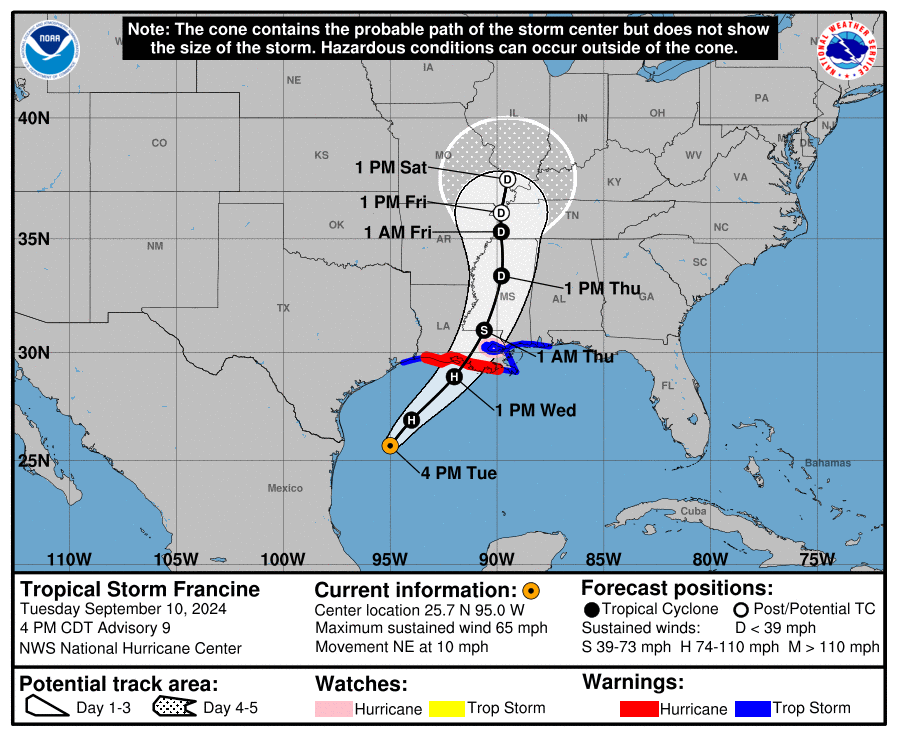
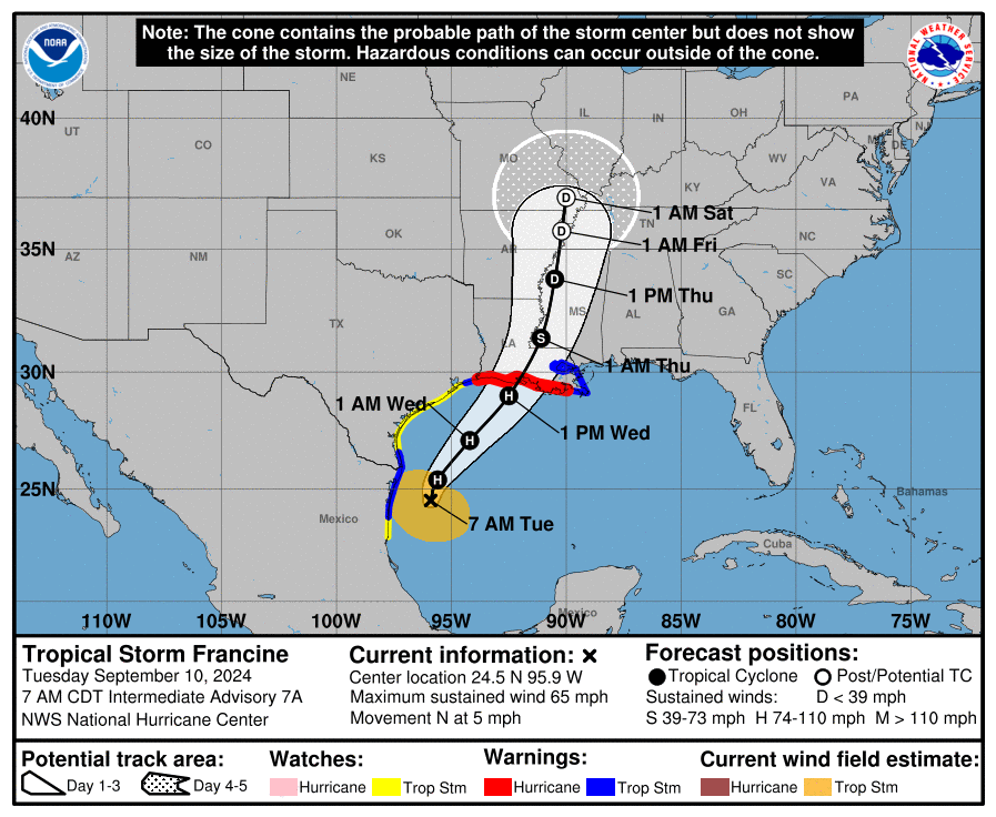
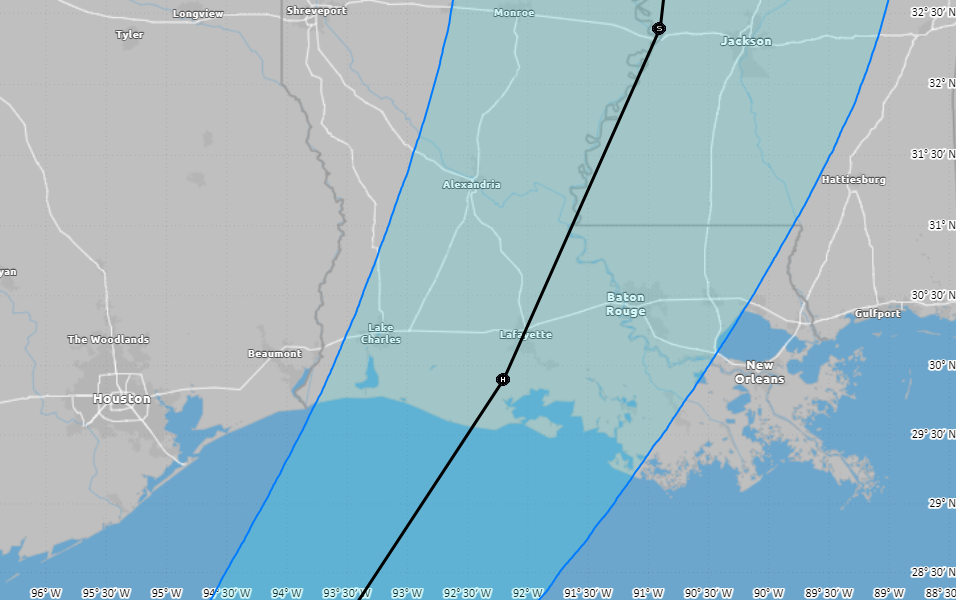
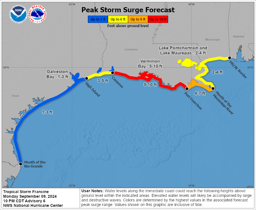
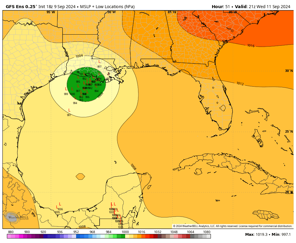
Francine has substantially increased in intensity overnight, reaching 90-mph winds. It should become a Category 2 hurricane before reaching the Louisiana coast this afternoon or evening. The storm will bring serious impacts to major populated areas of the state, including Baton Rouge and New Orleans. We will provide continuing coverage of these impacts on The Eyewall.

Hurricane Francine is approaching the northern Gulf Coast this morning. (NOAA)

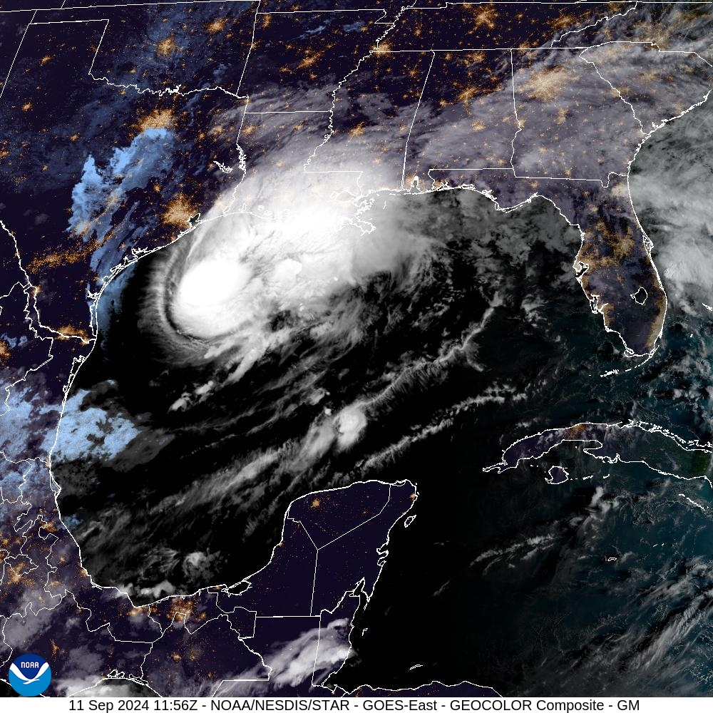
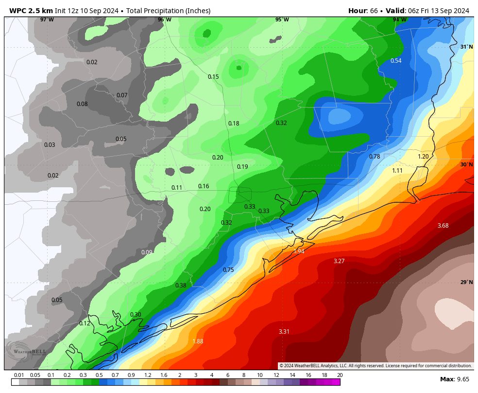
Locally in the Houston area, the impacts have been minimal. The storm’s center is now making its closest approach but is still more than 150 miles off the coast from Galveston. We have seen some slightly elevated winds—there was a single gust of 38 mph in Galveston last night—but for the most part sustained winds even along the coast have been 15 to 20 mph. For all practical purposes it has been a non-event locally.

Wednesday

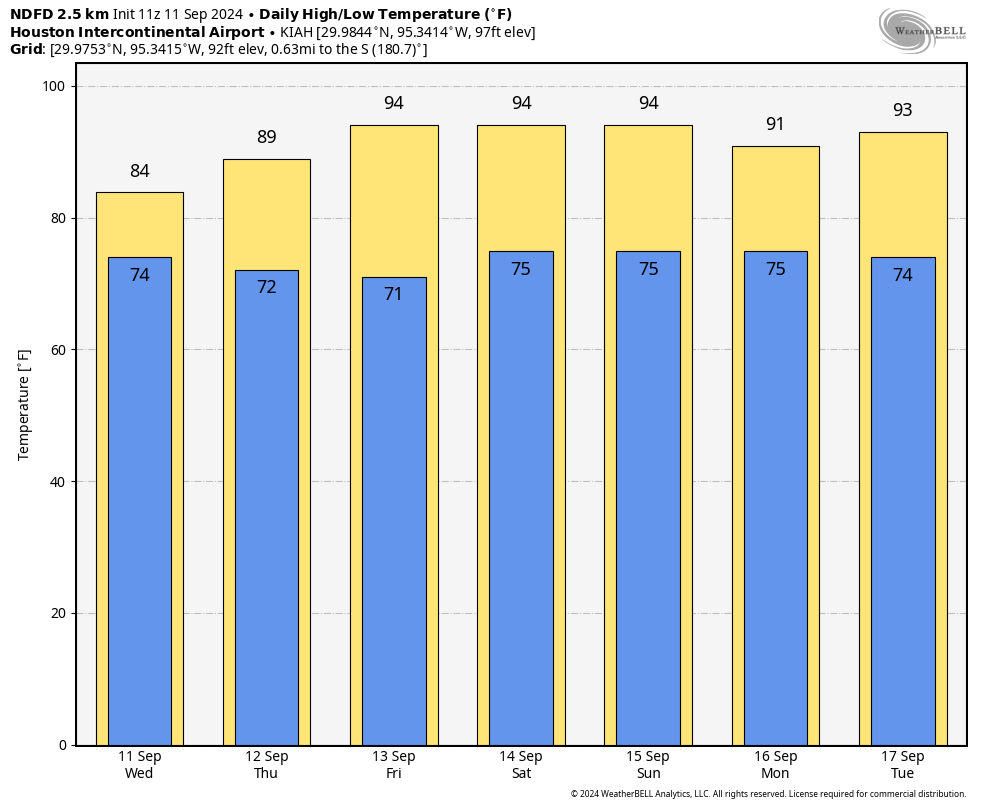
We’ll see mostly cloudy skies today, and that will help to keep high temperatures in the mid-80s. We’ll continue to experience north-northeasterly winds from the hurricane’s passage, and at times these could produce gusts of 20 to 25 mph. However, there will be nothing too out of the ordinary from this. Finally, we’ll see some scattered, mostly light to moderate showers throughout the day today. But overall rain chances for any given location are probably 50 percent or less. Low temperatures tonight will drop into the low 70s.

Thursday

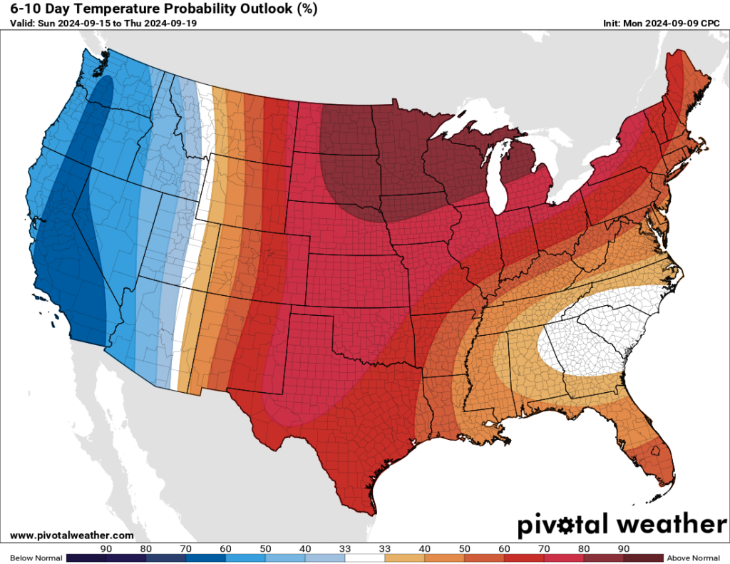
Due to rains in late August and early September, and then the passage of Hurricane Francine, the Houston area has experienced a stretch of mostly 80s-days in terms of temperature. But just as a reminder, we’re still in September, and summer is not in fact over. We’ll be reminded of that, beginning Thursday, as the mercury starts to climb again. Highs will reach about 90 degrees, with mostly sunny skies and plenty of humidity. Lows will drop into the mid-70s.

Welcome back, summer. (Weather Bell)

Friday, Saturday, and Sunday

The weekend looks hot and sunny, with high temperatures in the low- to mid-90s. This will be due to Houston falling under the influence of high pressure. A very slight chance of rain returns to the forecast by Sunday, but it’s probably only 10 or 20 percent.

Next week

Houston could see a weakness in the high pressure system by the early part of next week, which could bring perhaps a 30 percent chance of showers for a few days. But for the most part of next week I expect partly to mostly sunny skies, with highs in the low- to mid-90s. There is a chance of a front about 12 to 14 days from now, but only a chance.

After Francine, the Gulf of Mexico should quiet down for a bit. (National Hurricane Center)

Tropics

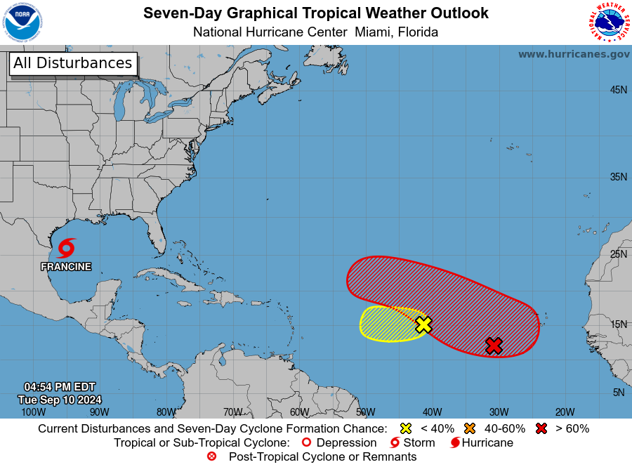
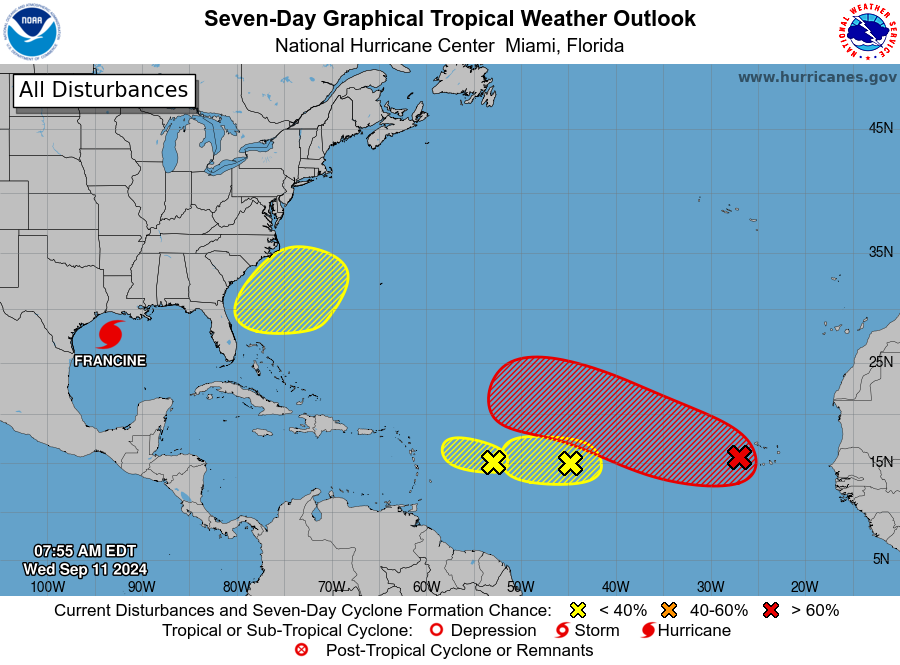
Beyond Francine the National Hurricane Center is starting to track more potential areas of development. However, at this time I don’t see any particular threats to the Gulf of Mexico. For this time of year, that’s a great place to be.

Francine will make landfall in Louisiana tomorrow. Is anything coming behind it?

In brief: This is a short post to wrap up our coverage of Tropical Storm Francine, which as expected is having a negligible effect on Texas as it remains well offshore. We also take a look ahead at potential tropical activity over the next 10 days or so.

Francine forecast

As of late this afternoon, Tropical Storm Francine is located due east of the mouth of the Rio Grande River, about 135 miles off the coast. This is about as close as the storm is going to get to Texas as it has assumed a northeastward movement that will take it toward the Louisiana coast. Forecasters at the National Hurricane Center expect the storm to reach the south-central coast of Louisiana by Wednesday afternoon as a Category 1 hurricane.

The official forecast for Francine is locked in on Louisiana for a final landfall. (National Hurricane Center)

We have been, and will continue to cover the implications of Francine for Louisiana on our sister hurricane website, The Eyewall.

Houston-area impacts

Not much. We’ve seen some sporadic showers today, and that will continue tonight and into Wednesday morning. Inland winds will not be far above normal levels, and even along the coast I don’t expect gusts to exceed 35 or 40 mph, which is not something to be overly concerned about. Tides will run 1 to 3 feet higher than normal tonight and Wednesday morning.

All of this, to the extent that there is anything, will be gone by Wednesday afternoon. The main impact from Francine for Houston is lower temperatures, with highs in the mid-80s today and Wednesday. We’ll be back in the low- to mid-90s soon, so enjoy this.

Beyond Francine, there’s not much for Texas to worry about. (National Hurricane Center)

What’s next in the tropics?

In short, not much we need to worry about. The National Hurricane Center is tracking a couple of areas of low pressure in the Central Atlantic Ocean. However, none of the reliable models bring either of these systems, if they develop at all, toward the Gulf of Mexico. Beyond that, the Gulf of Mexico looks pretty quiet for the next ten days. We’re getting closer to the end of the tropics season for Texas, which is great. But we’re not there yet.

Francine now turning, and will remain far off the Texas coast. Houston to see minimal effects

In brief: Francine remains a strong tropical storm this morning, and we’re beginning to see the turn from northwest movement, to northern movement, to northeast that will ultimately carry the storm well away from Texas. Local impacts, for many not along the immediate coast, will be difficult to discern from a regular late summer-day in Houston.

Francine status and forecast

The overall forecast for Francine remains much as we have been saying for a couple of days now. The tropical system will remain well offshore from Texas, and effects for most of our area will be minimal. In fact, I would go so far as to say that by tomorrow people in Houston will be going, “Hurricane? What hurricane. This was a joke.” Well, people who didn’t know better will be thinking that at least—but not readers of this site.

Francine, almost certainly at hurricane strength, will come ashore in Louisiana some time on Wednesday. (National Hurricane Center)

Francine will not be a joke for southern Louisiana. The tropical storm has sustained winds of 65 mph, and is likely to move inland Wednesday afternoon or evening as a Category 2 hurricane. The state’s most populated area, from Baton Rouge to New Orleans, will be directly impacted with winds, rains, and storm surge. For complete coverage of these impacts to Louisiana, be sure to check our ongoing coverage at The Eyewall later this morning.

Tuesday and Wednesday

There are showers just offshore the Texas coast this morning, and the question is how far rains from Francine will penetrate inland into the Houston metro area today and tomorrow. The answer, I think, is not all that far. Based upon high resolution modeling, I expect to see a band of showers reach the coast around noon today, and then fall apart fairly quickly as it moves inland. Then, the region will see scattered rain chances through Wednesday evening. All in all, I could see the coast picking up 1 to 2 inches of rain, with inland amounts significantly less. Areas such as Katy or Tomball may not see any rain at all.

NOAA rain accumulation forecast for now through Thursday. (Weather Bell)

In terms of winds, I don’t expect much. If anything, the eventual track of Francine has pushed further to the east over night, and this really keeps the stronger winds at bay. We could see gusts of 25 mph or so in the city of Houston by Tuesday night, and perhaps 30 to 40 mph along the coast. But I don’t expect conditions seriously worse than this, and these kinds of winds will be fine if you need to be out and about. Seas will rise 1 to 3 feet above normal at high tide for coastal areas, including Galveston Island and Bolivar Peninsula.

The bottom line is that, for most of the Houston area, you won’t be able to tell there’s a hurricane passing offshore today and tomorrow. Skies will be mostly cloudy, with highs in the mid-80s, which is cooler than normal for this time of year. Perhaps that’s our greatest takeaway from this storm, some slightly cooler days. I’m not complaining.

Thursday

We may see a few lingering showers on Wednesday night, but by Thursday we should see sunny skies and light, northwest winds at 5 to 10 mph. Highs will reach about 90 degrees.

Friday, Saturday, and Sunday

The weekend looks hot and partly to mostly sunny. Daytime temperatures will get into the low-90s for most locations, with nighttime temperatures in the mid-70s. If I squint I can make out a slight chance of rain returning to the forecast by Sunday, but it is probably only in the vicinity of 10 to 20 percent.

Temperatures will be warmer than normal next week. (Weather Bell)

Next week

I don’t see much of a pattern change next week, as highs should remain in the low 90s, with low-end rain chances and plenty of sunshine. This is fairly typical, if slightly warmer than normal weather for mid-September, and should be good for the pool, beach, or whatever outdoor water activities you care to partake in.

Next update

We’ll have a brief update on Francine later this afternoon. Don’t expect any significant track changes that will impact Texas, however.

Yes, it still looks like Francine will not mess with Texas. Also, your burning questions are answered

In brief: The overall track forecast for Francine remains more or less the same, with the storm very likely to remain off the coast of Texas, and strike southwestern or south central Louisiana on Wednesday. This post discusses the impacts to Houston, and answers some of the burning questions we’ve received about Francine, including “western” shifts and such.

Francine status

Francine’s intensity remains just below hurricane strength, with 65 mph sustained winds, at 10 pm CT. The storm is moving to the north-northwest at about 5 mph, according to the National Hurricane Center, and it soon should begin a turn to the north, and then the northeast.

Zoomed in track forecast and cone for Tropical Storm Francine at 10 pm CT Monday. (National Hurricane Center)

Track and intensity outlook

The National Hurricane Center track forecast has not changed much since this afternoon, aside from a slight eastward shift. At this time the entire state of Texas is now outside the cone of uncertainty. The storm’s forward motion on Tuesday night and Wednesday is now expected to be a little faster than normal, so Francine could reach the Louisiana coast as early as the afternoon hours on Wednesday. For more information on impacts to Louisiana, which could be severe, please check out our companion site The Eyewall.

Houston impacts

There is not much change in outlook. We could see some showers and thunderstorms moving into Houston tomorrow by or before noon from the Gulf of Mexico. Frankly, these storms don’t look too organized or problematic. Areas nearer to the coast are more likely to see rain, with the potential for 1 to 3 inches, and possibly a few higher bullseyes. Further inland, showers will be hit or miss. Scattered rain shower chances will persist overnight and through much of Wednesday, but this does not look to be a washout for anyone.

In terms of winds, there probably won’t be much to worry about in the city of Houston. Down closer to the coast we could see some sustained winds of 30 or 35 mph, with higher gusts, but that probably is the worst case scenario. The strongest winds will likely push through on Tuesday night. Seas should be 1 to 3 feet above normal along Galveston Island and Bolivar Peninsula, and a bit higher further to the east toward Cameron, Louisiana.

Storm surge forecast for Francine. (National Hurricane Center)

Why is this not a repeat of Beryl?

A lot of people have asked in the comments, and via email, why we’re confident that Francine is going to turn away from Houston. After all, the forecasts were wrong for Beryl, so why not now? There are a couple of answers to this. First of all, the Beryl track errors occurred about four to five days before landfall. We’re now less than two days from Francine making landfall in Louisiana. So confidence is naturally higher with a near-term forecast.

The second reason is that our modeling guidance has been very consistent over the last 24 to 48 hours, and in some cases significantly longer. Whereas there were some outlier model solutions with Beryl that indicated a Houston strike was possible, virtually every model we are looking at indicates that Francine will pass well offshore the Texas coast, and eventually make a landfall in Louisiana. This is a remarkable consensus, and when you have a consensus in a near-term forecast, your confidence is very high.

Looking at this evening’s ensemble forecast from the GFS model, there are no members approaching Texas. (Weather Bell)

With that said, I get that the PTSD from Beryl is very real. Some forecasters, including this site, definitely made some errors with that hurricane. We try to learn from every storm. Most importantly, we want to make sure we have your trust, so that you’ll trust us when we say a storm like Francine is almost certainly going to be fine for Houston.

What about that western wobble earlier Monday?

There was a lot of brouhaha this afternoon about Francine shifting west, and the center wobbling west, and all manner of talk about how the Texas coast was suddenly at risk for serious impacts from this storm. All of this because the National Hurricane Center nudged the official track about 10 to 15 miles westward—a nudge that was more or less meaningless when it comes to Texas impacts.

In fact, as of 10 pm the track shifted back east some, completely erasing the much heralded western “shift” noted earlier today. The bottom line, don’t buy the hype.

Are you guys really sure that Francine isn’t coming to Texas?

We’re sure there are many people named Francine who are coming to Texas in the near future, and we should welcome them with open arms and warm hearts. But yes, we’re pretty darn confident that Francine the named storm is not coming to Texas this week. I mean, there’s a very slim chance it could come ashore in the Beaumont-Port Arthur area, but very likely not.

Really, really sure?

Yes.

Anyone else ready for a Falcon 9 and Crew Dragon launch late tonight? (SpaceX)

But just to be sure, when’s your next update?

Well, I’ve got to stay up to cover the Polaris Dawn launch tonight at 2:38 am CT from Florida. There are four great people launching into space on a Crew Dragon vehicle, and I consider some of them my friends. So I want to see them safely into space. But I aim to have tomorrow’s update posted no later than 7:30 am CT. Wish me luck, y’all!