Francine is racing toward hurricane strength, but still expected to remain offshore the Texas coast

In brief: Francine has rapidly developed on Monday and is nearing hurricane strength. In terms of a track forecast, it still appears as though the tropical system will remain far enough off the Texas coast to spare the Houston region of significant impacts. We’ll continue to watch things closely, however.

Francine status

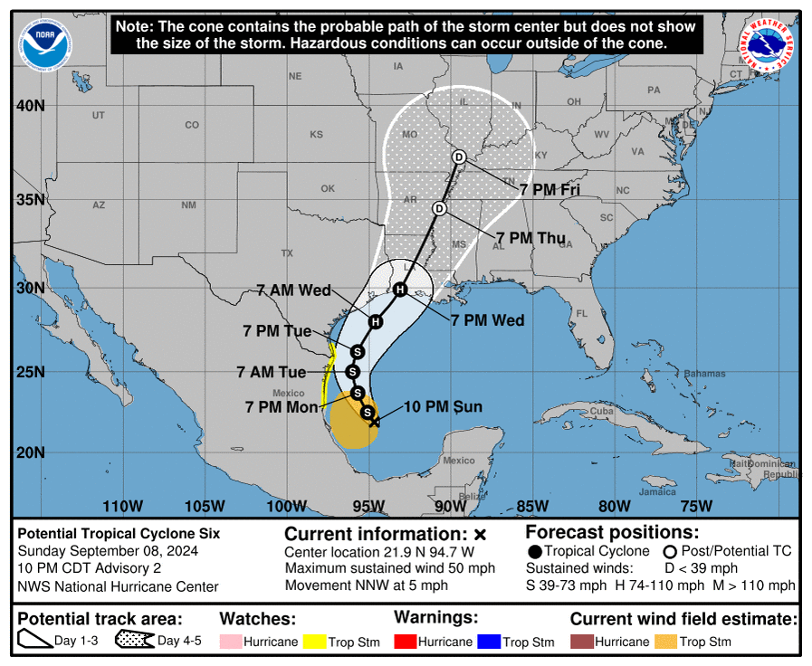
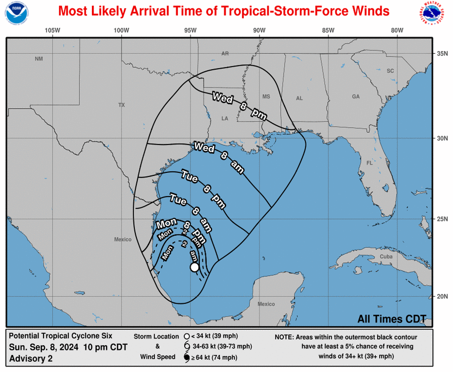
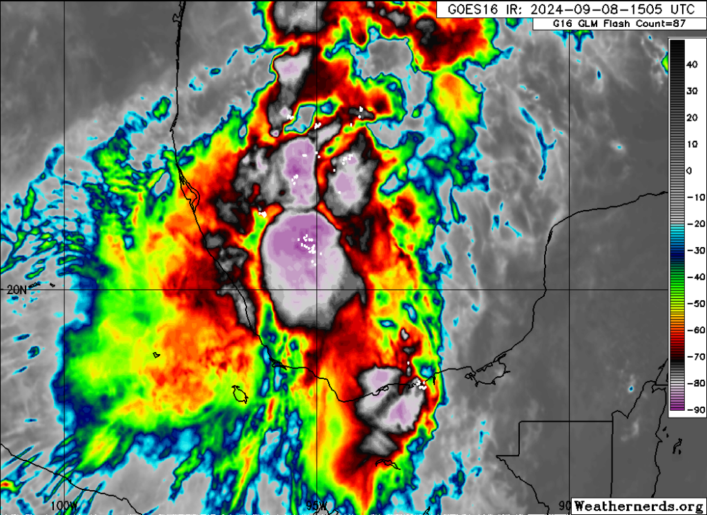
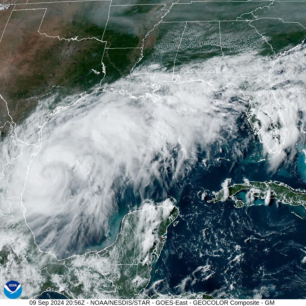
As of 4 pm CT, Tropical Storm Francine is nearing hurricane strength, with 65-mph sustained winds, according to the National Hurricane Center. The storm’s central pressure is dropping, and further intensification is likely. Francine is moving to the north-northwest at 7 mph, and is about 150 miles to the south-southeast of the mouth of the Rio Grande River. Francine has developed an eye this afternoon, which can be seen in satellite images and on the Brownsville radar.

Tropical Storm Francine is covering much of the western Gulf of Mexico on Monday afternoon. (NOAA)

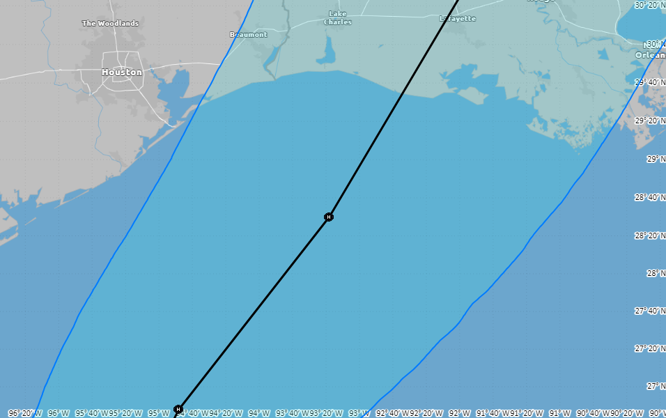
Francine track and intensity

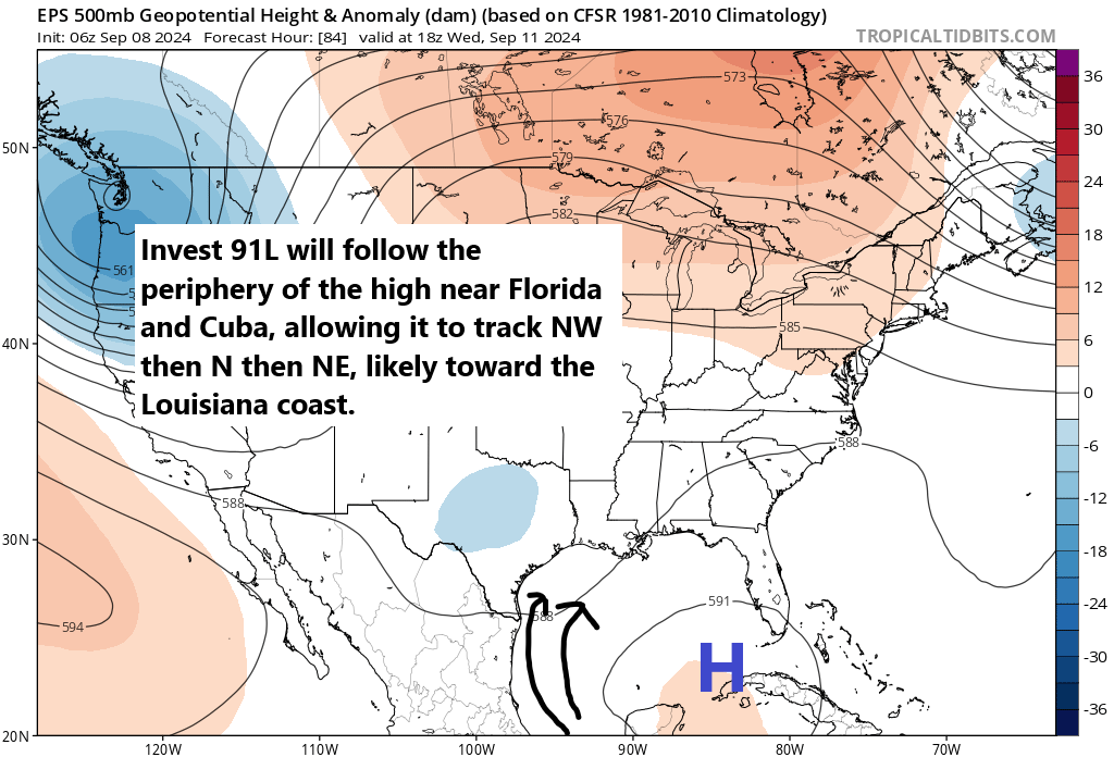
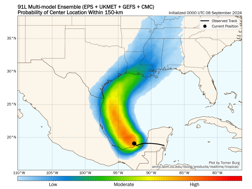
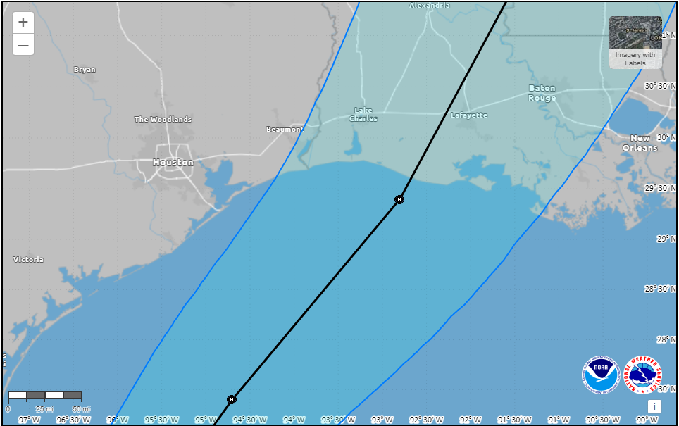
The general forecast for Francine has not changed. The storm is expected to continue moving mostly to the north today and tonight, before making a turn to the northeast on Tuesday. This will essentially allow the storm to track along the contour of the Texas coast, but remain far enough offshore to preclude significant and consequential impacts in terms of rains, winds, and storm surge for most of the upper Texas coast.

By Wednesday evening or night, Francine is expected to reach the southern Louisiana coast, perhaps near Vermillion Bay. It is likely to be a hurricane at landfall on Wednesday afternoon or evening when it comes ashore in southern Louisiana.

Zoomed in 4 pm CT Monday track forecast for Francine from the National Hurricane Center.

Houston impacts

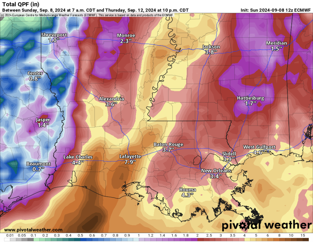
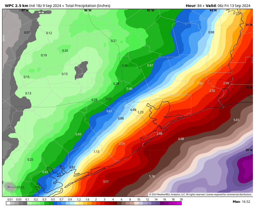
Based upon the latest high resolution modeling, we could start to see some rain bands from Francine moving into Galveston Island and other coastal regions by around mid-morning on Tuesday. My sense is that the vast majority of the region along and inland of Highway 59/Interstate 69 is not going to see much precipitation from this storm, probably 1 inch or considerably less.

Coastal areas have the potential for more, but at this time I would consider the accumulation forecast shown below as a reasonable worst-case scenario. We do not anticipate significant street flooding at this time. Rain is most likely from Tuesday morning through Wednesday morning, after which chances should rapidly diminish.

NOAA rain accumulation forecast for now through Thursday. (Weather Bell)

In terms of winds, I expect gusty winds on Tuesday, but nothing wild. Most of the area, including the coast, probably will see some gusts of 20 mph or above. Winds will pick up Tuesday evening and during the overnight hours, but I think the upper limit is sustained winds of about 40 mph right along the coast, with gusts of perhaps 50 mph. (Winds will be noticeably less inland). These kinds of winds should not be enough to provoke significant issues, although some isolated power issues along the coast cannot be ruled out.

Seas will rise 1 to 3 feet above normal at high tide, so only very low-lying areas should see issues on Tuesday night and Wednesday.

All in all, we continue to believe that Francine will be a manageable storm for most of Houston.

We’ll continue to monitor the situation closely, and if anything changes we’ll have an update later tonight—given the angst and interest out there, we might update this evening regardless. If not, we’ll see you first thing on Tuesday morning.

Tropical storm likely to remain offshore from Texas, ultimately strike Louisiana

In brief: We’re keeping a close eye on the Gulf of Mexico, but all of our best data continues to suggest that a tropical storm forming there will remain off the Texas coast. At this time impacts in Houston look to range from modest to minimal, with rain chances dependent on how far the system remains offshore. After Wednesday, we’re likely returning to sunny skies and highs of around 90 degrees to end the week.

Potential Tropical Cyclone Six

We expect the tropical system developing in the southern Gulf of Mexico to drop the “potential” label and become Tropical Storm Francine within the next day or so.

We have been saying for a couple of days that this system will move near the South Texas coast by Tuesday, but then is likely to remain off the coast as it turns northeast. Almost all of the computer modeling that matters continues to point toward this scenario, which would keep impacts in Houston at a modest level. The forecast could still change, but time is running out for this to happen.

Zoomed in version of the track forecast for a tropical system likely to become Francine. (National Hurricane Center)

So what will this mean for the greater Houston area? Our region is likely to see elevated rain chances on Tuesday afternoon, night, and Wednesday, especially for locations south of Interstate 10. In terms of accumulations, we still need to watch the development of the system, but at this time I don’t anticipate the potential for much, if any flooding, with the possible exception of areas immediately along the coast. As for areas inland of Interstate 10, the rain potential is significantly less.

In terms of seas, we’re likely to see tides elevated 1 or 3 feet above normal levels as the storm passes on Tuesday night and Wednesday. Winds will also be elevated during this time period, especially on Wednesday morning. Galveston Island could briefly see tropical-storm force winds, but I wouldn’t bet on that. These winds will fall off quickly for inland areas. The upper limit for winds in Houston, away from the coast, is probably sustained 15 or 20 mph, with gusts up to 30 mph or so. This should not cause significant issues with electricity distribution.

Forecast for maximum wind gusts from Francine from the European model. (Weather Bell)

For impacts in Louisiana, which could be serious should Francine continue to develop into a Category 1 or Category 2 hurricane, please see our ongoing coverage at The Eyewall.

Monday

It’s a lovely morning in Houston, with temperatures generally in the mid- to upper-60s, and dewpoints in the lower 50s. This first taste of fall over the weekend has been wonderful, but it will soon be gone. High temperatures today will push into the upper-80s under mostly sunny skies, and humidity levels will follow (but it won’t feel Houston humid until Tuesday, as some modestly drier air lingers). Lows tonight will drop into the lower 70s for most of the city. Winds will be from the northeast at about 10 mph, with higher gusts.

Tuesday

Clouds return on Tuesday, and this will help to limit high temperatures to the mid-80s for most locations. We may start to see some rain from Francine by Tuesday afternoon, but this will depend on how well the system organizes, and how far its center remains offshore. These rain chances will persist overnight, with winds increasing in intensity overnight. Lows will drop into the mid-70s.

Wednesday

As described above, this is when the most serious impacts will occur from Francine, to the extent that they occur in Houston at all. Expect cloudy skies and high temperatures in the lower-80s. Rain chances will be high for coastal areas, and healthy for areas south of Interstate 10. I expect the rain to start moving away from our area by Wednesday afternoon or evening. We’ll see. Lows Wednesday night drop into the lower 70s.

Thursday and Friday

These will be a pair of mostly sunny days with high temperatures in the upper 80s to about 90 degrees as Houston lies on the backside of Francine.

Saturday and Sunday

The weekend should see more sunshine, but perhaps a few clouds mixed in as well. We are talking highs of around 90 degrees, with plenty of humidity, and nights with temperatures in the mid- to upper-70s. I can’t entirely rule out some rain, but chances are probably in the vicinity of 20 percent.

Houston is likely headed back to the low-90s this weekend. (Weather Bell)

Next week

I think we’ll remain in a fairly warm, late summer pattern for much of next week with highs in the vicinity of 90 degrees, or low 90s. We’ll see some additional rain chances from time to time, but nothing that looks too extreme. I don’t see much evidence for a cold front within at least the next 10 days.

Note

We will publish an additional update on the tropical system by 4 pm CT this afternoon.

Tropical Storm Francine likely to form off the Texas coast, with a range of local impacts possible

In brief: It continues to look as though formation of a tropical storm in the Gulf of Mexico near Texas will happen soon. At this time, the majority of our modeling guidance still points toward the storm’s center remaining off the Texas coast and eventually moving into Louisiana. This forecast could change, however, and we’re watching closely.

Good evening. It has been a lovely early September day in Houston, and we’ve got about 12 hours more to enjoy the dry air before it exits on Monday morning. As first fall fronts go, this one was fairly standard: short-lived, modestly impactful, but nevertheless deeply appreciated. Alas we now probably will have to wait awhile for the next cool front. And so we turn our attention to the tropics where we have a “potential tropical cyclone.” The National Hurricane Center uses this term to designate a system that is close to land, which it expects to develop, and for which it wants to begin issuing public advisories.

10 pm CT track forecast for Potential Tropical Cyclone Six. (National Hurricane Center)

It has been nearly a month since the last named storm formed in the tropics, Ernesto, back on August 12. But soon, likely within the next day or so, we will have Tropical Storm Francine in the western Gulf of Mexico. Our confidence is high that a tropical depression or storm will begin lifting north on Monday, and move to within about 100 miles, give or take, of the mouth of the Rio Grande River on Tuesday afternoon or evening.

Not whole lot has changed in our thinking about the forecast today. It still appears most probable that the tropical system will turn north, and then northeastward, remaining off the Texas coast all the while. Yes, this is not a fully locked in forecast, and some uncertainty remains as indicated in the National Hurricane Center’s “cone of uncertainty.” Moreover, due to the storm’s angle of attack, even a subtle shift could bring the storm closer to the Texas coast, or possibly even inland.

However, at this time the most likely scenario is that the center of the system remains offshore and ultimately makes landfall somewhere in southwest or south central Louisiana on Wednesday or Wednesday night. A track toward Louisiana would mean that the system remains over water longer, and this among other factors favors additional intensification. It is possible that a Category 1 or even Category 2 hurricane ultimately makes landfall if the storm tracks toward Vermillion Bay and Lafayette, or further east.

The most impactful time for Houston is likely to be Tuesday night and Wednesday. (National Hurricane Center)

For Houston, our potential impacts range from moderate to not at all impactful. This will depend on how close the center of the storm comes to Houston. Most likely, the majority of the Houston area will see only see modest rainfall totals, perhaps 1 to 3 inches, or even less. The coast could be more vulnerable to heavy rainfall, especially with a closer pass of the storm’s center. But I am not certain that even places such as Galveston Island will see heavy rains from the system. This forecast should be clearer tomorrow.

As for local winds and seas these are highly dependent on the track of this system/Francine. We should have more actionable information here by tomorrow morning. The high end for Galveston Island is probably tropical storm force winds, but I want to see more data overnight and on Monday morning.

Note: We’ll have a comprehensive update on the tropics, as well as a general forecast for Houston next week, first thing in the morning.

A tropical storm will soon form in the Gulf of Mexico and track toward the upper Texas coast or Louisiana

In brief: It’s a fantastic day in Houston, with amazing weather—this evening will feel great—and an impressive season opening win by the Texans. Unfortunately, we need to keep one eye upon the Gulf of Mexico, where there is tropical activity. Here’s the latest, via The Eyewall, on what to expect in Texas and Louisiana from the impending storm.

We are continuing to watch Invest 91L, a tropical disturbance in the southern Gulf of Mexico that is likely to be upgraded to a potential tropical cyclone later today or tonight by the National Hurricane Center. This will probably mean the issuance of tropical storm watches on the Texas and Mexico coasts.

Invest 91L is producing plenty of thunderstorms, but it currently lacks any real organization. (Weathernerds.org)

The disturbance continues to produce ample thunderstorms in the Bay of Campeche, but it remains a day or so away from actually organizing into a formal tropical entity. Look for things to start trying to get in gear later tomorrow.

Invest 91L should basically follow a track briefly NW, then due N, then NE in the western Gulf, which will likely track it toward somewhere in Louisiana. (Tropical Tidbits)

From a forecast perspective, this setup is certainly not without nuance, but it does make the track forecast a little more simple. Initially, 91L will track northwest in the Bay of Campeche. From there, as it organizes, it will begin to turn toward the north. Eventually, it should turn northeast, which, depending on where it forms, puts it on a track likely between Galveston and central Louisiana. Again, there is nuance here in that a weaker outcome would lean left, closer to the Galveston-High Island corridor, whereas a stronger outcome would track a bit closer to Vermilion Bay in Louisiana. But for the most part, I think the track forecast is relatively well understood at a high level today.

The track density of the various forecast ensembles shows a turn to the northeast occurring off the coast of Corpus Christi, sending 91L probably toward Louisiana or the extreme upper Texas coast. Impacts will be felt at the coast in Texas, regardless. (Tomer Burg)

Trends in the last 24 hours have been toward a slightly stronger storm closer to central Louisiana. But there remains a relatively wide berth of possible outcomes. So don’t write it off in Galveston yet, but it is likely that if it hit Galveston directly, it would be a weaker storm.

Intensity

So let’s talk about intensity. Operational modeling has come around to the idea of a more well developed, stronger storm now. Earlier this morning, most tropical modeling was spread between high end tropical storm and low end tropical storm intensity. This afternoon’s runs have tended to bump this up a little, ranging from weak tropical storm to hurricane intensity. SHIPS guidance, which forecasts the odds of rapid intensification suggests about a 6 to 8 times greater than normal potential of this rapidly intensifying in the next 72 hours. Wind shear looks low, and while sea-surface temperatures are not ballistically warm in the western Gulf, they are at or above normal away from the immediate coastline and more than supportive of intensification. It appears the environment will be favorable for intensification.

Based on all this, we are likely heading for at least a moderate to strong tropical storm and a reasonable chance at a hurricane assuming this tracks as shown above toward Louisiana.

Impacts

Obviously, we’re going to be concerned with tropical storm or hurricane impacts near and especially east of where this comes ashore, which I won’t try to pinpoint exactly right now, but they’re primarily on the Louisiana coast at this time. We will cover that in more detail tomorrow as more becomes known with respect to track and intensity. We should expect waves of 10 to 20 feet offshore with this as it comes north. Gusty winds will occur on the coast between Matagorda Bay and Sabine Pass in Texas, possibly up to tropical storm intensity (35 to 45 mph). Inland locations like Houston should see much less of that. And again, Louisiana will likely see stronger winds. If the storm comes in at Galveston or High Island, there will be stronger winds in the Beaumont-Port Arthur area.

One of the bigger impacts with this storm will likely be rainfall. Somewhere will likely see 10 to 15 inches of rain from this storm with widespread amounts a little under this elsewhere. For Texas, with a track more to the east, this has generally lowered rain totals there. However, that has led to higher totals in parts of Louisiana. The map below shows the European operational model’s forecast of rainfall. Normally, I don’t care to show operational model guidance rain maps, but I think this is a decent representation of risk. The highest totals will be along track and to the east, but the entire coast, even west of the landfall point should see at least some heavy rainfall.

Rain totals as shown on the European model will likely be highest to the east of the Texas/Louisiana border, possibly extending into Mississippi and Alabama. (Pivotal Weather)

I expect flash flooding to be a concern in Louisiana, which has seen a good bit of rain lately, as well as in southern Mississippi and Alabama. Coastal Texas will be dependent on exact track, but flooding risk doesn’t look overly concerning right now. Still, check in on this again to see if anything’s changed.

Storm surge will also be an issue, but we will await guidance from the National Hurricane Center on that before speculating. And as always, tropical systems can and do produce isolated tornadoes.

At this point, interests on the Texas and Louisiana coasts should continue paying close attention to the forecast updates on Invest 91L or the potential tropical cyclone. The biggest concerns right now are for Louisiana, but continued monitoring is advised in Texas too.

Note: Space City Weather will have a brief update this evening by or before 10 pm CT with the latest.