Another soggy day, but real change is on the way

In brief: Thursday will be another day like Wednesday, with the potential for showers and likely some heavy rain along the coast. But Friday is a transition day toward a sunny weekend. Sunday looks especially nice with slightly cooler temperatures and considerably drier air. Fall’s first front always feels amazing, regardless of its strength.

Thursday

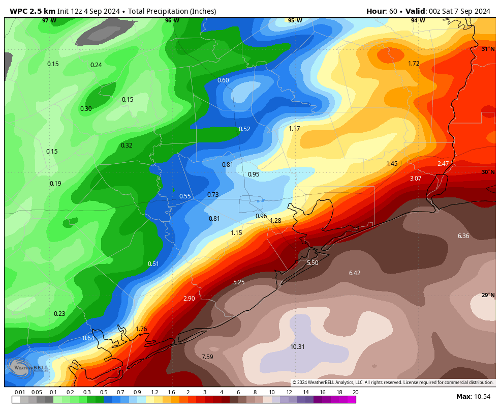
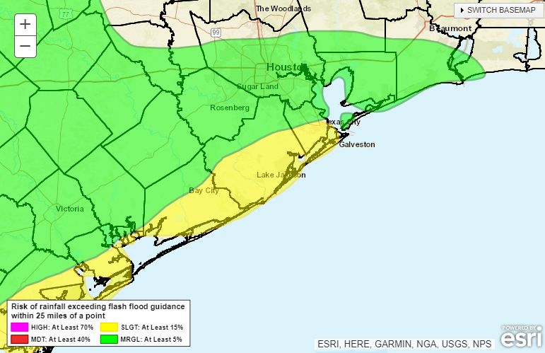
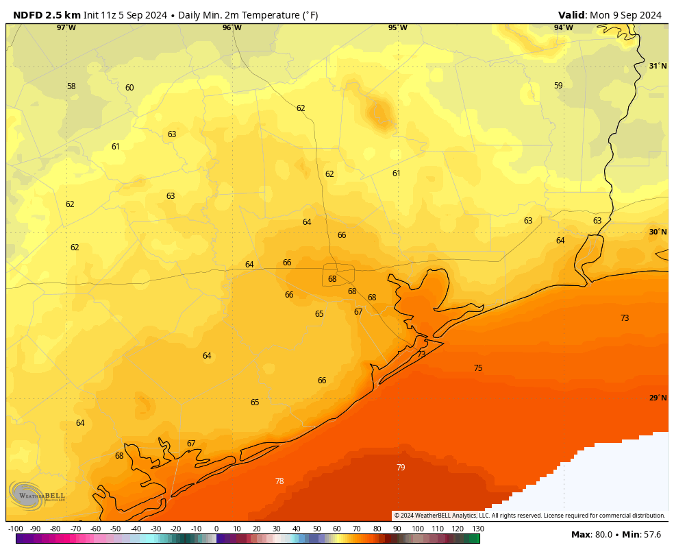
Today and tonight will be the final period of widespread rains, with the potential for coastal flooding. An approaching front will finally begin to nudge a coastal low pressure system away from the upper Texas coast on Friday, and begin reducing rain chances. But first, today. At sunrise the bulk of the showers associated with the low are just offshore. That will begin to change this morning, as some of these rains move inland into coastal areas. The pattern will be similar to yesterday, with widespread showers and thunderstorms likely in coastal counties, and more sporadic showers for inland areas, including most of the city of Houston. For this reason, a Stage 1 flood alert remains in effect for coastal counties, including Galveston.

Map showing areas most at risk for excessive rains on Thursday and Thursday night. (NOAA)

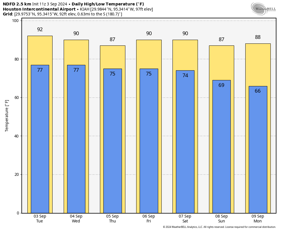
In terms of temperatures, most of the region today will be in the mid- to upper-80s. Winds will be from the northeast, with some gusts up to 20 mph this afternoon, and even higher along the coast. Skies will be mostly cloudy today and tonight, when the potential for showers will linger. Lows drop into the mid- to upper-70s.

Friday

Skies start out mostly cloudy on Friday, and we’ll still see some lingering rain chances throughout the day. However, by the afternoon or evening hours, we should start to see some clearing skies. Highs will likely push into the upper 80s, with gusty northeast winds up to 25 mph.

Saturday

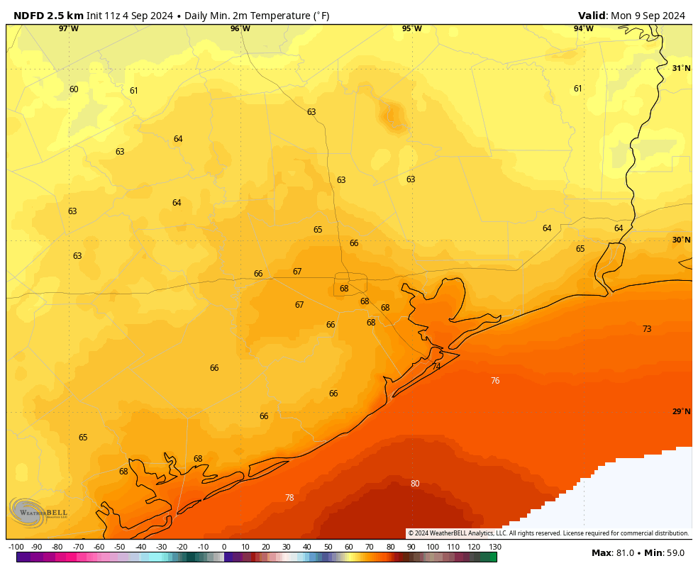
We’ll start to feel the effects of the front, but the drier air will percolate in over time, and it may not be until the afternoon or evening hours when you begin to feel it. With mostly sunny skies, expect high temperatures to reach about 90 degrees. Winds will be noticeable from the northeast, gusting up to 25 mph. Lows on Sunday night will drop into the upper 60s for most locations.

Sunday

This should be a fine day, with highs in the mid-80s, and some of our driest air in months. It still will be a bit breezy, with winds from the north-northeast. Skies will be sunny. Sunday night should be the coolest of the forecast period, with parts of Houston likely to drop into the mid-60s. Now that’s not cold, but combined with the dry air it’s going to feel pretty amazing outside regardless. Enjoy.

Low temperature forecast for Monday morning. (Weather Bell)

Next week

Monday looks to be another day with dry air and cooler temperatures before the onshore flow returns in force by Monday night or Tuesday. This should bring the return of some clouds and healthy rain chances during the Tuesday through Thursday period. Highs should remain in the mid-80s with ample humidity. The end of next week should be a little warmer—we’ll see.

Tropics

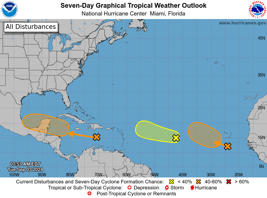
A couple of readers have written in expressing concerns about the tropics. After all, this is the absolute peak of hurricane season for the Texas coast and Gulf of Mexico. But the reality is that the low meandering just offshore—which has been driving our rains in recent days—does not appear particularly likely to develop tropical characteristics (it’s given a 10 percent chance by the National Hurricane Center). Then, we’re watching a tropical wave in the Western Caribbean that may move into the Bay of Campeche early next week.

Tropical outlook for the Atlantic on Thursday morning. (National Hurricane Center)

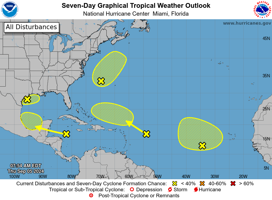
It seems like we’ve been watching this wave forever. And yes, there is some chance (maybe 30 percent?) this begins to develop next week, but most likely it would remain off the Texas coast and eventually be pulled eastward away from the state. So yes, we’ve got things to watch. But there’s nothing I would be too concerned about at this time. If that changes, and of course it could, we’ll let you know.

Coastal rains continue for a few more days, and we’re starting to get excited about this weekend’s cool front

In brief: We will continue to see the potential for showers and thunderstorms in Houston over the next couple of days, but the main threat for heavy rainfall will remain largely confined to the coast. In fact, to account for this threat, we’re reinstated a Stage 1 flood alert for coastal counties through Friday morning. This post also discusses the deliciously dry air on the way this weekend with the season’s first front.

Coastal flooding threat

Instead of slowly fading away, a coastal low pressure system now seems likely to drift back northward toward the upper Texas coast and Louisiana during the second half of this week. Although most of the heaviest rain should fall offshore, coastal counties along the upper Texas coast—Matagorda, Brazoria, Galveston, Chambers and Orange—could pick up an additional 3 to 6 inches of rainfall, with the possibility of higher isolated totals. For this reason we are putting a Stage 1 flood alert back into place for these areas for the time being. This mess should definitively move away by some time on Friday.

NOAA rain accumulation forecast for now through Friday. (Weather Bell)

Early season front

My general rule for cold fronts, in Houston, is that we can generally expect one by the third or fourth week of September. This is not a hard and fast rule. If you recall last summer—the hottest summer on record in Houston—the first front did not arrive until October 7. This year a front will arrive on Saturday, one month earlier. In fact, this front will be our earliest since the year 2017, a year when I guess Mother Nature felt as though she owed us one after Hurricane Harvey.

This front will not barrel into Houston, but drier air should percolate into the area over the weekend, beginning on Saturday and continuing into Sunday and Monday. Some areas, particularly away from the coast, may see dew points dropping into the 40s at times, which is really dry air for this time of year. Lows on Sunday and Monday mornings should drop into the 60s for most of the region and, combined with the drier air, it will feel really pleasant. The first fall fronts never last very long, so enjoy the cooler weather while it lasts.

Wednesday and Thursday

Both today and Thursday will see elevated rain chances due to the presence of the coastal low pressure system. As noted above, rain showers will be hit or miss for inland areas, but there is a decent chance for some street flooding along and near the coast. Highs will range from the mid-80s for coastal areas to about 90 degrees inland, with mostly cloudy skies. Winds will generally be from the east or northeast, at about 10 mph, with gusts up to 20 mph.

Friday

Some additional showers are possible, particularly for coastal areas. However, we’ll also start to see some sunnier skies mix in, especially for inland areas. High temperatures should be in the upper 80s.

Saturday and Sunday

Sunny skies will prevail, with highs near 90 degrees on Saturday, and perhaps the mid-80s on Sunday in the wake of the front. Low temperatures and the extent of dry air will depend on how far you live from the coast, however the entire area should enjoy at least some relief from humidity. This will be a splendid weekend for outdoor activities, although Saturday will be breezy as the front pushes through, with gusts up to 25 mph or so.

Low temperature forecast for Monday morning. (Weather Bell)

Next week

The dry air hangs on through about Monday before we start to see a southerly flow return. Highs will likely return to around 90 degrees, and rain chances are back on the menu beginning Tuesday or Wednesday.

Tropics

There’s a lot to watch in the tropics over the next week or 10 days, but beyond the low pressure system bringing us rain over the next couple of days, it is nothing I’m too particularly concerned about at the moment. The Eyewall will have more later today.

Recapping this weekend’s widespread rains, looking ahead to an early season cool front

In brief: After a wet weekend for many locations, Houston will see continued on-and-off showers for a few more days this week. Skies turn sunnier by the weekend and yes, some sort of cool front really is going to push into the region. It will mean drier air, and at least slightly cooler temperatures. For early September that’s pretty fine weather.

Labor Day Weekend rains

As expected, it was a soggy Labor Day Weekend for coastal areas. Some locations in Galveston Island and Bolivar Peninsula picked up 4 to 6 inches of rainfall on Saturday, Sunday, and Monday after soils were already sodden by last week’s showers. Most inland areas saw considerably less rain over the weekend, although mostly cloudy skies generally kept a lid on high temperatures at about 90 degrees. Healthy rain chances will persist this week, but accumulations should be less for coastal areas. Therefore we are dropping the Stage 1 flood alert that had been in place for those locations.

Estimated rainfall accumulation over the Labor Day weekend. (NOAA)

Tuesday

The flow will become a little more northeasterly today across much of the region, and this will tamp down rain chances with one exception. That is, areas south and west of Houston will have access to somewhat more moisture, and we’re already seeing some coastal showers in places such as Lake Jackson and Matagorda Bay this morning. Rain chances will be fairly high in southern Brazoria and Fort Bend Counties, but only in the 20 to 30 percent range for most of the rest of the area. Highs will generally reach about 90 degrees, under mostly cloudy skies. Overnight lows will drop into the upper 70s.

Wednesday and Thursday

With more moisture available, I expect there to be better rain chances for much of the metro area, perhaps 50 percent or higher each day. Still, accumulations don’t appear to be anything crazy, perhaps a few tenths of an inch for most locations with higher totals possible right along the coast. Highs on these days will range from the upper 80s to about 90 degrees, with mostly cloudy skies.

Friday

Look for a partly sunny day, with lower rain chances. Highs will reach about 90 degrees.

Temperatures will moderate some, but the drier air should be more noticeable this weekend. (Weather Bell)

Saturday and Sunday

The first half of the weekend should be sunny and warm, with highs around 90 degrees. Drier air, in association with a cool front, should arrive sometime on Saturday or Saturday night. By Sunday morning probably, and Sunday evening at the latest, conditions should start to feel notably drier. As to the effect of this front on temperatures, highs on Sunday will probably max out in the upper 80s, with overnight lows in the mid- to upper-60s for most of Houston. The drier air should last through about Tuesday, which is pretty OK for the season’s first front.

Tropical outlook for Tuesday morning. (National Hurricane Center)

Tropics

We’re still keeping an eye on some things, and I think there’s a pretty decent chance that we see some sort of activity in the southern Gulf of Mexico about a week from now. But as for threats to the upper Texas coast, I’m just not seeing too much to be concerned about right now. For early September, that is a great place to be.

Intermittent rains continue, and believe it or not Houston should get its first fall front this weekend

In brief: We sincerely hope everyone is enjoying a bit of relaxation over the Labor Day Weekend in Houston. As meteorologists, of course, when the weather is weather-ing, we’ll be here to cover things regardless. And we will continue to see additional showers and thunderstorms today, particularly south of Interstate 10. Also, it really does appear as though fall’s first front arrives next weekend. Cannot. Wait.

Labor Day

We are seeing the development of widespread showers over southern parts of the Houston region this morning, in locations such as Texas City and Galveston Island. As a low pressure system wobbles offshore, the greatest threat of heavy rainfall now lies primarily to the south of the Houston area (rather than to the east, as it was earlier this weekend). Galveston, Brazoria, and Matagorda counties are at the highest risk of heavy rainfall today and tonight, and so we are maintaining a Stage 1 flood alert in effect for those locations.

This map highlights the areas most at risk for heavy rainfall on Monday. (NOAA)

For the bulk of the Houston metro area, today will bring an ongoing chance of showers and thunderstorms. Most locations have perhaps a 50 percent chance of seeing rain today, which is something to keep in mind if you have Labor Day plans. Otherwise, expect partly to mostly cloudy skies with high temperatures in the upper 80s to about 90 degrees.

Tuesday, Wednesday and Thursday

We’ll continue to see healthy rain chances for these days, but my sense is that the threat of locally heavy rainfall should diminish a bit, even for coastal areas. Sometime later this week, perhaps by Thursday afternoon or evening, we should start to see a clearing pattern. Until then, we can probably expect partly to mostly cloudy days with highs around 90 degrees.

Friday, Saturday, and Sunday

We should see mostly sunny skies for the weekend in Houston, with much diminished rain chances, at 20 percent or less. Friday and Saturday should be fairly warm, with highs in thew low 90s or thereabouts. However, our confidence is increasing in the arrival of a cool front on Sunday or Sunday night. This does appear to be a bonafide cool front, with a decent push of drier air, but since we’re still in early September I want to temper expectations.

There is a lot of ensemble model support for a cool front about six days from now in Houston. (Weather Bell)

After the front’s passage we will see dewpoints fall, and noticeably drier air. High temperatures are still going to reach the upper 80s, with mostly sunny skies. But mornings, evenings, and nights should feel pleasant through about Tuesday or so. Inland locations will probably see nighttime temperatures in the 60s on Sunday and Monday night. This would be a couple of weeks earlier than normal for Houston’s first real fall front, so it is definitely something to savor.

Tropics

There’s activity out there, but not a whole lot I would be particularly concerned about at this time. Stay tuned to The Eyewall for in-depth updates.