Colder weather arrives on Sunday, with the possibility of snow early next week

In brief: Today’s post delves into the uncertainty around the potential for snow early next week, as well as just how cold things will get. The reality is, in Houston, one just cannot confidently forecast snow nearly a week out. As for temperatures, we appear to be trending away from extreme cold, which is a good thing.

Winter storm real talk

Whenever there’s the possibility of snow in Houston, people lose their minds. Some people are absolutely giddy at the rare prospect of snow. Others fear what it will do to Houston’s unprepared drivers and untreated roads. Kids anticipate the rarest of all gifts in Houston, a ‘snow’ day.

Here’s the reality from a forecaster’s standpoint. Yes, there is an increasing possibility of snow or sleet beginning next Monday night and Tuesday, but this is still nearly six days away. This means our confidence in forecasting any wintry precipitation remains very low. There is probably about a 50-50 chance we see some kind of wintry mix, so set your expectations accordingly. Our confidence in the forecast will increase as we get closer.

How different types of winter precipitation form. (National Weather Service)

Wednesday

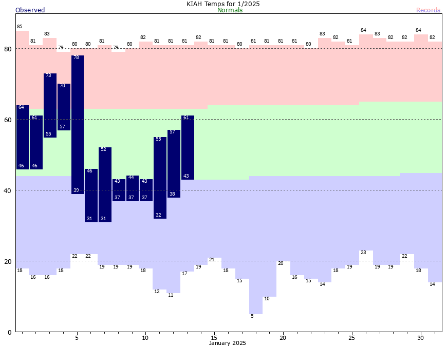
We’re seeing fairly widespread, light showers this morning, and these will continue for most of the day. The showers are more numerous south of Interstate 10, closer to the source of moisture. None of this rain is likely to turn heavy, so mostly the will just be a cold, light rain. With mostly cloudy skies, expect high temperatures in the low 50s. Temperatures tonight will drop to about 40 degrees, with clearing skies.

Thursday

NICE DAY ALERT! This will be a mostly sunny day day with high temperatures in the low 60s. Honestly, looking ahead at the forecast, this is probably going to be the nicest day outside for quite awhile. Lows on Thursday night will drop into the lower 60s.

Friday

We’ll see some blue skies on Friday morning, maybe, but then clouds will start top build. Temperatures will approach 70 degrees during the afternoon hours, with modestly increasing humidity levels. There will be a slight chance of some showers on Friday night, but these now look to be mostly light instead of anything threatening. Lows on Friday night will likely only drop into the upper 50s.

Saturday

This will be a partly sunny day, with highs in the low 60s ahead of a strong cold front. A few showers and thunderstorms may be possible just ahead of the front as it moves through, but for many people this could be a dry passage. I expect the front to reach central Houston by around noon, and push off the coast shortly afterward. We may hold on to temperatures in the 50s for a few hours after the front passes, but as the sun sets and northwesterly winds blow, much drier and colder air will be pushing in. Lows on Saturday night will drop into the 30s.

Current forecast for start-line temperatures at the marathon on Sunday morning. (Weather Bell)

Sunday

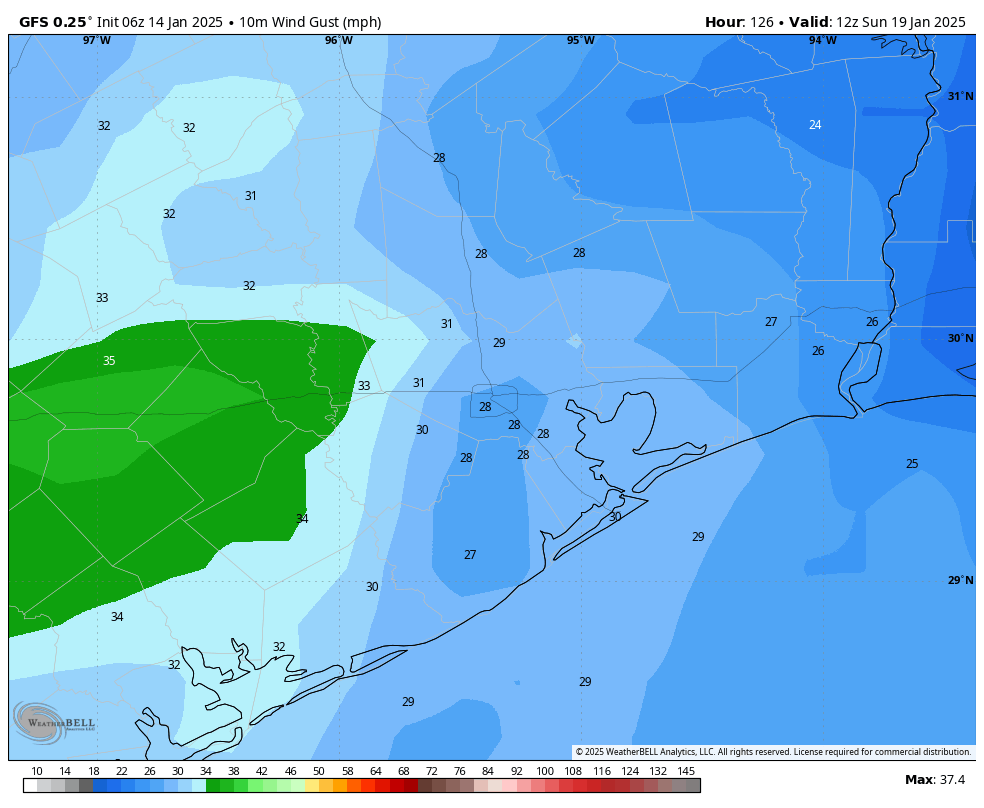
You read that right, marathon runners. I now expect start-line temperatures in Houston to be in the vicinity of the mid-30s. We don’t need to worry about precipitation, fortunately, and skies should be mostly clear. What I’m watching mostly closely is winds. Right now they’re likely to be out of the north at 10 to 15 mph. The trend in gusts has been slightly lower, so for now I’d anticipate gusting up to about 25 mph. That is certainly no picnic, but it beats 30 or 35 mph. The bottom line is that if you’re running, I recommend bundling up. I’ll be wearing my warmer gloves for this one. Highs on Sunday will reach the mid- to upper-40s most likely before a possible freeze on Sunday night.

MLK Day

The forecast models have, in recent runs, backed off some of the extreme cold anticipated for next week. The caveat at the beginning of this post about snow uncertainty still applies to temperatures as well. But at this point I would expect most of Houston to experience a light freeze on Monday morning, with partly sunny skies. Highs will only reach 40 degrees. So if you’re participating or watching a parade, please dress warmly.

The rest of next week

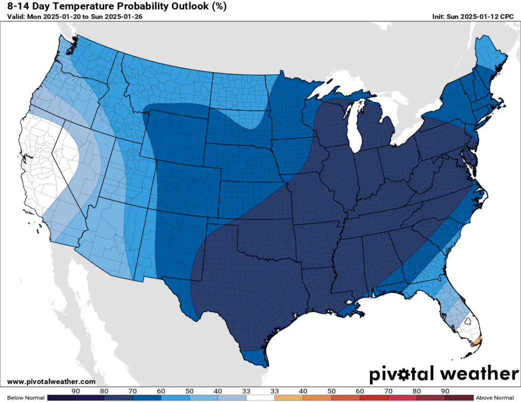
Beginning Monday evening, through Wednesday morning, is when the Houston region will experience the best chance of a wintry mix and coldest temperatures.

The European model ensemble forecast is fairly bullish on snow next Tuesday in Houston, but such forecasts can (and often do) change. (Weather Bell)

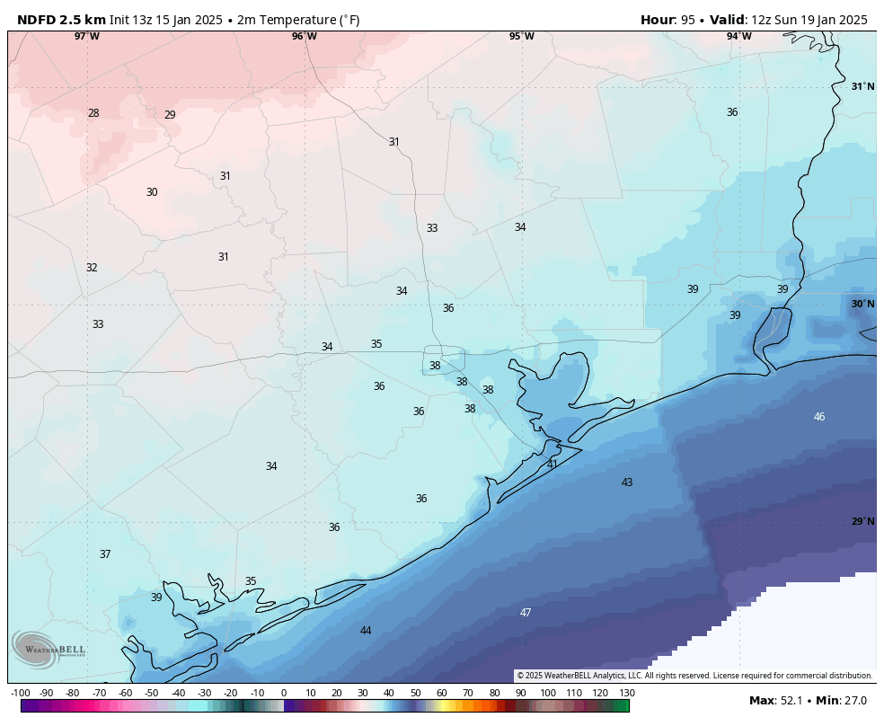
We’ll start with temperatures. At this point I think we’ll probably bottom out on Tuesday and Wednesday mornings. For Houston, the likely range of temperatures on these mornings is probably 25 to 30 degrees, with a hard freeze possible for inland areas, and the immediate coast possibly remaining just above freezing. High temperatures through Wednesday will likely be on the order of 40 degrees. Again we’ll have to fine-tune the temperature forecast as we get closer.

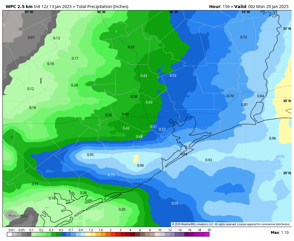
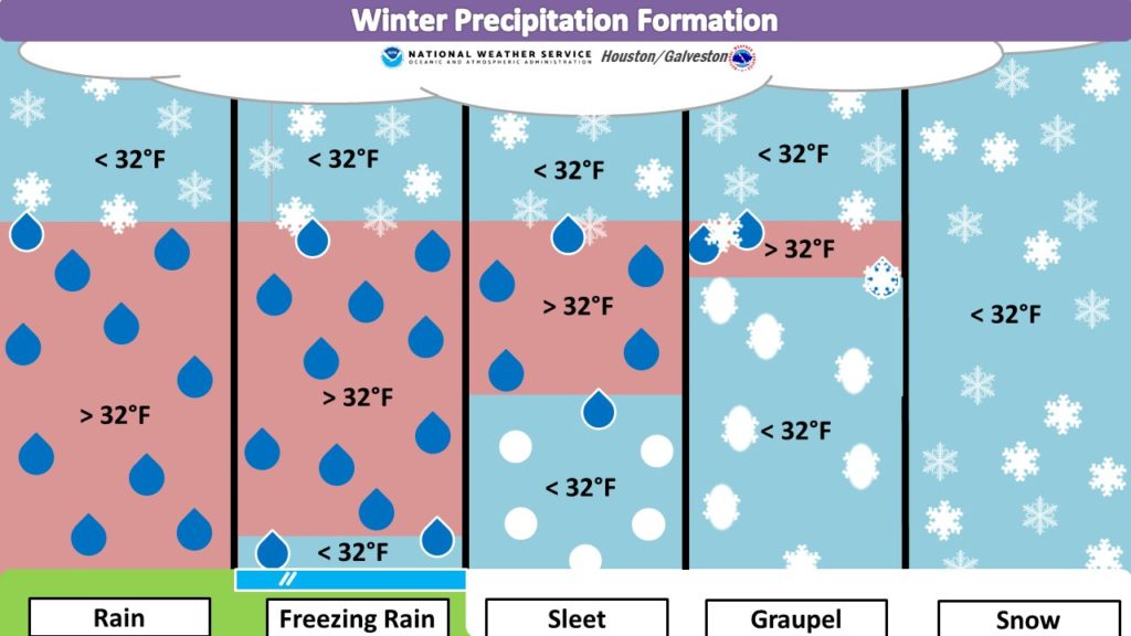
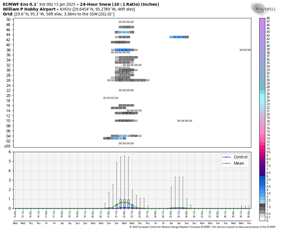
With regard to precipitation, we’ll start to see an influx of moisture beginning later on Monday and Monday night, and this will bring a modest chance of precipitation on Monday night, Tuesday, and Tuesday night. With the colder air this brings the possibility of snow (most likely at this time), sleet, or freezing rain into the forecast. Because slight temperature differences in the atmosphere will determine the type of precipitation, we just cannot make a call on whether it will snow, sleet, or rain in Houston during the first half of next week. But it’s a distinct possibility, along with some mobility issues on Tuesday and Wednesday morning. We’ll be watching all of this closely over the weekend for you, with regular updates.

A warming trend begins Thursday.

How Space City Weather will, and will not, use artificial intelligence

In brief: The initial release of ChatGPT in November 2022 sparked a widespread recognition of the promise and peril of artificial intelligence. We’ve been watching these developments closely, both in the broader public context as well as in weather modeling. For the sake of transparency, here’s how we plan to use AI now and in the future.

As artificial intelligence plays an increasingly prominent role in society, I want to clarify what this means for Space City Weather now, and in the future. The central message I wish to convey is that Space City is, and always will be the creative product of human beings. What is written and forecast here is done by people. At the same time, Matt and I are not burying our heads in the sand. As technology changes, we embrace that which improves our ability to forecast the weather and communicate that information.

For example, I started in newspaper journalism more than 25 years ago. At the beginning of my career, printed newspapers still largely set the news agenda. But in 2005, while still at the Houston Chronicle, I started blogging. With the arrival of hurricanes Katrina and Rita that summer, I soon realized the power of immediate communication on the Internet, the value of sharing links to credible information, and the hunger of people for this change. In the two decades since, I have made the majority of my living writing for online publications, without a paywall. This is one reason why I am so committed to keeping Space City Weather free and open to all. We started as a web site, grew on social media, and now many of you are reading this on an app. I cannot foresee where things will be in 10 years, but wherever people want to read Space City Weather, we will be there.

The rise of AI and weather

Artificial intelligence has been lumbering along in the background for several years, but it has really broken through recently with large language models such as ChatGPT. These artificial intelligence systems can be quite good at some tasks. One of these turns out to be forecasting the weather. There are repositories of meteorological data that go back more than 50 years that can be used to ‘train’ designated models for weather prediction. There are now about 10 major groups out there developing AI-based models, and some of them have gotten quite good. Further improvements are likely.

Traditional weather models, which are based on complex physical equations, attempt to simulate the atmosphere and crunch through those equations to predict what will happen next. These physics-based models have gotten steadily better over the years, especially because of more powerful supercomputers and sophisticated tools to ingest more real-world weather conditions (i.e. the temperature at 10,000 feet above the surface of the Atlantic Ocean) into the model before it is run. AI-based models perform none of these physical computations. They can, therefore, be run incredibly quickly, on fairly simple computers.

How we will use AI

Matt and I have been following the output of AI-based weather models for more than a year now, and they definitely have their strengths. Such models are quite good at three- and five-day forecasts to the point where they sometimes outperform physics-based models at tasks such as hurricane tracks. They also have their weaknesses. For example, AI-based models are not (yet) good at high-resolution modeling and predicting the development of thunderstorms. So no, we still won’t be able to tell you whether it’s going to rain at your house at 3 pm on some days.

The bottom line is that we are using AI-based modeling tools as a part of our forecasts here at Space City Weather. They’re not a panacea, but they are another tool in our arsenal that runs the gamut from hand-drawn isobar maps to sophisticated models on supercomputers. I suspect they will be an even more useful tool over the next five years. But that is where our use of artificial intelligence will end. We have not, nor will we use any AI-based service for the writing of our forecasts. Very occasionally we may use an AI-based illustration, but if we do it will be clearly labeled as such.

We want you to know that at Space City Weather our commitment is to show up every day and make each forecast with our best effort, without influence or intervention from anyone else. We don’t win them all. Humans are fallible. But you can rest assured that they are honest mistakes rather than AI-induced hallucinations.

— Eric Berger, January 2025

Next week’s Arctic blast starting to come into better focus, and it looks fairly cold

In brief: In today’s post we discuss the state of Houston’s winter to date, which is more or less in line with seasonal predictions. We then look at relatively mild weather for the rest of this week, followed by sharply colder conditions on Sunday and the first half of next week.

Winter update

Don’t look know, but if we define winter as December, January, and February—which is as good a time period for winter in Houston as any—we are now just about halfway through. So far, we have had generally warmer than normal temperatures, with the city’s average temperature in December nearly 6 degrees above normal. Last week was significantly colder, but on average we’re still a few degrees above normal so far this winter.

What is “normal?” Generally, in January, we see highs in the low 60s, and overnight lows in the lower 40s. We will be in the vicinity of that for most of this week, although the mercury goes up toward the end of the work week. We might even hit 70 degrees on Friday or possibly Saturday ahead of a strong front.

Houston experienced its first bout with much colder winter weather last week. (National Weather Service)

If you cast your mind back two months ago, when we published our winter outlook, we predicted a warmer than normal winter. But there was a caveat:

Because of the way this pattern sets up, it will block much of the colder Arctic and Canadian air from the lower United States for most of the winter. But that does not exclude the pattern breaking one or two times. If that happens, and it probably will at least once this winter, there will be a large pool of much colder air available to dip down into the southern United States, including Texas.

We had the first of those outbreaks of colder Arctic air during the first 10 days of January. Now, we’re about to get a second one during the last 10 days of the month. At this point, the upcoming period of colder weather looks like it could be sharper than the first one in early January, with a hard freeze possible for much of the Houston metro area. More on this below.

Tuesday

Winds have shifted to come from the northeast overnight, and they’ll shift further to the east today. This will bring with it an increase in atmospheric moisture and the development of more clouds. This will help to limit high temperatures to the mid- to upper-50s today with milder conditions tonight. Lows will drop into the upper 40s.

Wednesday

This will be a fairly grim day. In addition to mostly cloudy skies, a coastal low will help produce a decent chance of rain showers across the southern half of the metro area, with a lower possibility of rain further inland. Expect highs in the lower 50s, so along with leaden skies and the potential for some light showers this will be dreary affair. Lows on Wednesday night drop into the low- to mid-40s.

Thursday

This day should bring some sunnier skies, with highs of around 60 degrees and overnight lows in the mid-40s.

High temperature forecast for Friday.

Friday

This will be a warmer day, with highs near 70 degrees and partly sunny skies. However, there will be chance of showers later in the day, and possibly a few thunderstorms out ahead of a cold front that’s due to push through on Saturday. Lows on Friday night will only drop into the upper 50s, which will be our warmest night for quite a while.

Saturday

The cold front is on schedule to arrive on Saturday, perhaps sometime around the middle of the day. We’ll be reasonably warm ahead of the front, and it looks like colder air will lag a bit behind the frontal passage. So with partly to mostly sunny skies, we could see some highs in the upper 60s. However as evening rolls around the northerly winds will start to really ramp up, ushering in colder and drier air. Look for overnight lows to fall to around 40 degrees in Houston, or a bit lower.

GFS model forecast for wind gusts at 6 am CT on Sunday morning. (Weather Bell)

Sunday

If you’re going to be on the start line of the Houston Marathon on Sunday morning like me, you’re going to want to prepare for colder temperatures. The good news is that I don’t expect any precipitation, and skies most likely will be partly to mostly sunny. The bad news is that winds will bring an additional chill into the air. I expect sunrise temperatures to be in the upper 30s in downtown Houston, with the likelihood of wind gusts of 20 to 30 mph. So it will feel really cold, especially in downtown with the tunneling effect between buildings. Even for people who like to run in cold weather, like me, this is pretty chilly. Highs will reach about 50 degrees later on Sunday before temperatures plunge on Sunday night.

Next week

So how cold will things get next week? We just cannot say for certain yet. I think we are probably looking at lows in metro Houston anywhere from the low-20s at the low end, to low-30s at the higher end of the forecast. So that’s the possible range. The coldest days look to be Monday, Tuesday, and Wednesday before temperatures moderate toward the end of the week.

As for precipitation, there’s a non-zero chance of snow or sleet on Monday, Monday night, or Tuesday. I do think snow is at least a possibility, because the atmosphere looks to be freezing all the way down to the ground. But it will depend on whether we get any precipitation, and how much, and at what hours of the day or night. I think the bottom line is that we might expect the possibility of some travel disruptions on Monday or Tuesday of next week, but that does not mean serious issues are likely. We’re just going to have to see how the forecast plays out over the next couple of days. Matt and I will be watching things closely for you.

A mild week ahead, followed by a likely return of freezing temperatures early next week

In brief: Houston will see a warming trend this week, with high temperatures eventually pushing near 70 degrees by Friday or so. We’ll also see plenty of clouds later this week, along with some modest rain chances from Wednesday onward. A strong front arrives on Saturday, and this will usher in a period of significantly colder weather next week.

Early post

Surprise! As I write this it is 5:15 am ET in the Orlando airport, and I am awaiting an early morning flight back to Houston. I’ve been up all night so this post will be fairly brief, but I wanted to dash it off before I pass out. It was an eventful night, with the debut launch of Blue Origin’s New Glenn rocket scrubbed during the final hour of a three-hour launch window. Alas.

Monday

After a chilly start this morning, we should see clearing skies and high temperatures in the mid- to upper-50s. Winds will be brisk, from the north, for much of the day adding an extra bit of chill. Lows tonight will fall to around 40 degrees in Houston. This is likely to be our coldest weather until next Sunday morning.

Tuesday

As winds shift to come from the northeast, we’ll see some more clouds in the sky, and this should limit high temperatures to the mid-50s. Lows on Tuesday night will only drop into the mid-40s as increased cloud cover provides a bit of insulation.

NOAA rain accumulation forecast for now through the weekend. (Weather Bell)

Wednesday and Thursday

As high pressure moves east we’ll see the southern portion of the Houston region become susceptible to a bit of rain. Don’t expect anything serious, but some areas south of Interstate 10 could pick up perhaps half an inch of rain, or a little more, during this period. Chances for inland areas are lower, perhaps just 10 or 20 percent each day. With partly to mostly cloudy skies, expect highs in the mid- to upper-50s. Lows will be milder, in the upper 40s mostly.

Friday

This will be a warmer day, with partly sunny skies and highs of about 70 degrees. Break out the shorts! However there will also be a decent chance of rain (again, mostly light) so this may not be a spectacular day all around. Lows on Friday night will only drop into the upper 50s.

Saturday

This will be another mild day, with highs near 70 degrees and partly sunny skies. At some point on Saturday, perhaps around noon, afternoon, or the evening, a cold front will push into the Houston area. This may bring an additional shot of rain, followed by stronger northerly winds that will really dry us out.

Sunday

The forecast for Sunday, and the Houston Marathon, is continuing to come into better focus. Low temperatures on Sunday morning are likely to be in the upper 30s or lower 40s, but it will feel colder with what is expected to be a fairly stiff northerly breeze. While there’s still the potential for some change, my advice is to prepare to bundle up. Skies should be clearing so I don’t anticipate precipitation being an issue. High temperatures may reach the upper 40s or 50 degrees before another cold night.

Something cold this way comes. (Pivotal Weather)

Next week

There are no bones about it, next week looks pretty cold. I do think we’re likely to see freezing conditions in the Houston metro area on at least one or two nights, but it remains to be seen whether we see a hard freeze (defined as 28 degrees F or below by the National Weather Service) in Houston. Several people have asked about the potential for snow, or a wintry mix next week. I do think it’s possible on Monday or Tuesday nights, but we just have to see how cold temperatures get, and whether we see any precipitation during these colder times. It’s something we’ll continue to keep an eye on, but it will be a few days at least before we have any definitive answers.