In brief: Houston’s high temperature hit 101 degrees Wednesday with modestly drier air. Now, as tropical moisture moves into the region we will see increasing rain chances heading into the weekend. And looking ahead to August, the start of the month appears to be fairly mild as August goes in these parts.
At least it’s a dry heat
Houston’s high temperature reached 101 degrees on Wednesday at Bush Intercontinental Airport. This was aided in part by high pressure, but also unusually dry air. During the mid- to late-morning hours in the city, the dewpoint fell into the 50s, which made the heat feel a little (emphasis on a little) more tolerable. Anyway, drier air warms more efficiently than air with higher levels of moisture, so that helped turn a hot day into a sizzling one. Moisture has already begun to increase in the atmosphere, so that will set the stage for slightly cooler, but more humid weather with rising rain chances as we get closer to the weekend.
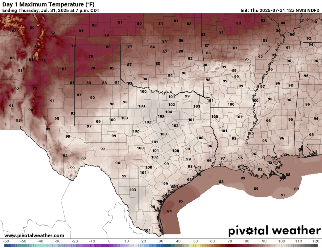
Much of Texas will hit 100 degrees again Thursday, but the Houston region should remain in the upper 90s. (Pivotal Weather)
Thursday
Speaking of rain chances, showers have developed this morning on the eastern side of Galveston Bay, in places such as Anahuac and Bolivar Peninsula. I expect these storms to hang together and move into the southern half of the region (generally south of I-10) later this morning. Additional light to moderate showers will be possible later today, but overall chances are probably only about 30 percent. An increase in clouds and atmospheric moisture levels should hold high temperatures in the upper 90s for most locations today.
Friday
This will be another day with partly to mostly sunny skies, and high temperatures in the mid- to upper-90s for most locations. There will be scattered showers throughout the day, and an increasing risk of some stronger showers Friday afternoon or evening. Again I think these will be fairly scattered in nature, but we cannot rule out a few thunderstorms if you are out an about on a Friday night. Overnight temperatures, otherwise, remain warm and muggy.
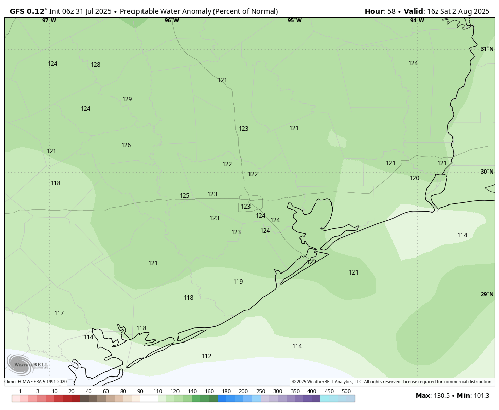
Levels of atmospheric moisture, or precipitable water, will be above normal on Saturday, indication background conditions more fertile for rain. (Weather Bell)
Saturday and Sunday
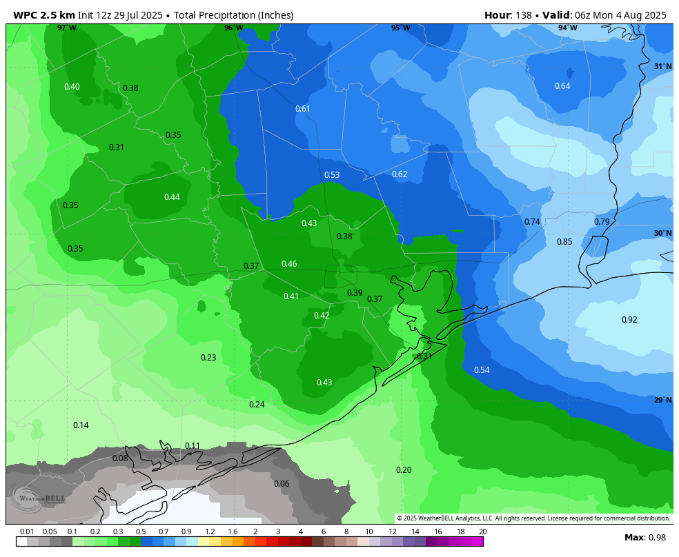
Even though skies should remain partly to mostly sunny this weekend, we will see our best rain chances on Saturday and Sunday. Most of the area should see intermittent light to moderate showers on Saturday, and Sunday will also likely see half the region recording some precipitation. Overall accumulations look fairly modest, in the 0.25 to 0.5 inch range for most, but there may well be some bullseyes with 2-plus inches of rainfall. So while it is unlikely, we cannot entirely rule out some isolated street flooding. Highs look to be in the low- to mid-90s on both days.
Next week
All in all, for August, next week looks to be fairly typical. We can expect high temperatures generally in the low- to mid-90s, with mostly sunny days. However there will also be a daily chance of showers (nothing crazy, mind you) that will likely be driven by the sea breeze. Any days we can get through August without blistering heat or a threatening tropical system are small victories.
Tropics
Speaking of the tropics, there’s just not much happening out there at the end of July. Sure, there are a couple of tropical waves we are keeping an eye on, but nothing that appears likely to develop for at least the next week. So, dare I say, I feel pretty good about Houston’s weather heading into August? I can’t remember the last time I felt or said that.
In brief: Houston will see one more very hot and sunny day before rain chances return to the forecast. The best odds for rain come this weekend, but even then we don’t anticipate a total washout. Highs remain in the 90s throughout the forecast period, as is typical for this time of year.
Overall pattern
High pressure will hold sway for another day or two before giving way to increasing moisture levels from the Gulf. With the ridge breaking down, the Houston region will be more open to showers this weekend, although we don’t anticipate anything too calamitous. As we get later into August next week, a fairly typical pattern will set in whereby high pressure influences our weather, but there is still the possibility for some afternoon showers and thunderstorms due to the sea breeze.
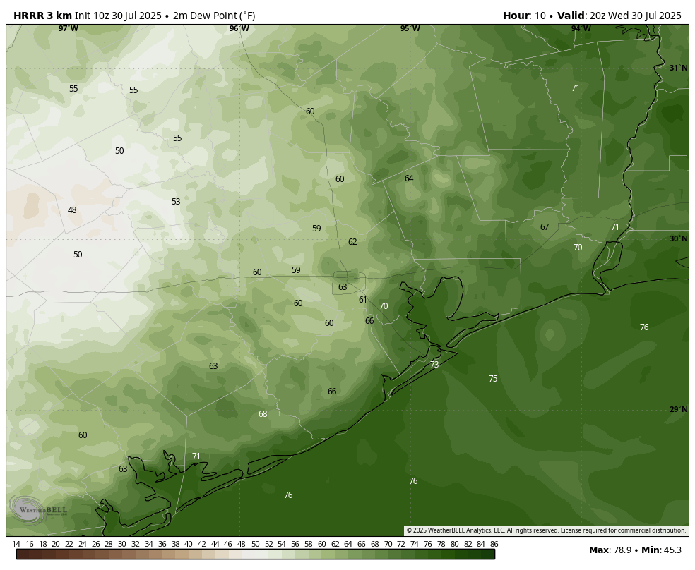
HRRR model forecast for dewpoints at 3 pm CT on Wednesday. (Weather Bell)
Wednesday
The high temperature at Bush Intercontinental Airport hit 99 degrees on Tuesday, and we are likely to do the same today, and possibly push into triple digits across some parts of the area. A surge in air temperatures today will be supported by the influx of somewhat drier air from the west. It’s not clear how far this drier air will push into Houston, but we could see some rare dewpoints in the upper 50s today along and west of Interstate 45. It’s still going to be quite hot, but for areas away from the coast it should feel a little less humid. Skies will be sunny, with light westerly winds. Lows tonight will drop to around 80 degrees.
Thursday and Friday
The last two days of the work week will see more moisture streaming in from the Gulf, and this will start to elevate rain chances a bit, perhaps to 30 percent each day. Don’t get me wrong, these will be mostly sunny days, and any showers that develop will likely pass quickly. But the increased moisture should help to limit high temperatures to the upper 90s for most of the region.
Saturday and Sunday
The weekend will bring the highest chance of rain, likely around 50 percent for both days. The odds and accumulations of rain are likely to be higher the closer to the coast you are. For most of us, I expect rain totals in the 0.25 to 0.5 inch range. However, given the tropical nature of this rainfall we cannot rule out some stronger, isolated downpours that briefly flood low-lying streets. Both of these days should still bring partly sunny skies. Highs will depend on the extent of rain and cloud cover during the afternoon hours, but probably will be in the vicinity of the mid-90s with plenty of humidity.
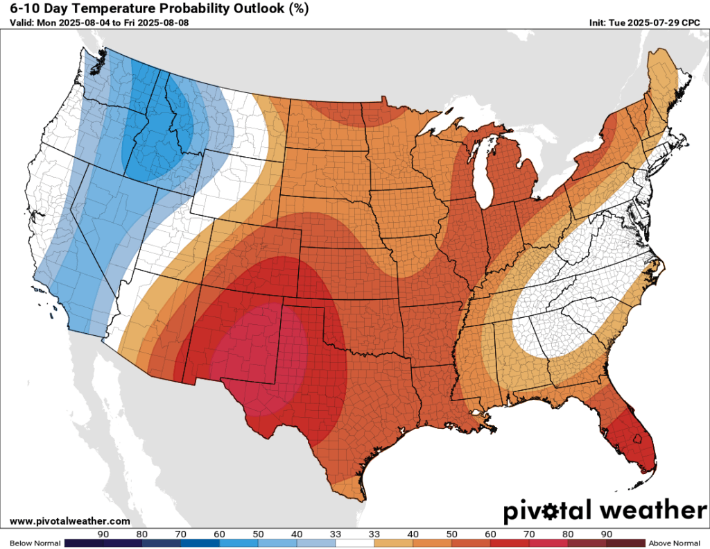
Temperatures next week look warm in Houston, but the greater heat should be anchored over West Texas. (Pivotal Weather)
Next week
The first full week of August will likely bring mostly sunny skies and highs in the mid- to upper-90s. Expect some isolated to scattered shower chances daily, but at this point it’s difficult to say more than this. Basically, August will do August things. Which in Houston means pain.
Editor’s note: On July 29, 2025, we published a new version of the Space City Weather Flood Scale. The new version incorporates research done by two psychologists at the University of Houston, Steven Paul Woods, Psy.D. and Natalie C. Ridgely, Ph.D. We intend the new version to be more user friendly and helpful in the time of a storm. In this post, Drs. Woods and Ridgely explain the research they did to inform this update. And here’s a link to the official news release from the University of Houston.
How can we help Houstonians better prepare for major weather events?
An impassioned tweet from Matt about the challenges of weather communication during the 2022 hurricane season led us to wonder: Can we use psychological science to help Houstonians better understand and prepare for major weather events? We posed this question to Matt, who was enthusiastic about the potential of a meteorology-meets-psychology research collaboration. Matt and Eric were specifically curious if we could boost the usefulness of the beloved Space City Weather (SCW) Flood Scale (Lanza & Berger, 2023).
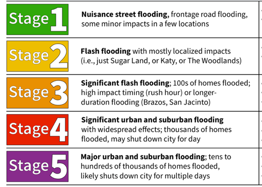
The original goal of the SCW Flood Scale was to help Houstonians better understand and prepare for a wide range of flooding events. The SCW Flood Scale uses a color-coded numerical rating system (1 green = nuisance street flooding to 5 red = severe life-threatening flooding) and provides a historical flooding event for context (e.g., Hurricane Harvey). But does it nudge people to actually prepare for flooding? This is important because even when people know the flooding risk of an approaching storm, they may not turn that knowledge into useful ways to protect themselves (i.e., weather-protective behaviors). There are meaningful gaps between what we know, what we intend to do, and what we actually do (e.g., Fishbein, 1979). Providing people with direct informational cues can help bridge these gaps (Grounds & Joslyn, 2018; Woods et al., 2022). So, we designed a simple experiment to see whether including examples of appropriate weather-protective behaviors at each level of the SCW Flood Scale helps people do a better job of planning for storms.
How did we do this study?
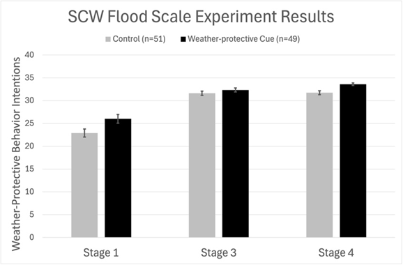
The Storm Forecasts: With Matt and Eric’s help, we created three realistic storm forecasts that varied in severity on the SCW Flood Scale (i.e., Stages 1, 3, and 4). We presented these storm forecasts to people in a randomized order.
The Weather-Protective Behaviors: After hearing the three storm forecasts, participants were asked to rate their intentions to do 12 different weather-protective behaviors on a scale of 1 (unlikely) to 5 (very likely). Higher scores mean stronger plans to practice useful weather-protective behaviors. We included actions that would be helpful in a flood, like reducing the amount of time spent on the roads, gathering necessary supplies, charging electronic devices, and listening for emergency alerts. We also included actions that sounded reasonable, but may not be helpful during a flooding event, like wrapping exposed pipes, securing the foundation of their home, or sheltering in a basement.
The Experimental Groups: The study participants were randomized into one of two groups: 1) A control group who saw the standard version of the SCW Flood Scale; or 2) A weather-protective cue group who saw a new version of SCW Flood Scale that included examples of weather-protective behaviors at each level of flood risk (e.g., Stage 1 = Consider reducing time on the roads; Stage 3 = fuel vehicles; Stage 5 = identify safe evacuation routes).
The Study Participants: We recruited 100 healthy adults from 5 Gulf Coast states to participate in this study. Importantly, the control group and the weather-protective cue group did not differ in demographic factors (e.g., age, education), cognitive ability, weather literacy, and experience with storms.
Did the experiment work?
In brief, yes! People in the weather-protective cue group did a better job of planning for the storms. Figure 1 shows the flood-protective behaviors on the vertical axis, where higher scores mean better plans to practice useful flood-protective behaviors. The individual storm forecasts are on the horizontal axis. You can see that the benefits of the protective cues varied by storm severity. The flood-protective cues had strong benefits for the most (Stage 4) and least (Stage 1) severe storms, but only weak benefits for the Stage 3 storm, which was a fast-moving wind event for which flood protective recommendations may be somewhat less clear. Encouragingly, we also found the largest benefits of the flood-protective cues among people who had the lowest levels of baseline weather preparedness. That means we were able to improve flood-protective plans for the people who were at greatest risk of being unprepared. Finally, we found that the flood-protective cues had no effects on non-beneficial actions (e.g., wrapping household pipes). In other words, the flood-protective cues only nudged people towards doing things that are known to be helpful for their health and property during a flooding event.
What’s next?
The results of this simple experiment suggest that adding flood-protective action cues to the SCW Flood Scale increases the likelihood that people will plan to safeguard their home and health in response to flood forecasts. We are excited that Matt and Eric will be working with Reliant to add the flood-protective cues to the SCW Flood Scale moving forward. And we hope that this new version of the SCW Flood Scale will provide additional support and comfort to Houstonians as they prepare for future storms. We are currently looking at whether the benefits of the flood-protective cues vary across people who may be particularly vulnerable to weather impacts, including older people and those with serious medical conditions. We are also curious to learn more about what leads people to choose non-beneficial weather-protective actions in these situations. Finally, we would like to know whether we can help Houstonians better understand and use heat warnings. So, stay tuned for more meteorology-meets-psychological science!
Steven Paul Woods, Psy.D. and Natalie C. Ridgely, Ph.D. Department of Psychology, University of Houston
References
Fishbein, M. (1979). A theory of reasoned action: some applications and implications. Nebraska Symposium on Motivation, 27, 65–116.
Grounds, M. A., & Joslyn, S. L. (2018). Communicating weather forecast uncertainty: Do individual differences matter? Journal of Experimental Psychology: Applied, 24, 18–33. https://doi.org/10.1037/xap0000165
Lanza, M.R. & Berger, E. (2023). The Space City Weather Flood Scale: An imperfect attempt to help a flood-weary region put rain forecasts in context [abstract]. Paper presented at the 103rd Annual AMS Meeting, Denver, Colorado, USA.
Woods, S. P., Morgan, E. E., Loft, S., Matchanova, A., Verduzco, M., & Cushman, C. (2021). Enhancing cue salience improves aspects of naturalistic time-based prospective memory in older adults with HIV disease. Neuropsychology, 35, 111–122. https://doi.org/10.1037/neu0000644
In brief: In today’s post we reveal the new design and content for our flood scale. We have made changes based on research conducted by the University of Houston. Although rain chances will increase later this week, we also anticipate no need to use the new flood scale any time soon.
Updated flood scale
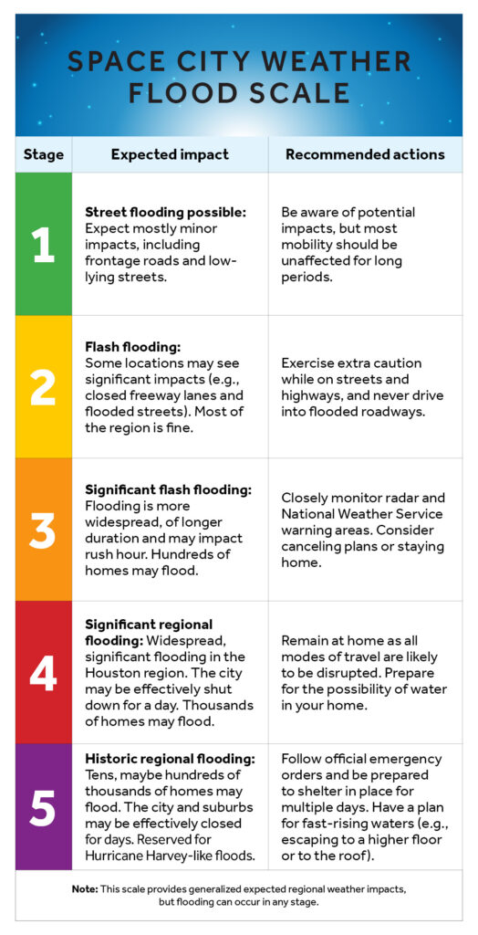
This morning we are pleased to announce an update of our flood scale, which is intended to help guide expectations for people in the greater Houston region when it comes to the potential for flooding. We first introduced our flood scale in 2019, after Hurricane Harvey, and have used it dozens of times since then. But we really did not understand how people were using it.
Now, with the help of some researchers from the University of Houston, we do. A professor of Psychology, Steven Paul Woods, reached out to Matt a couple of years ago, and together they and one of his doctoral students, Natalie C. Ridgely, worked to perform a study of the scale and whether it was effective at communicating risk. Later this morning we will publish a summary of the study, and its results, written by Woods and Ridgely. (Here it is).
As a result of this study, we have made some changes in the structure of the scale to simplify it, and added recommended actions. Reliant provided a cleaner design. What thrills me the most is that this scale was created here in Houston, and improved by local researchers who care about this community just as much as we do. It is by Houston, for Houston.
Our new scale appears below:
Tuesday
Well, we won’t need the flood scale today. With high pressure firmly in place, Houston is going to have one of its hottest days of the year. With sunny skies, look for high temperatures to push into the upper 90s across most of the region away from the immediate coast. Some inland areas may reach 100 degrees. Winds will be very light, from the west mostly. Lows tonight will only drop into the upper 70s.
Wednesday
This will be another hot and mostly sunny day, with highs in the upper 90s. However there will be a couple of subtle differences. One is that dewpoints may drop into the mid-60s across the region. This is not “dry” in any great sense, but these dewpoints are lower than normal for this time of year. So humidity will be lower than we have been often experiencing this summer, especially for inland areas. There also will be a very slight chance of showers later on Wednesday afternoon or evening.
Thursday and Friday
Low pressure stretching across the Gulf will bring increased rain chances into the area for several days. On Thursday and Friday the likelihood of rain will be somewhere between 30 and 50 percent, with low-end accumulations for most. Depending on the timing of rain (if any) highs will vary between the low- and upper-90s, with partly to mostly sunny skies.
Saturday and Sunday
Better rain chances will arrive this weekend, with both days bringing about a 50 percent likelihood of showers. For now we don’t see too much of a risk for really heavy rainfall, and my expectation is that most locations will pick up between 0.25 and 0.5 inch of rain. Since this is summer and tropical rainfall is possible, we’ll be on the lookout for higher totals, but for now this looks more like a splash of rain rather than a deluge. Highs will generally be in the low- to mid-90s with partly sunny skies.
NOAA rain accumulation forecast for now through Sunday. (Weather Bell)
Next week
The first full week of August does not look to be excessively hot. Temperatures probably will be in the mid-90s for the most part, with a smattering of daily showers driven by the sea breeze. Beyond that, we shall have to see.