Houston will continue to see very warm conditions for early March

In brief: In today’s post we talk about our anomalously warm start to March weather, and look ahead to increased rain chances this weekend. Unfortunately, there are still some details to iron out there.

By this weekend our low temperatures should be about 20 degrees above normal. (Weather Bell)

March (temperature) madness

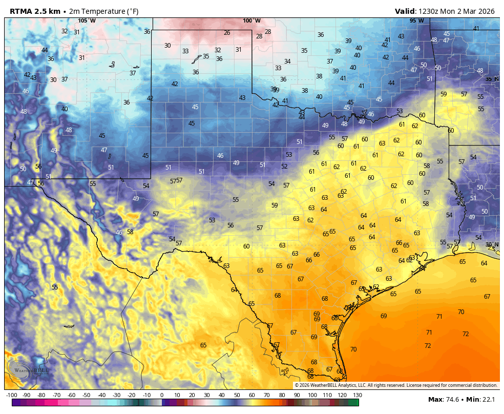
Generally, March is my favorite month of the year weather-wise in Houston. Our temperatures are not too hot, and not too cold. During the first part of the month the average high is typically around 70 degrees, and the average low is is 50 degrees. We usually have not yet reached the spring storm season. However this March is starting out quite a bit warmer than usual. And for the next 7 to 10 days we can expect to see highs in the low- to mid-80s, with very warm nights. If you’re wondering when March might start to feel like March again, the models do take a pretty decisive turn toward the chillier side about nine days from now, but until then, it will feel like late April outside, especially at night.

Tuesday

Today will bring a slight chance of light showers this morning, perhaps 10 percent, before our mostly cloudy skies give way to partly sunny conditions this afternoon. High temperatures will reach the low- to mid-80s, with temperatures depending on the extent of afternoon sunshine between 3 and 5 pm. With dewpoints in the mid- to upper-60s, it will feel moderately sticky outside.

Rodeo weather

It won’t quite be hold-on-to-your-hat weather at the Houston Livestock Show and Rodeo this afternoon, but we will see winds gust up to about 25 mph from the south this afternoon, and it will still be breezy during the early evening hours. Temperatures heading into the rodeo will be in the mid-70s, with conditions only a few degrees cooler afterwards. Fog development will be possible after midnight, and this will be the case for much of the rest of the week.

Wednesday

A cold front will be moving into north Texas on Wednesday, but it will stall out well north of the Houston metro area. There is a marginal risk of thunderstorms far north of our area, but in Houston itself I don’t think we’re likely to see much in the way of rainfall or impacts. Rain chances may be on the order of 20 percent, with partly sunny skies and highs in the lower 80s for most. Nighttime lows will drop to around 70 degrees, and I don’t need to say more about warm nights because this is the way it’s going to be through the early part of next week.

Thursday and Friday

These will be a pair of days with cloudy starts and partly sunny afternoons, allowing high temperatures to reach the low- to mid-80s during the afternoon hours. There is a slight chance of rain on Friday.

There is a lot of uncertainty in our rain accumulation forecast for this weekend. (Weather Bell)

Saturday, Sunday and Monday

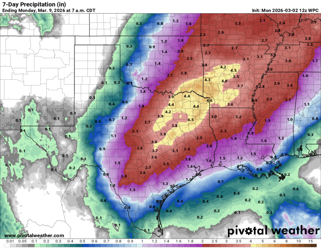
This weekend will continue to see warm weather in the 80s, with fairly muggy air. The question is rainfall. And it is a legitimate question. A front is going to push down closer to the region, and stall somewhere. Depending where this stalls it could bring heavy rainfall to parts of Houston, but if it stops far enough north of the city then Houston is unlikely to see all that much rain. This makes the forecast difficult. In general I think most of the area will see between 0.5 to 1.5 inches of rain through Monday, but there is a risk of higher totals than this, or lower totals, and I expect amounts to vary widely. So we just need some more time to iron out a more detailed forecast for you. I know a lot of us are excited about the potential for significant spring-time rainfall, but it’s not a slam dunk yet.

Next week

At some point next week, perhaps on Wednesday, we are likely (although at this distance, not certain) to see a stronger front move all the way through the city and push offshore. This could bring another healthy chance of rainfall before exiting offshore, and push our overnight temperatures down in the vicinity of 50 degrees. We’ll see.

Saddle up Houston as we ride into a warm week with a good soaking at the end

In brief: In today’s post we discuss our unseasonably warm weather this week, which will persist into the weekend. The big thing we’re watching for is rain chances this weekend, which will be pretty high, although exact accumulations are impossible to forecast right now.

It is fairly warm across the greater Houston region this morning, and this probably will be our coolest morning of the week. (Weather Bell)

Rodeo forecasts

The Houston Livestock Show and Rodeo is back, and it will be with us for the next three weeks. We will be providing daily forecasts for attendees because so many people go. The average daily attendance is about 70,000, and last year the event set a record for attendance with 2.7 million people. Also, our long-time sidekick Reliant—our pard in cowboy parlance—is one of the main sponsors of the event. Conditions look fine for the first few days this week, but by the weekend we should see widespread showers. This isn’t so great for the fairway, but it will be very helpful for our soils and foliage as we move deeper into spring.

Monday

Conditions are fairly warm for early March out there, with temperatures in the low- to mid-60s this morning, and we are going to see warm-ish weather all week as a southerly flow dominates our weather. High temperatures today will reach the lower 80s, with mostly sunny skies and modest winds from the southeast.

Rodeo forecast

If you’re headed out to the Houston Livestock Show and Rodeo this evening we really have no weather concerns for you. Expect partly sunny skies before sunset with mild temperatures in the mid-70s before the show. Winds will be from the south at 10 to 15 mph. Afterward there will be increasing clouds with temperatures in the upper 60s. Overnight lows will not drop much further, only reaching the mid-60s for most of the region.

Tuesday, Wednesday, Thursday, and Friday

Our forecast won’t change much this week. A front will approach the area, but should stall out before moving into the Houston region. As a result each of these days should see high temperatures in the low- to mid-80s, with somewhat humid air. Overnight lows will fall only into the upper 60s. As a persistent southerly flow remains in place we can expect skies to be cloudy most of the time, and our nights to be warm. Daily rain chances will, overall, be on the order of 20 to 30 percent. Areas well to the northwest of Houston, such as College Station, have a better chance of seeing rain this week. Anyway, this will be our warmest and muggiest week of the year so far.

Saturday, Sunday, and Monday

The weekend looks rainy for much of the state of Texas as a series of disturbances push through. We still don’t have high confidence in rain accumulations for the Houston area, but there is the potential for 1 to 3 inches from Saturday through Monday, with higher isolated amounts. Rain totals area likely to be even greater for central and northern Texas, where locations could see 3 to 5 inches, and there is the potential for some flooding. (Matt will have more on the broader Texas implications on The Eyewall later this morning). Anyway, for Houston, I don’t expect wall to wall rain, but rather we should see cloudy skies this weekend with muggy temperatures and on-and-off showers. If you have outdoor plans we’ll be able to better refine the forecast the closer we get.

NOAA rain accumulation forecast for now through Sunday night. (Pivotal Weather)

Later next week

After unseasonably warm weather for the next week or so, by Tuesday or Wednesday of next week a cold front should push into the area. It’s a long ways off, but this should bring cooler nights back into Houston, with lows in the vicinity of 50 degrees or so. As always, at 10 days out, the details are pretty fuzzy.