Good morning from Dayton, Ohio, as this Rutgers alum heads back to Houston to recover from what was a gutting First Four loss to Notre Dame. Pain. I will be solidly behind both Texas Southern and UH for the men’s tournament this year, so good luck to them and to everyone filling out brackets. So I hope you’ll accept my apologies if today’s post has any typos (or was initially missing a title).
Thursday & Thursday night
Today should start off nice, outside of some low clouds and patchy fog in spots. We will warm well into the 70s this afternoon, with intervals of clouds and sunshine. You’ll also notice a steady south or southeast wind today, gusting to 20 mph or better at times. Rain chances aren’t too high through mid-afternoon. But there will likely be a few minor showers that develop after that time and into the evening. Not everyone will see rain (many actually will not), and the highest odds for anything heavier or steadier are likely east of I-45 this evening.

For those of you heading to see Chris Stapleton tonight at the Houston Livestock Show & Rodeo, expect at least a few showers around as you head into the show, with temperatures in the lower 70s. It may not be raining at NRG Stadium itself, but there will be at least a smattering of showers nearby. As you exit, there could still be some showers around, possibly even a rumble of thunder. Temperatures won’t have budged much in that time, still likely holding around 70 degrees.

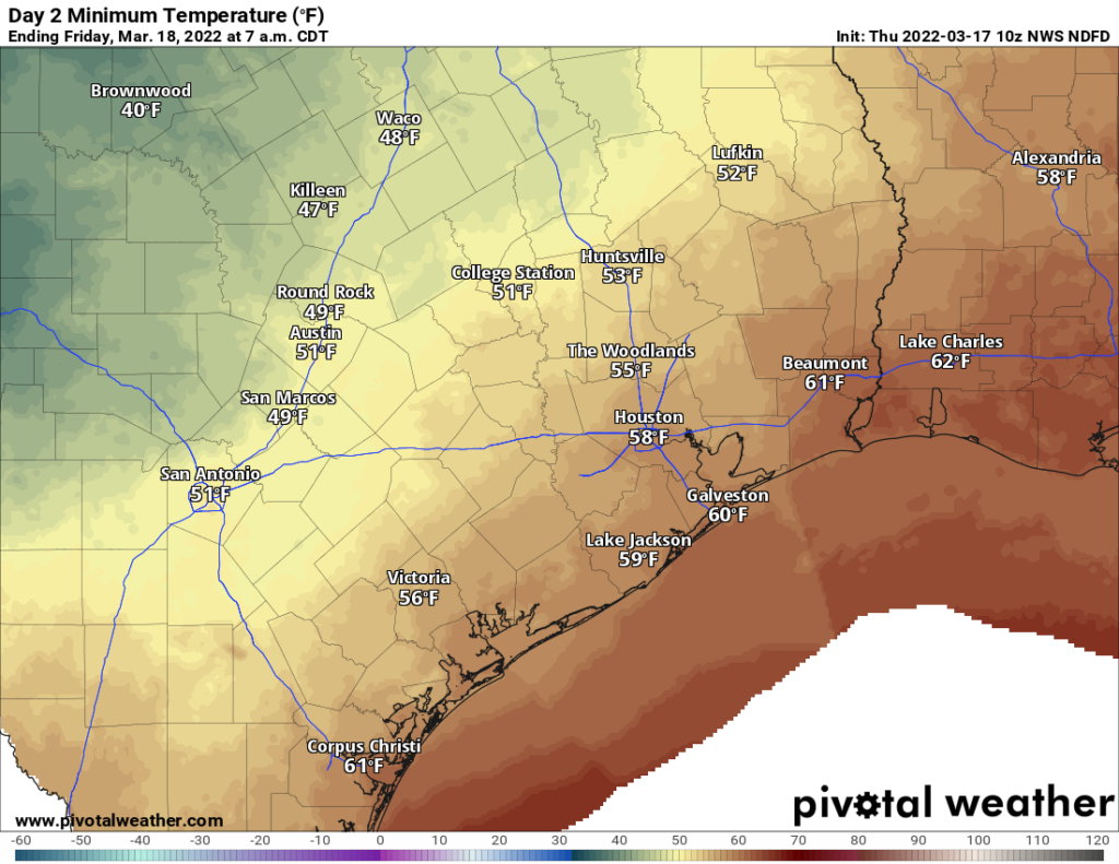
The cold front itself is expected to hit the Brazos Valley after 2 to 3 AM or so, the Houston area before sunrise, and the coast right around sunrise. It should arrive without too much fanfare in terms of storms. There will be a slight increase in winds and a change in direction, as well as a drop off of about 10 to 15 degrees, with lows in the 50s by Friday morning.
Friday
Since the front clears most of the region by daybreak, look for a blustery day Friday with increasing sunshine. This front isn’t especially strong, so we should still manage to find 70 degrees on Friday afternoon. Northwest winds will gust over 20 mph at times.
Weekend
We’re still on track for almost “chamber of commerce” weather this weekend: Sunshine, low humidity, 40s in the morning, 70s in the afternoons, with Sunday being slightly warmer than Saturday. Enjoy!
Monday
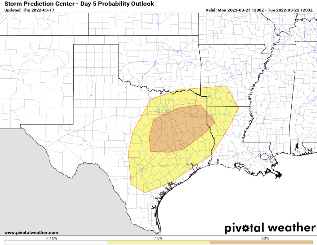
It continues to look as if Monday will be a day to watch for thunderstorms and potential severe weather. We continue to be highlighted on the Storm Prediction Center’s day 5 outlook, and they’ve actually increased the odds of severe storms north of Houston (basically for areas north of Hwy 105).

Models seem to be in good agreement today on elevated storm chances in our area Monday. This will come via much warmer, more humid air and a potent storm system passing to our north and dragging a cold front this way. You’ll notice a much warmer morning Monday (lows likely in the 60s instead of the 40s) and temps pushing into the 70s Monday afternoon. It will also be quite breezy on Monday, with southerly winds gusting over 20 to 25 mph at times.
The severe weather threat is murkier but it’s quite clearly in place on Monday. Exactly what that will look like, it’s a bit too early to say. In general, the farther north of I-10 you go, the greater the odds of severe storms, as outlined by the map above. But that does not necessarily mean Houston is off the hook here. Not everyone will see severe weather on Monday. There are still a fair amount of questions, and we’ll tackle this a little more tomorrow.
Later next week
The cold front itself should push through Houston by late Tuesday night or Wednesday. Before that, a trough well out ahead of the front will deliver a second round of storms Tuesday morning, some again possibly strong to severe. I think most of the area will at least see rain from that. We should then clear out Tuesday afternoon. I would not be shocked to see an actually decent day on Tuesday after the storms, depending on the exact timing. We should push back into the 70s and potentially make a run for 80 degrees.
The front itself will not come with much, as the atmosphere should be pretty well worked over by that time. It will set up a very nice middle and end of the week with sunshine expected Wednesday through Friday, along with cooler, mostly pleasant temperatures.
Isn’t it a bit weird to get so hopped up over what a bunch of college students do?
Its March Madness, stranger
First – – Matt, you are lucky to get out of Dayton alive. I grew up there, and the reason I am down here is there is nothing left of Dayton except for vacant homes, abandoned factories, and opioid addicts found dead in the streets or in said vacant homes. Miserable place to live. Oh, did I mention the gang wars? Please, for your own safety, don’t go back.
Second – – Keep it up with the great weather!!
Look up the definition of “hyperbole”
A bit harsh! It seems to be undergoing a bit of a revival. I have a friend up there who was my local host, and I found it to be quite nice!
Way to go Irish!
Wind…..wind, wind, wind, wind wind…….
I don’t ever remember this much consistent wind in all my years in H-town.
I have said the same thing. It always seems to be a good breeze these days, with stronger gusts in between. Almost every day. It’s hard because I ride a bicycle everywhere and a motorcycle sometimes. The constant roaring is tiring not to mention the effort to pedal into the wind.
Some studies have said climate change has caused an increase in wind overall. This is just one of many:
https://www.themainemonitor.org/wind-the-overlooked-wild-card-in-climate-change/#:~:text=A%202019%20study%20found%20that,more%20breezy%20and%20gusty%20conditions.
My original comment doesn’t seem to have posted, maybe because I included a link.
There are many studies that have shown an increase in wind caused by climate change. I suppose you could google them since I can’t post links
Links tend to get squashed. I manually added it. I’m kind of surprised by the impressions that it’s been so much windier this year than in years past. I don’t believe it’s too abnormal. I think the connection to climate change in our case may come via stronger storms coming off the Rockies perhaps. But I’m not sure. I’ll have to dig through the hourly data one day to see if there’s genuinely been a trend.
The linked paper really hedges, and doesn’t have any strong evidence for climate change and wind speed change being related. But just from my experience, it feels like there are strong winds quite often this year. I feel it because I ride a bicycle a lot, and motorcycle, too. And I’ve had things blow around in my yard. Last month I came home from the farmer’s market on a Saturday morning, and my dogs were out in front of the house. The wind had blown open the door, so they came out to wait for me.
Ugh, I know that (beloved college team loss) pain. I hope you will get to enjoy Rutgers in the tournament again and often in the future!
What are the odds of rain at Memorial Park about 6 p.m. this evening? I have had to reschedule so many tennis matches this season! Thank you.
We already have some showers and light rain popping up, so while I don’t think it’s going to be bad, if you can’t play in light rain or drizzle, then I’d prepare to possibly have to cancel.