In brief: A complicated winter storm for Houston next week continues to give us fits in weather modeling, with today’s flavor being the potential for more snow and sleet than anything else. However, we expect the forecast to continue changing over the weekend and will keep you posted. Either way, travel across the Houston area may become very difficult Tuesday and Wednesday.
Winter storm update
What has changed since yesterday? Well, a lot. The storm is back. But this time it’s a bit colder overall, which means perhaps more in the way of snow and sleet than ice. That would be good news. That said, there remains a ton of uncertainty. As a native of New Jersey and having cut my teeth forecasting in Upstate New York, I have learned to never take a winter weather forecast from models literally. This is doubly true in the South where snow and ice are generally outside the bounds of climatology, which tends to give models fits and leads to us having to caveat every single thing we say.
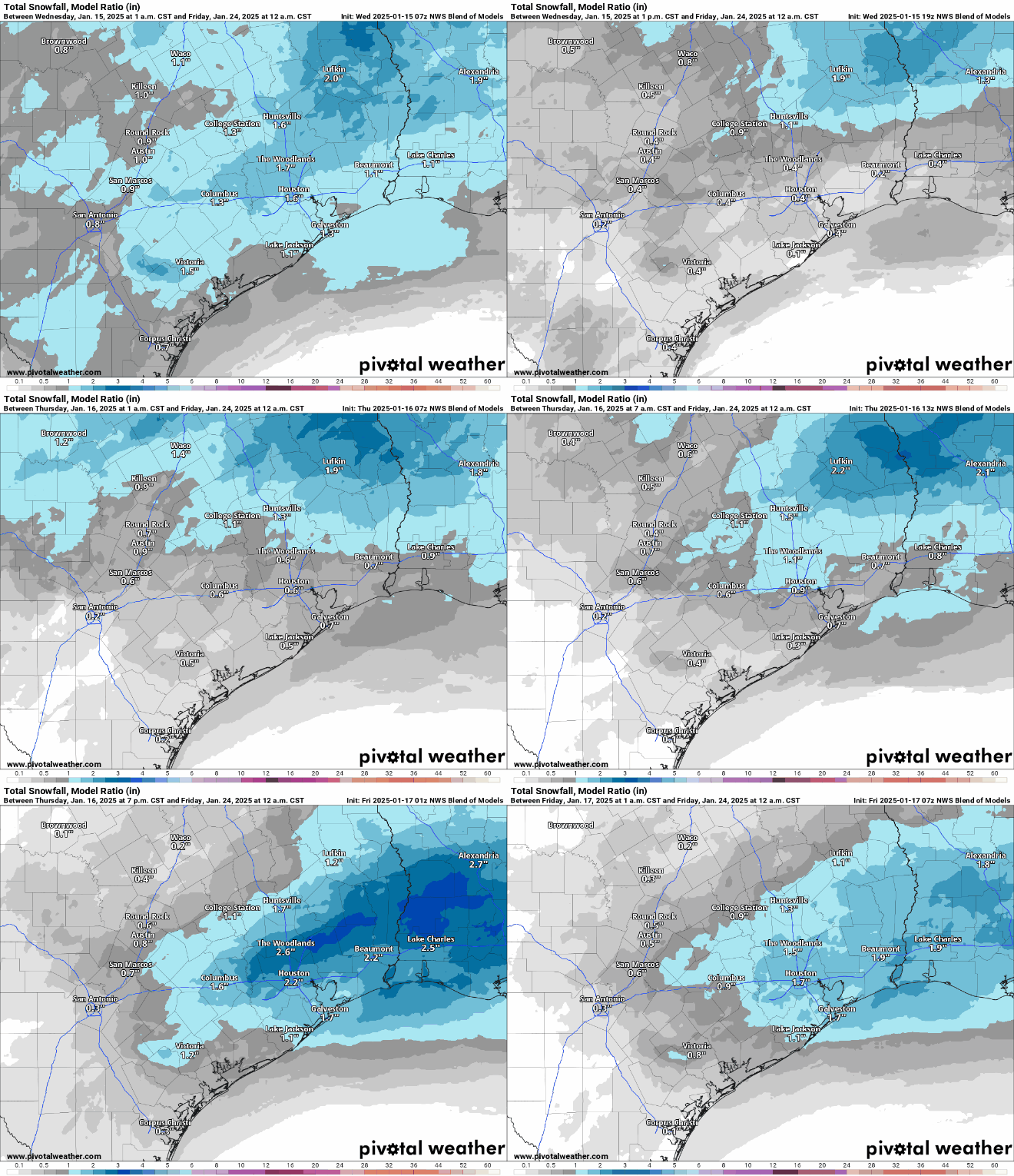
Anyway, here’s the NWS National Blend of Models snow forecast for the last several runs. This incorporates a bunch of models and weights them. You can see a lot of fluctuation in outcomes here.

What are we confident in? The timing. Precipitation should begin, lightly on Monday afternoon or evening. The height of the storm would likely be from about 4 AM to Noon Tuesday, with conditions slowly improving Tuesday afternoon. We are also fairly confident that Wednesday morning should be the coldest morning next week. A tropical-plant damaging freeze is likely on at least one or two mornings. An irrigation system damaging freeze is also likely if precautions are not taken.
What are we not confident in? How much of what falls where. While the models have brought the storm back into the forecast since yesterday, they remain a bit split on exactly how it plays out. We can say that in general today, it appears the highest odds of snow are north and east of Houston and the highest odds of ice are south of Houston and near the coast. Beyond that? We can’t say much. Unfortunately, that’s the most important question to answer in terms of travel conditions, school closures, etc. We will get some confidence on this through the weekend. We would think that by the morning of the MLK holiday, decisionmakers will have enough to work with.
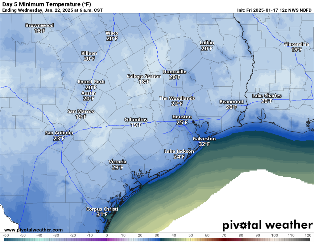
What else aren’t we confident in? How cold it gets Wednesday morning. Snow cover is a significant component of what we refer to in meteorology as “ideal radiational cooling,” the premise being clear skies, light winds, and snow cover all contribute toward an ideal scenario for cold weather. Without snow cover next week, we’ll likely see mostly 20s for lows with a few teens north. Cold for sure, but nothing extreme. However, let’s say we get 2″ of snow across Houston. Then we could easily shave an additional 5 degrees off that, nudging us into the teens everywhere except the coast.

So there is a lot to unpack here still, and over the next couple days we should begin to see clarity. Eric and I will keep you posted on all that as it evolves with regular updates through the weekend.
Houston Marathon
I admire anyone that runs a marathon. I especially admire anyone that does so with temperatures in the 30s and a north wind gusting up to 25 mph or so. That’s what we have for you on Sunday. Temps will rise a little through the run, possibly getting to near 40 degrees by the end, but either way, it’s going to be very cold. Good luck to Eric and to all those participating in the run(s) this year!
Rest of the forecast
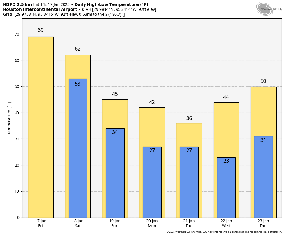
For those of you with weekend plans, there could be an isolated shower this afternoon or tomorrow afternoon as the front moves in, but otherwise it looks dry. Temperatures will peak in the upper-60s or low-70s today, so bust out the shorts and enjoy! Tomorrow will likely get into the 60s before the front hits in the afternoon. Temperatures will then fall tomorrow evening through the 50s and 40s and into the 30s in most of the area, with some 20s in more rural spots north of I-10 by Sunday morning. Sunday gets up to the low or mid-40s, maybe and looks windy and cold.
Monday will start in the 20s and warm into the upper-30s to low-40s. Depending on how the storm evolves, look for lows in the upper-20s and highs in the low or mid-30s on Tuesday with a breeze as well. Wednesday will probably get up near 40, but as noted above, there is some uncertainty on how cold it gets in the morning. And then a more proper warm up ensues for later next week.
Again, we will keep you posted regularly through the weekend on next week’s cold and potential winter precipitation.


Thanks for not showing the insanity that the Euro is showing. I will eat my hat if we get 8″ up in the Woodlands.
GFS*
What this means, is that people will be driving like idiots on the overpasses and freeways.
Facts 💯
Last I checked, GFS was pretty tame. It was the ECMWF that is showing something like 2 feet of snow as of this morning. 😀
Ty for the information ⛄
Is its “Just” snow whether it be 1, 2, or even 3 inches but no ice/freezing rain, would that mean school/business should be open as usual on tuesday?
If there is snow, schools will close
The issue is, the whole city doesn’t know how to prepare for snow. Txdot? Maybe, but the rest of Houstonians have no clue. Per usual, if it snows, we will see 20+ accidents!
They’ll close schools no matter what amount of snow, bank on it.
Not if it snows 2 inches. The whole city will shut down.
“in more rural spots north of I-20”
Just a simple typo but that’s the DFW region.
Thanks for catching that. I also typed “ideal rational cooling” instead of “radiational cooling,” so it’s a banner morning over here.
Losing mind: intensifies
You need to understand, here: I am literally 4 inches of collar away from a new sweater and I’m actually going to be able to wear it after knitting on it for 900 years! (also: snow)
Shoutout to all the local companies preemptively telling employees they’re coming in on Tuesday no matter how bad road conditions are!
I don’t get why Yankees have the mistaken idea that the South doesn’t get snow and ice. Granted, here on the Gulf Coast it’s less frequent but snow is common in much of Texas as well as the rest of the South. (Yes, Texas is in the South.) I’ve lived around Houston off and on since 1994 (I was transferred back to Kentucky – which has tons of snow – then to Ohio) and I’ve seen snow and ice numerous times, including on Christmas Eve 2004. In fact, the South probably gets more ice than the North does because of overriding warmer air above cold air sliding in below. It’s all relevant to the location of the Jet Stream and the amount of moisture coming out of the Gulf. That Christmas Eve snowstorm brought almost a foot along the coast. Maybe the models aren’t properly written to account for colder Southern temperatures. Maybe forecasters ought to get away from their computers and look at the maps.
Models aren’t concerned with geographic boundaries that we print on maps. They are concerned with points of data.
In 2004 I had a colleague go home to Pennsylvania for the holiday because he wanted to see some snow. It was in the 50’s up there on Christmas Eve.
2021 scared me. I’m super concerned about this, and I have no trust in our grid or the bleeps who run this state. Trying to breathe right now is challenging. 🙁
Exact same here.
This will be nothing like the 2021 freeze, not nearly as cold and nearly as long an event as that one. Take a deep breath, cover your above ground pipes and cover plants as needed and be careful driving on Tuesday if you have to, that’s it. This is a NORMAL Houston winter weather event, Feb 2021 was not.
From the opening paragraph of Matt’s post, this statement should be required reading by everyone before complaining during & after winter weather events along the Gulf Coast when a forecast misses or does not account for every nuance of the weather – “As a native of New Jersey and having cut my teeth forecasting in Upstate New York, I have learned to never take a winter weather forecast from models literally. This is doubly true in the South where snow and ice are generally outside the bounds of climatology, which tends to give models fits and leads to us having to caveat every single thing we say.”
Are you the same person that went off about capitalism and education system in yesterdays post?
Yeah. I’ll take Bill Paxton over AI any day.
The entirety of our weather forecast is based on advanced technology, let alone everything else in society. Matt and Eric do a fantastic job of breaking down the data with very little fluff and will call themselves out when they are wrong or missed something.
“Everything … in society” is “based on advanced technology.” Exactly, that’s the problem.
To be fair, the real problems with technology have absolutely nothing to do with mistakes in weather forecasting. If we could forecast the weather perfectly, people would end up imagining that we are in control of nature and try to play God (even more than we currently do), and thus be even worse off, morally speaking, than we are now.
By the way, Perseverance, the Canadian model always shows absurdly cold temps, that’s just the way it always works for some reason. It’s not a forecast.
I am driving back from Austin on Sunday afternoon. Any precipitation to worry about on the roads?
Drive through the town of La Grange. Don’t take the overpass that curves into I-10. That particular bridge/overpass that directly bypasses La Grange ices over very easily, and it’s inclined down and in towards the curve.
So vehicles can slide around, come to a stop, then they start sliding backwards and down off the overpass to tumble into a pile at the lowest point.
Seen this happen with my own eyes.
Just drive through La Grange proper.
The NWS discussion this morning is funny. The short-term outlook starts, “Hello, welcome to the short term discussion – are you lost, I’m sure you’re probably looking for the long term section. Well, why not take a moment and read this section while you’re here? It’s not as exciting as the weather to come, but we’ve still got some stuff going on here, too.”
That was Luchs who wrote the short term – he’s always funny! I’ve emailed with his coworker and she said, yeah, he’s got a great sense of humor.
Whelp, my weekend plans are trying to get temporary greenhouses built around my tropical plants!
Same!
My plan is Christmas lights under freeze cloth.
This is exciting!
This is Texas so unfortunately this report is missing the most critical piece of information — impact to the power grid . Can you please advise?
1) potential of rolling blackouts
2) potential of power line freezing with frozen precip that will cause those of us who do not live near a hospital, fire station or school to lose power for multiple days until CP can repair.
Matt and Eric can’t do everyones reporting. ERCOT said they are preparing, so hopefully thats the case
Hello @D.R. … this link might be of assistance:
www [dot] ercot [dot] com [slash] gridmktinfo [slash] dashboards
(I would paste the actual URL, but then the my post has to be reviewed by a Moderator, and that could take minutes to hours to happen).
Our Grid for the most part is fine. February 2021 was a freak storm that the state wasn’t prepared for.
if the grid scares you that much move to California where there are brown outs all the time during wildfire season to “protect” against wildfire spread. so tired of people pretending like Texas and Oklahoma having an independent is some act against nature. cheaper energy is worth having some issues now and again, we also aren’t beholden to the eastern or western grids and all the stupid regulations that drive the energy prices up that come with it.
Cmon baby, hold together…
Matt, how does Houston Marathon forecast compare to historical cold races we’ve had? Seems like this one will rank towards bottom!
I am skeptical of the models accuracy when it comes to frozen precipitation in our neck of the woods. The Christmas Eve blizzard of 2004 was not even picked up on by the models. The snow on the south side of town during the winter of 2017-2018 was a surprise. Then during the Valentine’s Day massacre freeze in 2021 the models were forecasting some apocalyptic totals for our area that never materialized.
I’ve been around too long and seen to many busts to put faith in the models when it comes to the white stuff…
Except for one winter in upstate NY I’ve lived in Texas for 80 years. I drove from Oshawa, ON to Beacon, NY through a significant lake effect storm January 1966. I am amazed you find SE Texas weather tougher than upstate NY. BTW, you are the best I have ever seen; I got my pilot license in 1964 — I’ve seen plenty.
Just received an email from ERCOT a few minutes ago:
—- quote:
.
ERCOT has issued a Weather Watch for January 20-23 due to extreme cold weather across the ERCOT region, higher electrical demand, and the potential for lower reserves.
.
Winter precipitation is also expected across parts of the state. Grid conditions are expected to be normal. For more information, visit our TXANS webpage.
.
What is an ERCOT Weather Watch?
An ERCOT Weather Watch is an advance notification of forecasted significant weather with higher electrical demand and the potential for lower reserves. At this time, grid conditions are expected to be normal, and there is not a current expectation of an energy emergency. Texans should continue to monitor real-time and extended grid conditions at ercot.com.
.
What do I need to do?
No action is needed. You can monitor current and extended grid conditions on ercot.com.
—- end quote
Treat the possible ice storm/ snow like an approaching hurricane. Stock up on three days of non-perishable food, batteries, bottled water, etc. If you are going anywhere and the news is reporting iced over freeway overpasses, etc., take the side streets as much as possible. Give oneself plenty of time.
Be careful on the freeways especially the overpasses and bridges. From my experience, I approached the bridges and overpasses, foot off the gas pedal and enter on a glide. People from up north may have different advice.
I have driven through the aftermath of an ice storm. It was a meandering path through side streets to work. It took about an hour or more. There was less traffic.
Stock up, drive safely. This is my experiences only,
We randomly decided to take kids to Disney and flying back Monday night. Am I being too brave? Everything says it’s not starting until Tuesday. I know you’ll keep us updated and I appreciate you guys so much!
Just finished taking my blood pressure using my VA-provided home BP machine, and this showed up:
^Msg From Your Care Coordinator*
Dear Veteran. Potential for freezing temperature forecasted to be in our area early next week.
Please make preparations now and also cover your plants, pipes, and protect your pets.