In brief: Houston will see another warm and humid day, but there will be a twist this afternoon as a broken line of showers and thunderstorms pushes through the area from northwest to southeast. Drier air will follow overnight, leading to sunny days with lower humidity. It’s a weak front, but in September, who’s complaining?
Wednesday
Most of the area will be warm and humid again today, with high temperatures in the low-90s. Skies will be mostly sunny this morning, but then we should see some clouds building up this afternoon with increasing levels of moisture in the atmosphere. By later this afternoon we should see a broken line of showers, perhaps with a few embedded thunderstorms, moving from northwest to southeast across the area. This line should reach from Sugar Land to downtown Houston to Kingwood by around 4 to 6 pm, and push down to the coast by around 7 to 9 pm.
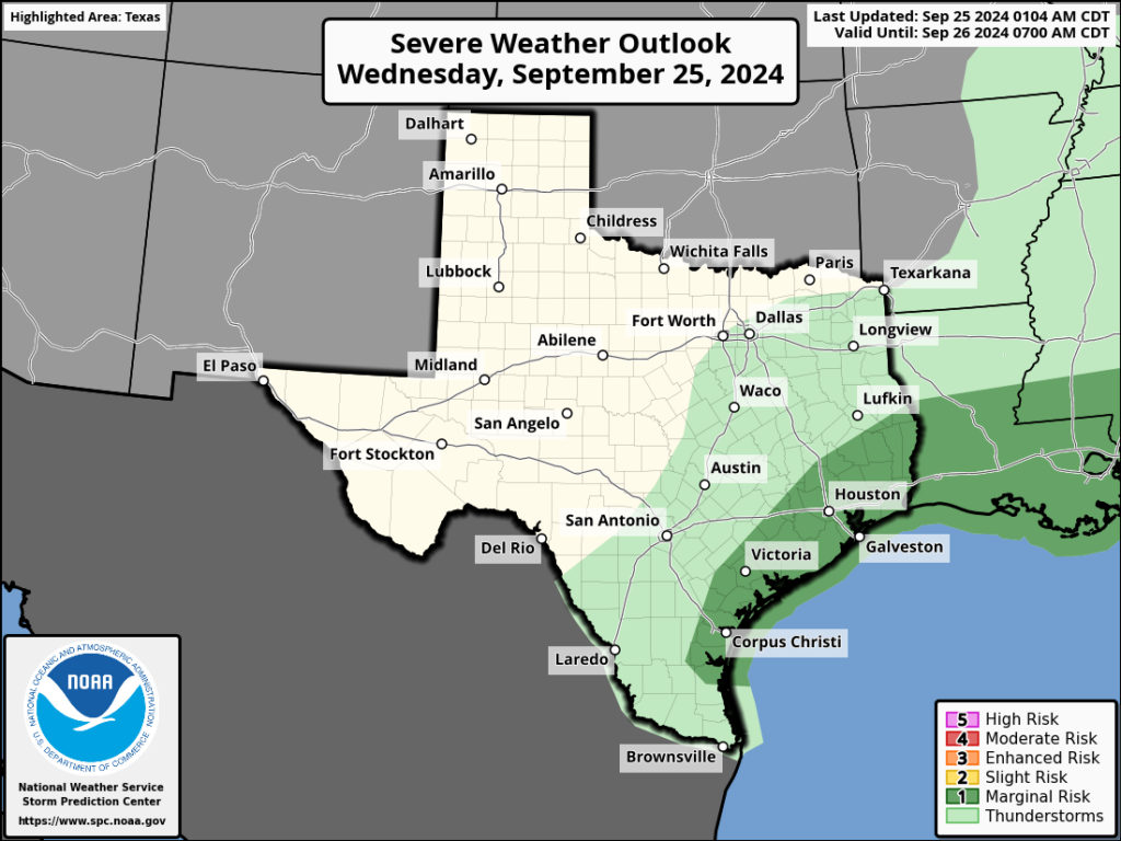
As it nears the coast, this boundary should gradually run into more moisture, and this could help fill in the gaps. There is a slight threat of some briefly damaging winds in any of the stronger thunderstorms that develop. Unfortunately, I don’t think the frontal passage is going to bring widespread, drenching rains, which the area needs after a fairly dry September. Some locations may pick up 0.5 inch of rain, but most of the region, and especially areas inland of Interstate 10, are likely to see little to no rain. Lows tonight will drop to around 70 degrees.
Thursday and Friday
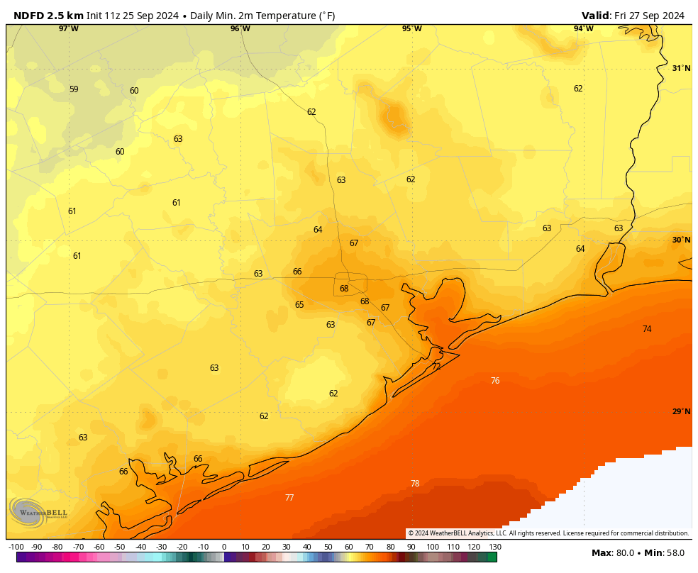
Drier air starts to filter in overnight, and we’ll see a couple of slightly cooler days. High temperatures on Thursday and Friday will reach the upper-80s, with lots of sunshine. Thursday may be a bit gusty in terms of northerly winds, but these will settle down somewhat by Thursday night. Lows, for the most part, will reach the upper 60s in the Houston area and drop down a little further outside of the city and away from the coast. Mornings and evenings will feel lovely.
Saturday and Sunday
Sunny weather continues, with daytime highs in the low 90s and nighttime lows around 70 degrees. The humidity will recover some, but not get back to really sticky dewpoints. So again, mornings and evenings will be fairly pleasant outside.
Next week
Expect more sunshine and highs in the low-90s. There is some support for a front arriving by Thursday or Friday of next week, but it is far from universal in the weather model ensembles. What does seem clear is that, after today, rain chances are very low for awhile for our area. That’s one reason why I’m hoping for today’s showers to overperform expectations.
Tropics
Now entering the Gulf of Mexico, Tropical Storm Helene is approaching hurricane strength with 70-mph sustained winds. It is expected to become a powerful Category 3 hurricane before striking the northwest Florida coast on Thursday evening. This storm will have widespread, myriad effects. We’ll have continuing coverage today on The Eyewall.

Hooray for cooler weather!
Yes!!
I ordered the new book “Reentry” from Blue Willow Bookstore https://bluewillowbookshop.com/pre-order-reentry last night. Their website says “UPDATE: If you’d like a personalized copy, you must place your order by 5:00 PM Friday, September 27, 2024. Any orders received after that date and time will be signed only.” and “If you want your book personalized (FIRST NAME ONLY), please indicate that in the comment section when you check out.”
I hope that you don’t mind Eric I requested that you personalize mine to my ARS Technica username (which is the same that I use here).
Well, no rain equals my grass is not growing. I’ll take it, I hate having to cut it so often when it does rain (i have an acre of it).
no rain means that I need to water my lawn (I have about 800sf of it) or it dies, the HOA gets mad, and I have to re-sod it. I’d love to be able to live on a lot with a 1 acre lawn… then again I did “mow” mine in 20 mins with an electric weedwhacker last night.
Xeriscaping is, by state law, allowable without HOA interference. Many here would be prudent to consider not having lawns trying to model golf courses. Doesn’t mean you have to rid yourself of all grass but you could certainly reduce the square footage, thus saving water, feeding, mowing and the wasted time that goes into it.
Does having nothing but dead grass and dead trees qualify as “Xeriscaping”? Call it the “Post Atomic Horror” look if you are a STNG fan.
Asking for a friend…..
Lol, you’re funny, Blackhawks.
Xeriscaping can be gorgeous. There’s lots of it in Corpus. It’s efficient and involves much less maintenance. I love Xeriscaping.
Do like we did – get a ten+ acre property away from the subdivision hoopla and hoa nonsense. No need to adhere to curbside appeal :). Takes about 3.5 hours to mow our pastures using the 12mph zero turn.
Looking forward to the incoming front here in Magnolia – no doubt will double our morning walk. It’s a shame for the folks in FL, GA, and AL who have to deal with another storm. Some are still recovering.
Would LOVE to get over ten acres, that’s my dream. get far enough away from the hustle and bustle and have a little wood shop and forge.
Ten acres is pricey these days. Unless you like the idea of living far out in the plaines of Oklahoma.
Very true, hence why it’s just a dream.
quote: “living far out in the plaines of Oklahoma.”
Not sure where that is – we are in Magnolia 🙂
And waiting for the front soon!
Or you can put up a perimeter fence now that they have changed the law. Then your yard is nobody’s business but yours.
The trouble is were entering a fall drought.
On my wx station, it picked up only .8” of rain in the past 30 days. After a decent rain summer, it’s not a good position to be in especially if we go into winter with a developing drought. Or just might be the typical early fall doldrums until the rains resume again.
Average rainfall for these upcoming months is 3.5″. I only got 0.15″ last night after weeks of dry, so I do hope we get up towards that average number. I really miss relaxing at home with thunderstorms rolling through.
“This line should reach from Sugar Land to downtown Houston to Kingwood by around 4 to 6 pm, and push down to the coast by around 7 to 9 pm.”
So, no use to the rest of us – and maybe for the majority of readers? Frankly, if the sweeties are not offered to all of us, they should not be offered to any. That’s how I treat my little dogs, it seems only right.
We are entering a La Nina fall and winter so I expect rain to be pretty sparse over the next several months. I hope I’m wrong but often times we go through long warm and dry spells with La Nina Fall/Winters. We will probably be back in a drought in a couple of months unless we have a sharp upper level pattern shift in mid October.
Yeah – expecting some brutally cold short spells.
In September of 1986,1998, and 2019 we never dropped out of the 70s. Considering that fact, I will welcome these few mornings in the mid to low 60s with open arms.
It’s been pretty bad for September in the early morning for plant safety rounds especially with the combination of humidity and all the PPE we need to wear. This will be a relief! (As will not having to do rounds next week!)
Had 2″ of rain on Monday but the lawn could certainly use more today.
I ordered Eric’s book from Blue Willow Bookshop last night.
To get a signed copy you should add /pre-order-reentry to the bookstores url.
If you’d like a personalized copy, you must place your order by 5:00 PM Friday, September 27, 2024. Any orders received after that date and time will be signed only.
Oh, wow! A fan! Next step is a poster of him on your bedroom wall. 😉
Uh, oh, you already have it? You are not going to become a stalker, are you?
Not likely. I’ve known Dwight (through HAAUG) & Lee (when he worked at the Babbages in Baybrook Crossing) for years. I met the rest of the Space City Weather Team at the Houston Botanic Garden meetup (last year?).
Sorry guys, I love you and respect your work. But it is awfully hot. It seems every year more livable weather is dangled before us and it always slips off into the distance. As soon as I retire I’m going north. I just can’t with this city anymore.