In brief: Cool air is settling back into the Houston area this morning, and a secondary push of it arrives Friday night. Look for increasing sunshine today, then plenty of sunshine through Sunday. Clouds and some scattered rain chances do come back next week, including potentially for Christmas Eve and Day. Temperatures will also surge back into the 70s.
Today & Friday
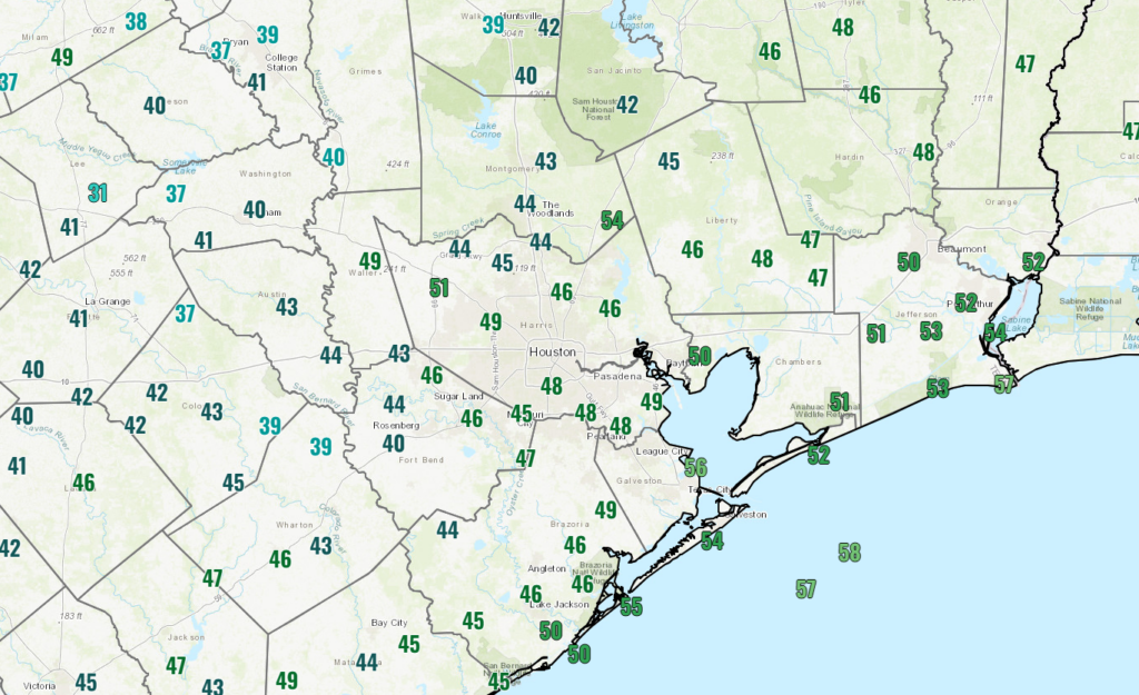
We’re starting off the morning on a cool, crisp note across the Houston area.

There are a couple pockets of low clouds that need to scour out this morning, but the trend today will be toward increasing sunshine with highs into the 60s in most spots.
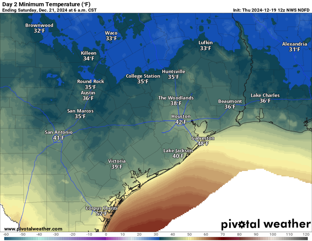
Tomorrow looks pretty similar overall. Sunshine should dominate the picture, with highs generally in the 60s and lows generally in the 30s to low-40s. A light freeze cannot be entirely ruled out way north of the city, probably up toward Crockett or Madisonville by Saturday morning. But no freezing temps are expected in the city or suburbs as it stands right now.

Saturday and Sunday
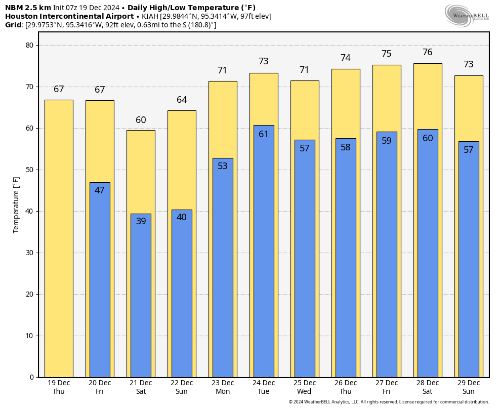
A weak secondary push of cold air arrives Friday night to extend the cool weather into the weekend. Our coolest day will probably be Saturday, also conveniently the Winter Solstice (at 3:21 AM for those of you looking to close out a fun Friday night on a celebratory note). Look for highs in the 50s, maybe low-60s south of Houston. Sunday should be a few ticks warmer with highs in the 60s and lows in the 40s. Both days look sun-filled.
Monday
Onshore flows kicks back in next week, and we’ll probably see a few more clouds on Monday in addition to some sun. We’ll ramp high temperatures back up close to 70 in the afternoon with lows in the 40s and 50s.
Christmas Eve
Timing-wise, the next storm system to impact the state is a bit suboptimal, moving in on Christmas Eve. The good news is that we do not expect a ton of rain and storms, but unfortunately there will be at least some rain and storms around on Christmas Eve that could play a role with any events on Tuesday. We move temps up to the low to mid-70s.

Christmas Day and beyond
Well, Christmas Day looks fairly similar to Christmas Eve right now with warm temps and some scattered rain chances. Morning lows should be in the 50s to near 60 on Christmas, with daytime highs ramping up into the mid-70s. We could get a weak cool front on Thursday with a chance of more numerous showers and storms and a slight cooldown for Friday. Then we should warm back up with at least a non-zero chance for an 80 again somewhere in our area next weekend or so. Our next meaningful front is at least showing on the models around New Years Day, but obviously that’s still 12 days out so don’t bank on that just yet.

Not fun fact: 2024 has officially tied 2012 for most 80 degree days at Hobby Airport at 243, and there’s a possibility of hitting the mark again the next week.
For the “we used to have colder winters when I was a kid” crowd.
Average temp in Houston 1900-1909 was 70.43.
Average temp from 1950-1959 was 70.36
Average temp from 2014-2023 was 71.07
So we are warmer by roughly 7 tenths of a degree but not by a large margin
That’s the average annual temperature. What’s the average temperature for January?
The average winter temperature in Houston from 1960-1991 was 53.5
Average winter temperature from 1971-2000 was 53.6
Average winter temperature from 1981-2010 was 54.2
Average winter temperature from 1991-2020 was 55.3
Average winter temperature from 1994-2024 is 55.5
Notice the trend? So yes, winter was cooler back then when we were kids. It is a demonstrable fact. Two degrees makes a big difference when considering averages.
Not that I’m questioning you, but a “big difference” can be better quantified by defining the standard deviation. That is, how many deviations defines where a 2 deg F difference falls? Without seeing a distribution of the temperatures, it’s hard to tell if a mean value is truly descriptive or if there’s skewness. At least a measure of variation can help with descriptive statistics.
There are always sharp variations with temperatures especially during the winter. That is why averages are set in 30 year segments. It is the best way to even out the high standard deviations that can occur year to year. The data is showing us that the 30 year averages are steadily going up for each month. Not just winter months. And the averages are warming at a faster rate each decade.
We can still get cold spells during winter but the warm days in between the cool spells are getting warmer and lasting longer especially over the past 10 years. The cool periods are getting shorter as well. When the 2001-2030 monthly mean averages come out, I am highly confident that they will be significantly higher than the 1991-2020 monthly mean averages.
The average meteorological winter (December-February) temperature from 1950-1959 was 57.0 which is warmer than the average temperature from 1994-2024 by 1.5 degrees. So by your logic would it be safe to say that if you were a kid in the 1950’s the winter temperature is actually cooling by a big difference when considering averages?
Yes, that is true. December, January, and February averaged warmer in the 1950s decade. The 1950s was a warm period, especially for Texas. That is why averages are spread through a 30-year period, not 10. However, every other month except October for the 1994-2024 average is still warmer than the 1950-1959 period. October is a tie. If you only use 10-year averages, then you are going to see constant sharp ups and downs. The broad trends become much clearer using the 30-year method. Since the 1970s, 30-year average temperatures have been steadily going up with no down trends and it doesn’t seem like that is going to stop anytime soon. These near-record and record-warm months we keep having are certainly not helping. We may enter another cool period someday; who knows? I can dream, can’t I?
I know the main argument was about winter, but I am also concerned about the rapid warmth I’ve noticed throughout the other seasons as well.
The climate has never been stable. The 50’s were warm and the 70’s were cold. There are decadal and multi-decadal oscillations. Bottom line is the region has seen about 3/4 of a degree in warming over the last 125 years are so. Some of that can be attributed to urban sprawl and the heat island effect. Some of the warming is likely due to man. I just don’t give into the media hype that every heat wave (and arctic outbreak) is due to man and our use of fossil fuels.
How about in the Bronze Age, when I was a kid?
People also tend to remember isolated weather events regardless of the season. The 2021 winter event was not the norm for the entire winter but everyone talks about Uri and the “winter of 21”. I remember when I was a kid, we had three snowfalls over the course of the same winter (early 1970’s), when snow wasn’t falling on those days I was at school in short sleeves. This is Houston, a warmish Christmas is more the norm.
Absolutely, People tend to remember extreme weather events. Storms, polar outbreaks, floods etc. I remember the extreme freezes in the winters of 1983 and 1989 as well as the Christmas Eve Blizzard of 2004 but that certainly is not the norm.
Hell yeah! The Christmas snowstorm of 2004 was the GOAT. That was my favorite Christmas ever. The accumulation was up to a foot where I live.
You must live near Bay City?
I guess the best we can do is celebrate Christmas this Saturday.
Celebrating Christmas is NOT about the temperature.
Bougainvillea is such a pain to clean up after a hard freeze. Covered with sharp claws….
This will likely end up being amongst the top 10 warmest Decembers on record. This is right after practically tying the record warmest October and November on record. Tell me the average climate isn’t warming.
The average climate isn’t warming.
Ha ha 😅
The average climate is warming a little…