In brief: We have a comprehensive update on what we expect to be two rounds of storms, one early Saturday, and another later on Saturday evening, that are likely to buffet Houston with heavy rains and strong winds. In between we still expect to have fair conditions for our Fall Day celebration on Saturday. And we have fall-like weather in the forecast to celebrate!
Fall Day update
As we noted yesterday, despite the prospect of storms this weekend, we plan to press ahead with our Fall Day celebration from 10 am to noon CT on Saturday, at Midtown Park. Yes, there will be storms early Saturday morning, but we expect the main line to have largely cleared by the time of our event. Temperatures should be in the low 70s. If there are a few scattered showers we will have plenty of cover at the park. We continue to watch the forecast closely, and will adjust our plans accordingly if conditions are unsafe. But right now the weather looks favorable for mid- to late morning on Saturday. And we have reasons to celebrate: drought-busting storms and the promise of much cooler weather next week. See you there?

Friday
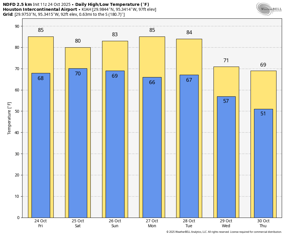
Skies today should start out mostly clear, but we’ll see clouds building this afternoon as atmospheric moisture levels rise. We should see some scattered showers south and west of Houston later this afternoon and evening, but coverage will be rather sporadic. Expect highs in the low- to mid-80s for most locations. It will be breezy, with southeasterly winds gusting up to 25 mph.
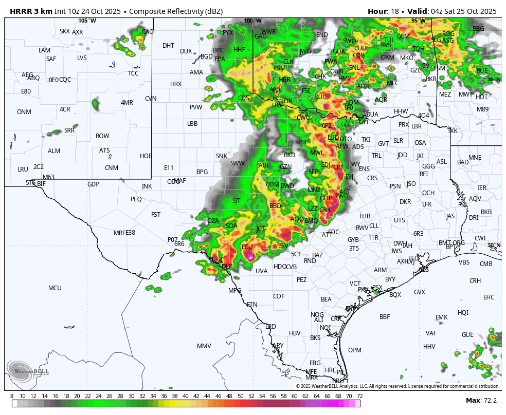
Tonight we will need to cast our gaze to the west, as a strong line of thunderstorms (in association with an upper-level disturbance) forms in Central Texas along the I-35 corridor and begins to march toward Houston. In terms of timing I expect this line to reach College Station around 1 to 3 am; the central Houston area between 3 and 6 am, and the coast between 6 and 8 am. This line of storms should bring 1 to 2 inches of rainfall, with higher isolated totals, in addition to the potential for damaging winds and perhaps an isolated tornado.
We’ll be back with a forecast update later today to confirm the timings above.
Saturday
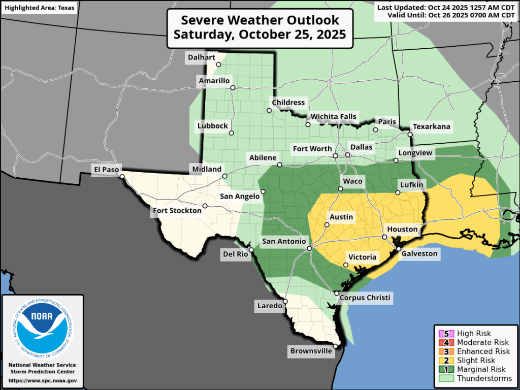
This line of storms should move eastward by mid-morning, leaving in its wake some scattered showers and possibly a few hours of clearing skies. However, by Saturday afternoon or evening we are likely to see the formation of another storm system to the northwest of Houston, in association with a weak front. This is likely to bring another round of storms into the metro area during the evening or overnight hours. These storms could be just as severe as those early Saturday morning, with the added bonus of hail. So it could be a second night for excitable dogs. Anyway I’m hopeful (but not certain) this second system will have moved through by around midnight or shortly after. Things should calm down a bit in its wake.
In terms of total rainfall, both of these rounds of storms should bring a combined 2 to 4 inches to most locations, with higher isolated totals. I don’t anticipate widespread flooding given how parched our soils are, but the heaviest rains will be coming at night, so please take care on roads and do not drive into high water. Hazards may be hidden.
Sunday
Some showers may linger on Sunday morning, but I expect to see clearing skies and, with slightly drier air, a pleasant day with highs of around 80 degrees.
Next week
Monday and Tuesday should be slightly warmer days, with highs in the low- to mid-80s. However, a front with more cold air behind it looks set to arrive on Tuesday, and this will usher in decidedly fall-like weather for the remainder of next week. (Probably not much, if any, rain with this front). We are talking a few days of highs in the 70s (Thursday might even top out in the 60s) with nights probably in the 50s through the weekend. Halloween, for the most part, looks to be clear and cool for your trick-or-treating desires. Ideal weather on Halloween in Houston? It’s been awhile.
